Articles | Volume 18, issue 4
https://doi.org/10.5194/gmd-18-1221-2025
© Author(s) 2025. This work is distributed under
the Creative Commons Attribution 4.0 License.
https://doi.org/10.5194/gmd-18-1221-2025
© Author(s) 2025. This work is distributed under
the Creative Commons Attribution 4.0 License.
NSOAS24: a new global marine gravity model derived from multi-satellite sea surface slopes

Shengjun Zhang
School of Resources and Civil Engineering, Northeastern University, Shenyang, China
Runsheng Zhou
School of Resources and Civil Engineering, Northeastern University, Shenyang, China
Yongjun Jia
CORRESPONDING AUTHOR
National Satellite Ocean Application Service, Beijing, China
Related authors
Yong Wang, Shengjun Zhang, and Yongjun Jia
Ocean Sci., 21, 931–944, https://doi.org/10.5194/os-21-931-2025, https://doi.org/10.5194/os-21-931-2025, 2025
Short summary
Short summary
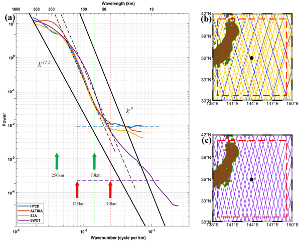
The distance-weighted averaging method was used to calculate the along-orbit sea surface height (SSH) wavenumber spectra of four satellites and to evaluate the along-track resolution capability of the four satellites. The results show that the resolution of Surface Water and Ocean Topography (SWOT) in the Kuroshio region is 25 km, which is twice the resolution of conventional satellites. A parameter was defined using the cross-power-spectrum approach and used to analyse the global ocean.
Huiying Zhang, Jinyun Guo, Shaoshuai Ya, Shaofeng Bian, Yongjun Jia, and Xin Liu
Earth Syst. Sci. Data Discuss., https://doi.org/10.5194/essd-2026-712, https://doi.org/10.5194/essd-2026-712, 2026
Preprint under review for ESSD
Short summary
Short summary
This study presents SDUST2025DOV_SWOT, a global 1′ × 1′ marine DOV dataset derived from SWOT/KaRIn two-dimensional sea surface height observations using local geoid fitting, and SDUST2025GRA_SWOT, the corresponding gravity anomaly dataset. Independent shipborne validation gives a global RMS difference of 3.82 mGal, with larger improvements in seamount and trench regions. The datasets provide new global marine gravity field data resources.
Mingtao Liu, Jinyun Guo, Yu Sun, Shaofeng Bian, Yongjun Jia, and Xin Liu
EGUsphere, https://doi.org/10.5194/egusphere-2025-4935, https://doi.org/10.5194/egusphere-2025-4935, 2025
Preprint archived
Short summary
Short summary
Sea ice is vital in the global climate system, ecological balance and polar navigation. Arctic sea ice concentration (SIC) exhibits significant spatial heterogeneity and complex evolutionary patterns. In response to address these challenges, this study proposes a predictive model named sea ice concentration U-Net (SICUNet). SICUNet is a data-driven U-Net model that integrates attention mechanisms and residual structures for short-term prediction of SIC in the Arctic region.
Yong Wang, Shengjun Zhang, and Yongjun Jia
Ocean Sci., 21, 931–944, https://doi.org/10.5194/os-21-931-2025, https://doi.org/10.5194/os-21-931-2025, 2025
Short summary
Short summary
The distance-weighted averaging method was used to calculate the along-orbit sea surface height (SSH) wavenumber spectra of four satellites and to evaluate the along-track resolution capability of the four satellites. The results show that the resolution of Surface Water and Ocean Topography (SWOT) in the Kuroshio region is 25 km, which is twice the resolution of conventional satellites. A parameter was defined using the cross-power-spectrum approach and used to analyse the global ocean.
Shuai Zhou, Jinyun Guo, Huiying Zhang, Yongjun Jia, Heping Sun, Xin Liu, and Dechao An
Earth Syst. Sci. Data, 17, 165–179, https://doi.org/10.5194/essd-17-165-2025, https://doi.org/10.5194/essd-17-165-2025, 2025
Short summary
Short summary
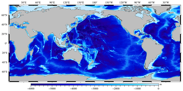
Our research focuses on using machine learning to enhance the accuracy and efficiency of bathymetric models. In this paper, a multi-layer perceptron (MLP) neural network is used to integrate multi-source marine geodetic data. And a new bathymetric model of the global ocean, spanning 0–360° E and 80° S–80° N, known as the Shandong University of Science and Technology 2023 Bathymetric Chart of the Oceans (SDUST2023BCO), has been constructed, with a grid size of 1′ × 1′.
Dechao An, Jinyun Guo, Xiaotao Chang, Zhenming Wang, Yongjun Jia, Xin Liu, Valery Bondur, and Heping Sun
Geosci. Model Dev., 17, 2039–2052, https://doi.org/10.5194/gmd-17-2039-2024, https://doi.org/10.5194/gmd-17-2039-2024, 2024
Short summary
Short summary
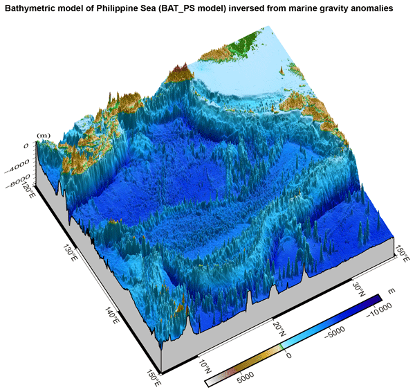
Seafloor topography, as fundamental geoinformation in marine surveying and mapping, plays a crucial role in numerous scientific studies. In this paper, we focus on constructing a high-precision seafloor topography and bathymetry model for the Philippine Sea (5° N–35° N, 120° E–150° E), based on shipborne bathymetric data and marine gravity anomalies, and evaluate the reliability of the model's accuracy.
Zhaoqing Dong, Lijian Shi, Mingsen Lin, Yongjun Jia, Tao Zeng, and Suhui Wu
The Cryosphere, 17, 1389–1410, https://doi.org/10.5194/tc-17-1389-2023, https://doi.org/10.5194/tc-17-1389-2023, 2023
Short summary
Short summary
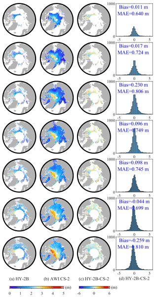
We try to explore the application of SGDR data in polar sea ice thickness. Through this study, we find that it seems difficult to obtain reasonable results by using conventional methods. So we use the 15 lowest points per 25 km to estimate SSHA to retrieve more reasonable Arctic radar freeboard and thickness. This study also provides reference for reprocessing L1 data. We will release products that are more reasonable and suitable for polar sea ice thickness retrieval to better evaluate HY-2B.
Cited articles
Andersen O. B. and Knudsen P.: The DTU17 global marine gravity field: First validation results, in: International Association of Geodesy Symposia, Springer, Berlin, Heidelberg, Germany, https://doi.org/10.1007/1345_2019_65, 2019.
Andersen, O. B., Rose, S. K., Abulaitijiang, A., Zhang, S., and Fleury, S.: The DTU21 global mean sea surface and first evaluation, Earth Syst. Sci. Data, 15, 4065–4075, https://doi.org/10.5194/essd-15-4065-2023, 2023.
Brammer, R. F. and Sailor, R. V.: Preliminary estimates of the resolution capability of the Seasat radar altimeter, Geophys. Res. Lett., 7, 193–196, https://doi.org/10.1029/GL007i003p00193, 1980.
Chen, X., Kong, X., Zhou, R., and Zhang, S.: Fusion of altimetry-derived model and ship-borne data in preparation of high-resolution marine gravity determination, Geophys. J. Int., 236, 1262–1274, https://doi.org/10.1093/gji/ggad471, 2024.
Fu, L.-L. and Cazenave, A.: Satellite altimetry and earth sciences: a handbook of techniques and applications, Academic, San Diego, USA, 493 pp., ISBN 978-0-12-269545-2, 2001.
Guo, J., Luo, H., Zhu, C., Ji, H., Li, G., and Liu, X.: Accuracy comparison of marine gravity derived from HY-2A/GM and CryoSat-2 altimetry data: a case study in the Gulf of Mexico, Geophys. J. Int., 230, 1267–1279, https://doi.org/10.1093/gji/ggac114, 2022.
Hao, R., Wan, X., and Annan, R. F.: Enhanced Short-Wavelength Marine Gravity Anomaly Using Depth Data, IEEE T. Geosci. Remote, 61, 1–9, https://doi.org/10.1109/TGRS.2023.3242967, 2023.
Li, Q., Bao, L., and Wang, Y.: Accuracy Evaluation of Altimeter-Derived Gravity Field Models in Offshore and Coastal Regions of China, Front. Earth Sci., 9, 722019, https://doi.org/10.3389/feart.2021.722019, 2021.
Mohamed, A., Ghany, R. A. E., Rabah, M., and Zaki, A.: Comparison of recently released satellite altimetric gravity models with shipborne gravity over the Red Sea, Egypt, J. Remote Sens. Space Sci., 25, 579–592, https://doi.org/10.1016/j.ejrs.2022.03.016, 2022.
Pavlis, N. K., Holmes, S. A., Kenyon, S. C., and Factor, J. K.: The development and evaluation of the Earth Gravitational Model 2008 (EGM2008), J. Geophys. Res., V117, B04406, https://doi.org/10.1029/2011JB008916, 2012.
Sandwell, D. T. and Smith, W. H.: Marine gravity anomaly from Geosat and ERS 1 satellite altimetry, J. Geophys. Res.-Solid, 102, 10039–10054, https://doi.org/10.1029/96JB03223, 1997.
Sandwell, D. T., Harper, H., Tozer, B., and Smith, W. H. F.: Gravity field recovery from geodetic altimeter missions, Adv. Space Res., 68, 1059–1072, https://doi.org/10.1016/j.asr.2019.09.011, 2021.
Stammer, D. and Cazenave, A.: Satellite altimetry over oceans and land surfaces, CRC Press, Boca Raton, https://doi.org/10.1201/9781315151779, 2017.
Wan, X., Annan, R. F., Jin, S., and Gong, X.: Vertical deflections and gravity disturbances derived from HY-2A Data, Remote Sens., 12, 2287, https://doi.org/10.3390/rs12142287, 2020.
Wan, X., Hao, R., Jia, Y., Wu, X., Wang, Y., and Feng, L.: Global marine gravity anomalies from multi-satellite altimeter data, Earth Planets Space, 74, 1–14, https://doi.org/10.1186/s40623-022-01720-4, 2022.
Wessel, P. and Bercovici, D.: Interpolation with Splines in Tension: A Green's Function Approach, Math. Geol., 30, 77–93, https://doi.org/10.1023/A:1021713421882, 1988.
Zhang, S. and Sandwell, D. T.: Retracking of SARAL/AltiKa radar altimetry waveforms for optimal gravity field recovery, Mar. Geod., 40, 40–56, https://doi.org/10.1080/01490419.2016.1265032, 2017.
Zhang, S., Andersen, O. B., Kong, X., and Li, H.: Inversion and validation of improved marine gravity field recovery in South China Sea by incorporating HY-2A altimeter waveform data, Remote Sens., 12, 802, https://doi.org/10.3390/rs12050802, 2020.
Zhang, S., Zhou, R., Jia, Y., Jin, T., and Kong, X.: Performance of HaiYang-2 Altimetric Data in Marine Gravity Research and a New Global Marine Gravity Model NSOAS22, Remote Sens., 14, 4322, https://doi.org/10.3390/rs14174322, 2022.
Zhang, S., Chen, X., Zhou, R., and Jia, Y.: A new global marine gravity model NSOAS24 derived from multi-satellite sea surface slopes, Zenodo [data set], https://doi.org/10.5281/zenodo.12730119, 2024.
Zhu, C., Guo, J., Gao, J., Liu, X., Hwang, C., Yu, S., Yuan, J., Ji, B., and Guan, B.: Marine gravity determined from multi-satellite GM/ERM altimeter data over the South China Sea: SCSGA V1.0, J. Geod., 94, 1–16, https://doi.org/10.1007/s00190-020-01378-4, 2020.
Zhu, C., Guo, J., Yuan, J., Li, Z., Liu, X., and Gao, J.: SDUST2021GRA: global marine gravity anomaly model recovered from Ka-band and Ku-band satellite altimeter data, Earth Syst. Sci. Data, 14, 4589–4606, https://doi.org/10.5194/essd-14-4589-2022, 2022.
Short summary
NSOAS24, a new global marine gravity model derived from multi-satellite altimetry missions, represents a significant advancement over its predecessor, NSOAS22. Through optimized processing procedures, NSOAS24 resolves previous issues and demonstrates improved accuracy. Compared to NSOAS22, NSOAS24 shows a reduction of approximately 0.7 mGal in standard deviation when validated against recent shipborne data. Notably, its accuracy now rivals internationally recognized models DTU21 and V32.1.
NSOAS24, a new global marine gravity model derived from multi-satellite altimetry missions,...