
Articles | Volume 19, issue 18
https://doi.org/10.5194/gmd-19-9103-2026
© Author(s) 2026. This work is distributed under
the Creative Commons Attribution 4.0 License.
the Creative Commons Attribution 4.0 License.
https://doi.org/10.5194/gmd-19-9103-2026
© Author(s) 2026. This work is distributed under
the Creative Commons Attribution 4.0 License.
the Creative Commons Attribution 4.0 License.
Model description paper
| 
25 Sep 2026
Model description paper |
| 25 Sep 2026
| 25 Sep 2026
Simulating SAR altimeter echoes from cryospheric surfaces with the Snow Microwave Radiative Transfer (SMRT) model version 1.7
Ghislain Picard
CORRESPONDING AUTHOR

Univ. Grenoble Alpes, CNRS, IGE, 38000 Grenoble, France
Justin Murfitt
H2O Geomatics Inc., Kitchener, Ontario, Canada
Elena Zakharova
E0LA ME, Toulouse, France
Pierre Zeiger
Univ. Grenoble Alpes, CNRS, IGE, 38000 Grenoble, France
Laurent Arnaud
Univ. Grenoble Alpes, CNRS, IGE, 38000 Grenoble, France
Jeremie Aublanc
Collecte Localisation Satellites (CLS), Ramonville-Saint-Agne, France
Jack C. Landy
UiT The Arctic University of Norway, Tromsø, Norway
Michele Scagliola
ESA-ESRIN, Frascati, Italy
Claude Duguay
H2O Geomatics Inc., Kitchener, Ontario, Canada
University of Waterloo, Waterloo, Ontario, Canada
Related authors
Adrien Ooms, Mathieu Casado, Sonja Wahl, Thomas Laepple, Alexandra Zuhr, Pete Akers, Ghislain Picard, Laurent Arnaud, Joel Savarino, Kira Rehfeld, Barbara Stenni, Giuliano Dreossi, Mauro Masiol, Amaelle Landais, and Valérie Masson-Delmotte
EGUsphere, https://doi.org/10.5194/egusphere-2026-4801, https://doi.org/10.5194/egusphere-2026-4801, 2026
This preprint is open for discussion and under review for Climate of the Past (CP).
Short summary
Short summary
This work presents new insights in the archival process of multi-annual climatic signal in the near surface firn at Concordia Station, East-Antarctica, from the new data set of high resolution stable water isotope profiles measured in a snow trench. The dated isotopic profiles covering 20 years are compared against overlapping precipitation and surface snow observations. This highlights the strong contribution of stratigraphic noise and post depositional effects to individual trench profiles.
Marta Stentella, Ghislain Picard, Petra Heil, Jacqueline Boutin, Emmanuel Dinnat, and Stuart Corney
The Cryosphere, 20, 4465–4489, https://doi.org/10.5194/tc-20-4465-2026, https://doi.org/10.5194/tc-20-4465-2026, 2026
Short summary
Short summary
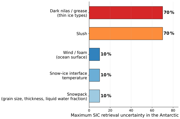
Passive microwave radiometers are the primary tool for monitoring Antarctic sea ice, but their reliability decreases in the marginal ice zone between the pack ice and the open ocean. We simulate satellite observations to assess the impact of varying physical parameters on sea ice concentration retrievals. The largest errors are due to flooded/wet snow, thin ice, and roughened ocean surfaces. These findings can improve our interpretation of satellite observations and forecast sea ice changes.
Philippe Gamet, Bimal K. Bhattacharya, Jean-Louis Roujean, Gilles Boulet, Corinne Salcedo, Albert Olioso, Kanishka Mallick, Marie Weiss, Emmanuelle Sarrazin, Emmanuelle Autret, Laure Roupioz, José Antonio Sobrino, Olivier Merlin, Ghislain Picard, Thomas H. G. Vidal, Mark Irvine, Rahul Nigam, Mehul Pandya, Simon Gascoin, Sébastien Marcq, Manoj K. Mishra, Emilie Delogu, Vincent Rivalland, Jordi Etchanchu, Jean-Louis Raynaud, Meenakshi Sarkar, Rishi K. Gangwar, Sushil K. Singh, Renaud Binet, Sara Arioli, Hervé Yésou, Isabelle Dadou, Alexei Kouraev, Julien Michel, Benoit Coudert, Samuel Mwangi, Nesrine Farhani, Ayan Das, Stéphane Saux-Picart, Thierry Tormos, Jean-François Piollé, Charles Verpoorter, Auline Rodler, Jonathan Leon Tavares, Jennifer Adams, Anand S. Sahadevan, Besavaraju Santhi Sree, Manikumar Vedantam, Dheeraj Adlakha, Laurence Buffet, Kathrin Naegeli, Itziar Barat, Jerome Demarty, Olivier Hagolle, and Philippe Maisongrande
EGUsphere, https://doi.org/10.5194/egusphere-2026-4492, https://doi.org/10.5194/egusphere-2026-4492, 2026
Short summary
Short summary
This paper highlights how the upcoming TRISHNA satellite mission (launching 2027) will transform Earth observation by providing high-resolution (60 m) thermal infrared imagery with sub-weekly revisits. It details the mission's design and its synergies with other future missions to significantly improve the monitoring of global surface temperature and its dynamics, water stress, and ecosystem energy processes.
Julien Meloche, Melody Sandells, Henning Löwe, Nick Rutter, Ghislain Picard, Richard Essery, Randall K. Scharien, Alexandre Langlois, Matthias Jaggi, Josh King, Peter Toose, Michele Scagliola, Jerome Bouffard, Alessandro Di Bella, and Christian Haas
EGUsphere, https://doi.org/10.5194/egusphere-2026-3615, https://doi.org/10.5194/egusphere-2026-3615, 2026
Short summary
Short summary
Sea ice thickness is essential for climate studies. Radar altimetry has provided sea ice thickness measurements, but uncertainty arises from the interaction of the signal with the snow cover. Therefore, modelling the signal interaction with the snow is necessary to improve retrieval. A radar model was used to simulate the radar signal from the snow-covered sea ice. This work paved the way to improved physical algorithms to retrieve snow depth and sea ice thickness for radar altimeter missions.
Adrien Ooms, Mathieu Casado, Ghislain Picard, Laurent Arnaud, Maria Hörhold, Andrea Spolaor, Rita Traversi, Joel Savarino, Patrick Ginot, Pete Akers, Birthe Twarloh, and Valérie Masson-Delmotte
The Cryosphere, 20, 3235–3255, https://doi.org/10.5194/tc-20-3235-2026, https://doi.org/10.5194/tc-20-3235-2026, 2026
Short summary
Short summary
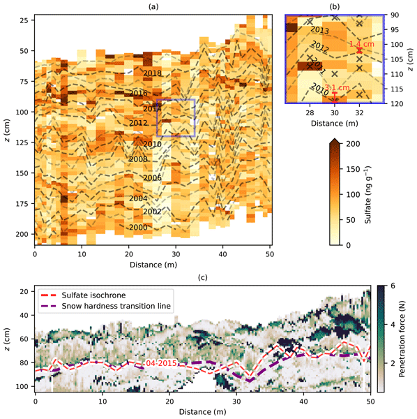
This work presents a new approach to the estimation of accumulation rates at Concordia Station, East-Antarctica, for the last 20 years, from a new data set of chemical tracers and snow micro-scale properties measured in a snow trench. Multi-annual and meter to decameter scale variability of accumulation rates are compared again in-situ measurements of surface laser scanner and stake farm, with very good agreement. This further constrains SMB estimation for Antarctica at high temporal resolution.
Titouan Tcheng, Elise Fourré, Christophe Leroy-Dos Santos, Frédéric Parrenin, Emmanuel Le Meur, Frédéric Prié, Olivier Jossoud, Roxanne Jacob, Bénédicte Minster, Olivier Magand, Cécile Agosta, Niels Dutrievoz, Vincent Favier, Léa Baubant, Coralie Lassalle-Bernard, Mathieu Casado, Martin Werner, Alexandre Cauquoin, Laurent Arnaud, Bruno Jourdain, Ghislain Picard, Marie Bouchet, and Amaëlle Landais
The Cryosphere, 20, 1599–1618, https://doi.org/10.5194/tc-20-1599-2026, https://doi.org/10.5194/tc-20-1599-2026, 2026
Short summary
Short summary
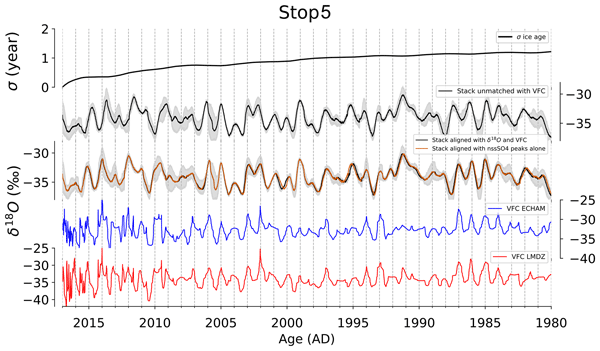
Studying Antarctic ice cores is crucial to assess past climate changes, as they hold historical climate data. This study examines multiple ice cores from three sites in coastal Adélie Land to see if combining cores improves data interpretability. It does at two sites, but at a third, wind-driven snow layer mixing limited benefits. We show that using multiple ice cores from one location can better uncover climate history, especially in areas with less wind disturbance.
Léa Elise Bonnefoy, Catherine Prigent, Ghislain Picard, Clément Soriot, Alice Le Gall, Lise Kilic, and Carlos Jimenez
The Cryosphere, 20, 1297–1314, https://doi.org/10.5194/tc-20-1297-2026, https://doi.org/10.5194/tc-20-1297-2026, 2026
Short summary
Short summary
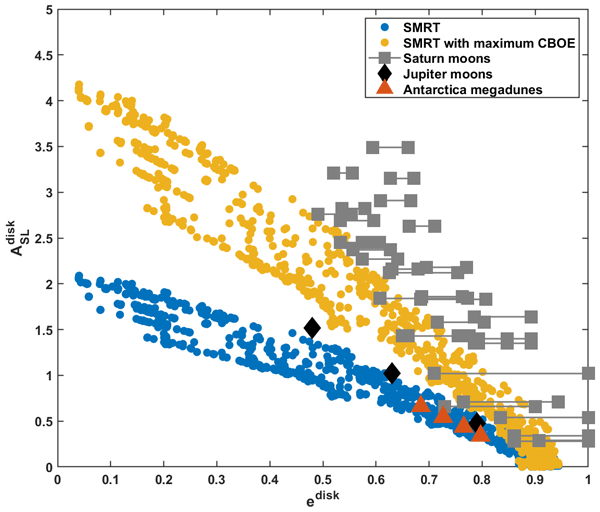
Microwave radiometry senses the thermal emission from a target, whereas its active counterpart, radar, sends a signal to the target and measures the reflected signal. We simultaneously model radar and radiometry over the East Antarctic ice sheet, which we propose as an analog for icy moons: we can reproduce most data with a unique model. The radar response of Saturn's moons cannot be reproduced and is likely caused by processes unaccounted for in the model and less efficient in the Antarctic.
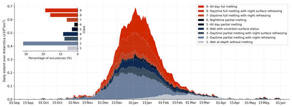
Marion Leduc-Leballeur, Ghislain Picard, Pierre Zeiger, and Giovanni Macelloni
The Cryosphere, 20, 1199–1216, https://doi.org/10.5194/tc-20-1199-2026, https://doi.org/10.5194/tc-20-1199-2026, 2026
Short summary
Short summary
This study presents a quantitative and synthetic classification of the snowpack in 10 dry-wet status by aggregating separate binary indicators derived from satellite observations. The classification follows the expected evolution of the melt season: night refreezing is frequent at the onset, sustained melting is observed during the summer peak, and remnant liquid water at depth occurs at the end. This dataset improves the knowledge of melt processes using passive microwave remote sensing.
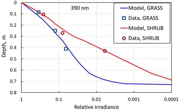
Florent Domine, Mireille Quémener, Ludovick Bégin, Benjamin Bouchard, Valérie Dionne, Sébastien Jerczynski, Raphaël Larouche, Félix Lévesque-Desrosiers, Simon-Olivier Philibert, Marc-André Vigneault, Ghislain Picard, and Daniel C. Côté
The Cryosphere, 19, 1757–1774, https://doi.org/10.5194/tc-19-1757-2025, https://doi.org/10.5194/tc-19-1757-2025, 2025
Short summary
Short summary
Shrubs buried in snow absorb solar radiation and reduce irradiance in the snowpack. This decreases photochemical reaction rates and emissions to the atmosphere. By monitoring irradiance in snowpacks with and without shrubs, we conclude that shrubs absorb solar radiation as much as 140 ppb of soot and reduce irradiance by a factor of 2. Shrub expansion in the Arctic may therefore affect tropospheric composition during the snow season with climatic effects.
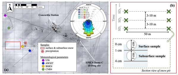
Inès Ollivier, Hans Christian Steen-Larsen, Barbara Stenni, Laurent Arnaud, Mathieu Casado, Alexandre Cauquoin, Giuliano Dreossi, Christophe Genthon, Bénédicte Minster, Ghislain Picard, Martin Werner, and Amaëlle Landais
The Cryosphere, 19, 173–200, https://doi.org/10.5194/tc-19-173-2025, https://doi.org/10.5194/tc-19-173-2025, 2025
Short summary
Short summary
The role of post-depositional processes taking place at the ice sheet's surface on the water stable isotope signal measured in polar ice cores is not fully understood. Using field observations and modelling results, we show that the original precipitation isotopic signal at Dome C, East Antarctica, is modified by post-depositional processes and provide the first quantitative estimation of their mean impact on the isotopic signal observed in the snow.
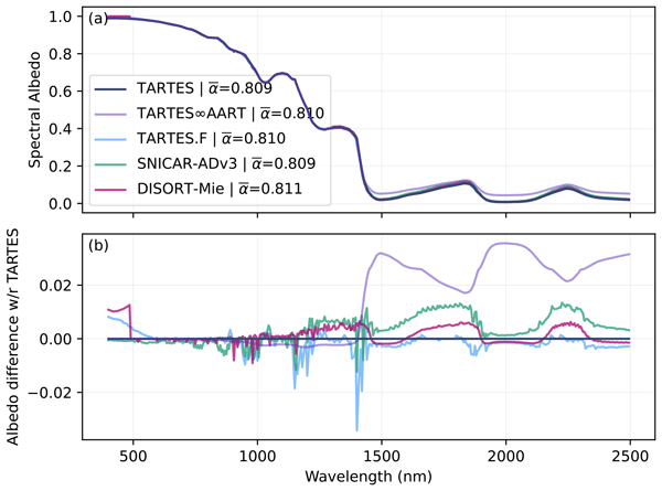
Ghislain Picard and Quentin Libois
Geosci. Model Dev., 17, 8927–8953, https://doi.org/10.5194/gmd-17-8927-2024, https://doi.org/10.5194/gmd-17-8927-2024, 2024
Short summary
Short summary
The Two-streAm Radiative TransfEr in Snow (TARTES) is a radiative transfer model to compute snow albedo in the solar domain and the profiles of light and energy absorption in a multi-layered snowpack whose physical properties are user defined. It uniquely considers snow grain shape flexibly, based on recent insights showing that snow does not behave as a collection of ice spheres but instead as a random medium. TARTES is user-friendly yet performs comparably to more complex models.
Melody Sandells, Nick Rutter, Kirsty Wivell, Richard Essery, Stuart Fox, Chawn Harlow, Ghislain Picard, Alexandre Roy, Alain Royer, and Peter Toose
The Cryosphere, 18, 3971–3990, https://doi.org/10.5194/tc-18-3971-2024, https://doi.org/10.5194/tc-18-3971-2024, 2024
Short summary
Short summary
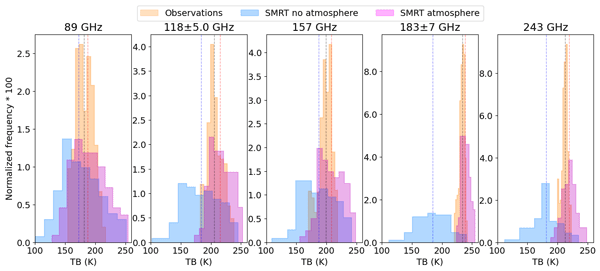
Satellite microwave observations are used for weather forecasting. In Arctic regions this is complicated by natural emission from snow. By simulating airborne observations from in situ measurements of snow, this study shows how snow properties affect the signal within the atmosphere. Fresh snowfall between flights changed airborne measurements. Good knowledge of snow layering and structure can be used to account for the effects of snow and could unlock these data to improve forecasts.
Sara Arioli, Ghislain Picard, Laurent Arnaud, Simon Gascoin, Esteban Alonso-González, Marine Poizat, and Mark Irvine
Earth Syst. Sci. Data, 16, 3913–3934, https://doi.org/10.5194/essd-16-3913-2024, https://doi.org/10.5194/essd-16-3913-2024, 2024
Short summary
Short summary
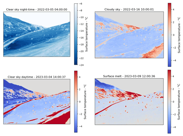
High-accuracy precision maps of the surface temperature of snow were acquired with an uncooled thermal-infrared camera during winter 2021–2022 and spring 2023. The accuracy – i.e., mean absolute error – improved from 1.28 K to 0.67 K between the seasons thanks to an improved camera setup and temperature stabilization. The dataset represents a major advance in the validation of satellite measurements and physical snow models over a complex topography.
Romilly Harris Stuart, Amaëlle Landais, Laurent Arnaud, Christo Buizert, Emilie Capron, Marie Dumont, Quentin Libois, Robert Mulvaney, Anaïs Orsi, Ghislain Picard, Frédéric Prié, Jeffrey Severinghaus, Barbara Stenni, and Patricia Martinerie
The Cryosphere, 18, 3741–3763, https://doi.org/10.5194/tc-18-3741-2024, https://doi.org/10.5194/tc-18-3741-2024, 2024
Short summary
Short summary
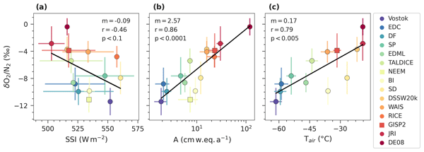
Ice core δO2/N2 records are useful dating tools due to their local insolation pacing. A precise understanding of the physical mechanism driving this relationship, however, remain ambiguous. By compiling data from 15 polar sites, we find a strong dependence of mean δO2/N2 on accumulation rate and temperature in addition to the well-documented insolation dependence. Snowpack modelling is used to investigate which physical properties drive the mechanistic dependence on these local parameters.
Julien Meloche, Melody Sandells, Henning Löwe, Nick Rutter, Richard Essery, Ghislain Picard, Randall K. Scharien, Alexandre Langlois, Matthias Jaggi, Josh King, Peter Toose, Jérôme Bouffard, Alessandro Di Bella, and Michele Scagliola
EGUsphere, https://doi.org/10.5194/egusphere-2024-1583, https://doi.org/10.5194/egusphere-2024-1583, 2024
Preprint archived
Short summary
Short summary
Sea ice thickness is essential for climate studies. Radar altimetry has provided sea ice thickness measurement, but uncertainty arises from interaction of the signal with the snow cover. Therefore, modelling the signal interaction with the snow is necessary to improve retrieval. A radar model was used to simulate the radar signal from the snow-covered sea ice. This work paved the way to improved physical algorithm to retrieve snow depth and sea ice thickness for radar altimeter missions.
Naomi E. Ochwat, Ted A. Scambos, Alison F. Banwell, Robert S. Anderson, Michelle L. Maclennan, Ghislain Picard, Julia A. Shates, Sebastian Marinsek, Liliana Margonari, Martin Truffer, and Erin C. Pettit
The Cryosphere, 18, 1709–1731, https://doi.org/10.5194/tc-18-1709-2024, https://doi.org/10.5194/tc-18-1709-2024, 2024
Short summary
Short summary
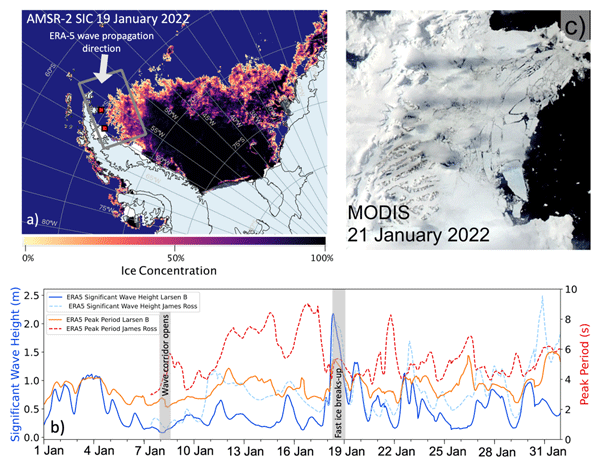
On the Antarctic Peninsula, there is a small bay that had sea ice fastened to the shoreline (
fast ice) for over a decade. The fast ice stabilized the glaciers that fed into the ocean. In January 2022, the fast ice broke away. Using satellite data we found that this was because of low sea ice concentrations and a high long-period ocean wave swell. We find that the glaciers have responded to this event by thinning, speeding up, and retreating by breaking off lots of icebergs at remarkable rates.
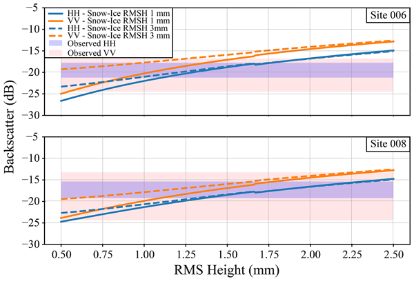
Justin Murfitt, Claude Duguay, Ghislain Picard, and Juha Lemmetyinen
The Cryosphere, 18, 869–888, https://doi.org/10.5194/tc-18-869-2024, https://doi.org/10.5194/tc-18-869-2024, 2024
Short summary
Short summary
This research focuses on the interaction between microwave signals and lake ice under wet conditions. Field data collected for Lake Oulujärvi in Finland were used to model backscatter under different conditions. The results of the modelling likely indicate that a combination of increased water content and roughness of different interfaces caused backscatter to increase. These results could help to identify areas where lake ice is unsafe for winter transportation.
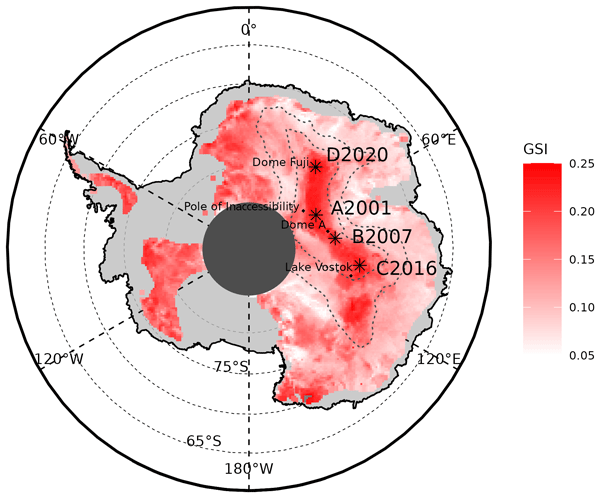
Claudio Stefanini, Giovanni Macelloni, Marion Leduc-Leballeur, Vincent Favier, Benjamin Pohl, and Ghislain Picard
The Cryosphere, 18, 593–608, https://doi.org/10.5194/tc-18-593-2024, https://doi.org/10.5194/tc-18-593-2024, 2024
Short summary
Short summary
Local and large-scale meteorological conditions have been considered in order to explain some peculiar changes of snow grains on the East Antarctic Plateau from 2000 to 2022, by using remote sensing observations and reanalysis. We identified some extreme grain size events on the highest ice divide, resulting from a combination of conditions of low wind speed and low temperature. Moreover, the beginning of seasonal grain growth has been linked to the occurrence of atmospheric rivers.
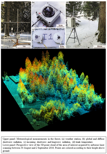
Jean Emmanuel Sicart, Victor Ramseyer, Ghislain Picard, Laurent Arnaud, Catherine Coulaud, Guilhem Freche, Damien Soubeyrand, Yves Lejeune, Marie Dumont, Isabelle Gouttevin, Erwan Le Gac, Frédéric Berger, Jean-Matthieu Monnet, Laurent Borgniet, Éric Mermin, Nick Rutter, Clare Webster, and Richard Essery
Earth Syst. Sci. Data, 15, 5121–5133, https://doi.org/10.5194/essd-15-5121-2023, https://doi.org/10.5194/essd-15-5121-2023, 2023
Short summary
Short summary
Forests strongly modify the accumulation, metamorphism and melting of snow in midlatitude and high-latitude regions. Two field campaigns during the winters 2016–17 and 2017–18 were conducted in a coniferous forest in the French Alps to study interactions between snow and vegetation. This paper presents the field site, instrumentation and collection methods. The observations include forest characteristics, meteorology, snow cover and snow interception by the canopy during precipitation events.
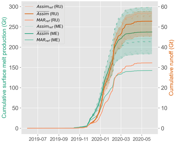
Thomas Dethinne, Quentin Glaude, Ghislain Picard, Christoph Kittel, Patrick Alexander, Anne Orban, and Xavier Fettweis
The Cryosphere, 17, 4267–4288, https://doi.org/10.5194/tc-17-4267-2023, https://doi.org/10.5194/tc-17-4267-2023, 2023
Short summary
Short summary
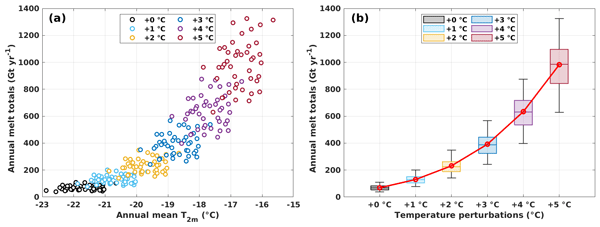
We investigate the sensitivity of the regional climate model
Modèle Atmosphérique Régional(MAR) to the assimilation of wet-snow occurrence estimated by remote sensing datasets. The assimilation is performed by nudging the MAR snowpack temperature. The data assimilation is performed over the Antarctic Peninsula for the 2019–2021 period. The results show an increase in the melt production (+66.7 %) and a decrease in surface mass balance (−4.5 %) of the model for the 2019–2020 melt season.
Yaowen Zheng, Nicholas R. Golledge, Alexandra Gossart, Ghislain Picard, and Marion Leduc-Leballeur
The Cryosphere, 17, 3667–3694, https://doi.org/10.5194/tc-17-3667-2023, https://doi.org/10.5194/tc-17-3667-2023, 2023
Short summary
Short summary
Positive degree-day (PDD) schemes are widely used in many Antarctic numerical ice sheet models. However, the PDD approach has not been systematically explored for its application in Antarctica. We have constructed a novel grid-cell-level spatially distributed PDD (dist-PDD) model and assessed its accuracy. We suggest that an appropriately parameterized dist-PDD model can be a valuable tool for exploring Antarctic surface melt beyond the satellite era.
Esteban Alonso-González, Simon Gascoin, Sara Arioli, and Ghislain Picard
The Cryosphere, 17, 3329–3342, https://doi.org/10.5194/tc-17-3329-2023, https://doi.org/10.5194/tc-17-3329-2023, 2023
Short summary
Short summary
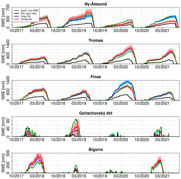
Data assimilation techniques are a promising approach to improve snowpack simulations in remote areas that are difficult to monitor. This paper studies the ability of satellite-observed land surface temperature to improve snowpack simulations through data assimilation. We show that it is possible to improve snowpack simulations, but the temporal resolution of the observations and the algorithm used are critical to obtain satisfactory results.
Sara Arioli, Ghislain Picard, Laurent Arnaud, and Vincent Favier
The Cryosphere, 17, 2323–2342, https://doi.org/10.5194/tc-17-2323-2023, https://doi.org/10.5194/tc-17-2323-2023, 2023
Short summary
Short summary
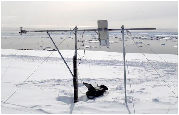
To assess the drivers of the snow grain size evolution during snow drift, we exploit a 5-year time series of the snow grain size retrieved from spectral-albedo observations made with a new, autonomous, multi-band radiometer and compare it to observations of snow drift, snowfall and snowmelt at a windy location of coastal Antarctica. Our results highlight the complexity of the grain size evolution in the presence of snow drift and show an overall tendency of snow drift to limit its variations.
Ghislain Picard, Marion Leduc-Leballeur, Alison F. Banwell, Ludovic Brucker, and Giovanni Macelloni
The Cryosphere, 16, 5061–5083, https://doi.org/10.5194/tc-16-5061-2022, https://doi.org/10.5194/tc-16-5061-2022, 2022
Short summary
Short summary
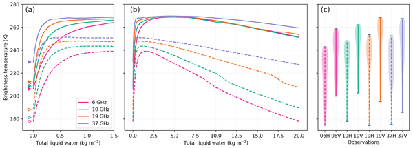
Using a snowpack radiative transfer model, we investigate in which conditions meltwater can be detected from passive microwave satellite observations from 1.4 to 37 GHz. In particular, we determine the minimum detectable liquid water content, the maximum depth of detection of a buried wet snow layer and the risk of false alarm due to supraglacial lakes. These results provide information for the developers of new, more advanced satellite melt products and for the users of the existing products.
Dominic Saunderson, Andrew Mackintosh, Felicity McCormack, Richard Selwyn Jones, and Ghislain Picard
The Cryosphere, 16, 4553–4569, https://doi.org/10.5194/tc-16-4553-2022, https://doi.org/10.5194/tc-16-4553-2022, 2022
Short summary
Short summary
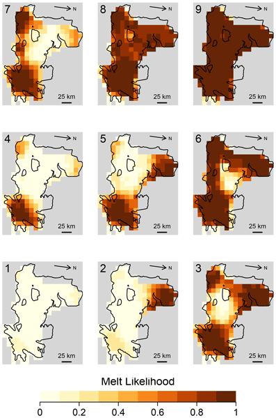
We investigate the variability in surface melt on the Shackleton Ice Shelf in East Antarctica over the last 2 decades (2003–2021). Using daily satellite observations and the machine learning approach of a self-organising map, we identify nine distinct spatial patterns of melt. These patterns allow comparisons of melt within and across melt seasons and highlight the importance of both air temperatures and local controls such as topography, katabatic winds, and albedo in driving surface melt.

Ghislain Picard, Henning Löwe, and Christian Mätzler
The Cryosphere, 16, 3861–3866, https://doi.org/10.5194/tc-16-3861-2022, https://doi.org/10.5194/tc-16-3861-2022, 2022
Short summary
Short summary
Microwave satellite observations used to monitor the cryosphere require radiative transfer models for their interpretation. These models represent how microwaves are scattered by snow and ice. However no existing theory is suitable for all types of snow and ice found on Earth. We adapted a recently published generic scattering theory to snow and show how it may improve the representation of snows with intermediate densities (~500 kg/m3) and/or with coarse grains at high microwave frequencies.
Gauthier Vérin, Florent Domine, Marcel Babin, Ghislain Picard, and Laurent Arnaud
The Cryosphere, 16, 3431–3449, https://doi.org/10.5194/tc-16-3431-2022, https://doi.org/10.5194/tc-16-3431-2022, 2022
Short summary
Short summary
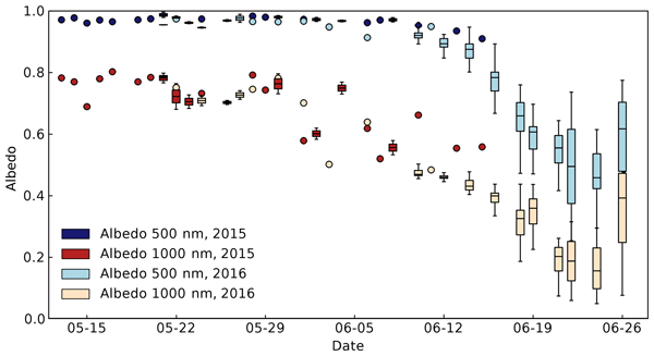
Snow physical properties on Arctic sea ice are monitored during the melt season. As snow grains grow, and the snowpack thickness is reduced, the surface albedo decreases. The extra absorbed energy accelerates melting. Radiative transfer modeling shows that more radiation is then transmitted to the snow–sea-ice interface. A sharp increase in transmitted radiation takes place when the snowpack thins significantly, and this coincides with the initiation of the phytoplankton bloom in the seawater.
Alvaro Robledano, Ghislain Picard, Laurent Arnaud, Fanny Larue, and Inès Ollivier
The Cryosphere, 16, 559–579, https://doi.org/10.5194/tc-16-559-2022, https://doi.org/10.5194/tc-16-559-2022, 2022
Short summary
Short summary
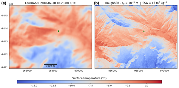
Topography controls the surface temperature of snow-covered, mountainous areas. We developed a modelling chain that uses ray-tracing methods to quantify the impact of a few topographic effects on snow surface temperature at high spatial resolution. Its large spatial and temporal variations are correctly simulated over a 50 km2 area in the French Alps, and our results show that excluding a single topographic effect results in cooling (or warming) effects on the order of 1 °C.
Maria Belke-Brea, Florent Domine, Ghislain Picard, Mathieu Barrere, and Laurent Arnaud
Biogeosciences, 18, 5851–5869, https://doi.org/10.5194/bg-18-5851-2021, https://doi.org/10.5194/bg-18-5851-2021, 2021
Short summary
Short summary
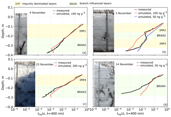
Expanding shrubs in the Arctic change snowpacks into a mix of snow, impurities and buried branches. Snow is a translucent medium into which light penetrates and gets partly absorbed by branches or impurities. Measurements of light attenuation in snow in Northern Quebec, Canada, showed (1) black-carbon-dominated light attenuation in snowpacks without shrubs and (2) buried branches influence radiation attenuation in snow locally, leading to melting and pockets of large crystals close to branches.
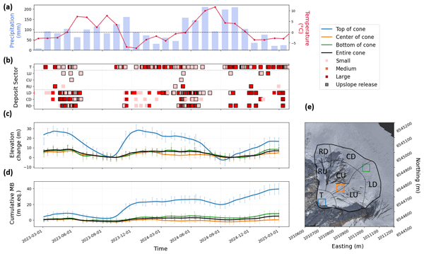
Marin Kneib, Patrick Wagnon, Laurent Arnaud, Louise Balmas, Olivier Laarman, Bruno Jourdain, Amaury Dehecq, Emmanuel Lemeur, Fanny Brun, Andrea Kneib-Walter, Ilaria Santin, Laurane Charrier, Thierry Faug, Giulia Mazzotti, Antoine Rabatel, Delphine Six, and Daniel Farinotti
The Cryosphere, 20, 5327–5344, https://doi.org/10.5194/tc-20-5327-2026, https://doi.org/10.5194/tc-20-5327-2026, 2026
Short summary
Short summary
Avalanches are vital for glacier survival, yet their impact is difficult to quantify. We used low-cost cameras and drones to monitor an avalanche cone in the French Alps for two years. By accounting for ice flow, we found that avalanches can deposit 30 meters of snow annually – 50 times more than normal snowfall. This high-frequency data reveals that these cones fill until reaching a specific steepness, after which new snow slides further down to the base.
Ayush Prasad, Ioanna Merkouriadi, Aleksi Nummelin, Jack Landy, Arttu Jutila, and Glen E. Liston
EGUsphere, https://doi.org/10.5194/egusphere-2026-4727, https://doi.org/10.5194/egusphere-2026-4727, 2026
Short summary
Short summary
Snow on Arctic sea ice is blown by wind into uneven drifts around ridges, which affects how well we can measure the thickness of the ice from satellites. Numerical models can capture this but are far too slow to run across the whole Arctic. We trained a machine-learning model on detailed simulations of small patches of ice, then applied it across the Arctic using satellite measurements of how rough the ice surface is.
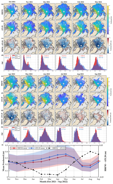
Wenxuan Liu, Ruibo Lei, Taoyong Jin, Heyang Sun, Michel Tsamados, Isolde A. Glissenaar, Jack Christopher Landy, and Yi Zhou
The Cryosphere, 20, 4839–4876, https://doi.org/10.5194/tc-20-4839-2026, https://doi.org/10.5194/tc-20-4839-2026, 2026
Short summary
Short summary
Arctic sea ice is thinning, but its height above the ocean is still hard to measure, especially in summer when melt ponds can look like open water from space. We developed a method that uses laser measurements from the Ice, Cloud, and land Elevation Satellite-2 and nearby satellite images to better separate ice from open water. It captures small ridges more clearly, improves lead detection, and provides year-round freeboard maps that can support better estimates of ice thickness.
Adrien Ooms, Mathieu Casado, Sonja Wahl, Thomas Laepple, Alexandra Zuhr, Pete Akers, Ghislain Picard, Laurent Arnaud, Joel Savarino, Kira Rehfeld, Barbara Stenni, Giuliano Dreossi, Mauro Masiol, Amaelle Landais, and Valérie Masson-Delmotte
EGUsphere, https://doi.org/10.5194/egusphere-2026-4801, https://doi.org/10.5194/egusphere-2026-4801, 2026
This preprint is open for discussion and under review for Climate of the Past (CP).
Short summary
Short summary
This work presents new insights in the archival process of multi-annual climatic signal in the near surface firn at Concordia Station, East-Antarctica, from the new data set of high resolution stable water isotope profiles measured in a snow trench. The dated isotopic profiles covering 20 years are compared against overlapping precipitation and surface snow observations. This highlights the strong contribution of stratigraphic noise and post depositional effects to individual trench profiles.
Jaya Sree Mugunthan, Claude R. Duguay, Justin Murfitt, Elena Zakharova, and Benjamin M. Jones
EGUsphere, https://doi.org/10.5194/egusphere-2026-4309, https://doi.org/10.5194/egusphere-2026-4309, 2026
This preprint is open for discussion and under review for The Cryosphere (TC).
Short summary
Short summary
This paper explores how the new Surface Water and Ocean Topography (SWOT) satellite can improve monitoring of lake ice and seasonal changes in cold regions. Although SWOT observes water surfaces worldwide, how its measurements respond to frozen lakes is not yet well understood. We show that these observations can reveal important ice features, freeze–melt transitions, and changes in snow and ice conditions. The results provide new opportunities for monitoring frozen freshwater environments.
Marta Stentella, Ghislain Picard, Petra Heil, Jacqueline Boutin, Emmanuel Dinnat, and Stuart Corney
The Cryosphere, 20, 4465–4489, https://doi.org/10.5194/tc-20-4465-2026, https://doi.org/10.5194/tc-20-4465-2026, 2026
Short summary
Short summary
Passive microwave radiometers are the primary tool for monitoring Antarctic sea ice, but their reliability decreases in the marginal ice zone between the pack ice and the open ocean. We simulate satellite observations to assess the impact of varying physical parameters on sea ice concentration retrievals. The largest errors are due to flooded/wet snow, thin ice, and roughened ocean surfaces. These findings can improve our interpretation of satellite observations and forecast sea ice changes.
Philippe Gamet, Bimal K. Bhattacharya, Jean-Louis Roujean, Gilles Boulet, Corinne Salcedo, Albert Olioso, Kanishka Mallick, Marie Weiss, Emmanuelle Sarrazin, Emmanuelle Autret, Laure Roupioz, José Antonio Sobrino, Olivier Merlin, Ghislain Picard, Thomas H. G. Vidal, Mark Irvine, Rahul Nigam, Mehul Pandya, Simon Gascoin, Sébastien Marcq, Manoj K. Mishra, Emilie Delogu, Vincent Rivalland, Jordi Etchanchu, Jean-Louis Raynaud, Meenakshi Sarkar, Rishi K. Gangwar, Sushil K. Singh, Renaud Binet, Sara Arioli, Hervé Yésou, Isabelle Dadou, Alexei Kouraev, Julien Michel, Benoit Coudert, Samuel Mwangi, Nesrine Farhani, Ayan Das, Stéphane Saux-Picart, Thierry Tormos, Jean-François Piollé, Charles Verpoorter, Auline Rodler, Jonathan Leon Tavares, Jennifer Adams, Anand S. Sahadevan, Besavaraju Santhi Sree, Manikumar Vedantam, Dheeraj Adlakha, Laurence Buffet, Kathrin Naegeli, Itziar Barat, Jerome Demarty, Olivier Hagolle, and Philippe Maisongrande
EGUsphere, https://doi.org/10.5194/egusphere-2026-4492, https://doi.org/10.5194/egusphere-2026-4492, 2026
Short summary
Short summary
This paper highlights how the upcoming TRISHNA satellite mission (launching 2027) will transform Earth observation by providing high-resolution (60 m) thermal infrared imagery with sub-weekly revisits. It details the mission's design and its synergies with other future missions to significantly improve the monitoring of global surface temperature and its dynamics, water stress, and ecosystem energy processes.
Patrick C. Taylor, Armin Sorooshian, Rei Ueyama, Sebastian Schmidt, Ihab Abboud, Quincy Allison, Kevin Barry, Sebastian Becker, Holly A. Bender, Joseph R. Bennett, James B. Blair, Niklas Bohn, Linette Boisvert, Matthew D. Brown, Roelof Bruintjes, Anthony Bucholtz, Megan Buzanowicz, Brian Cairns, Filippo Calì Quaglia, Eduard Chemyakin, Bo Chen, Gao Chen, Hong Chen, Yu-Wen Chen, Zezhen Cheng, Swarup China, Dan Chirica, Yonghoon Choi, Peter Colarco, Brian Collister, Ewan Crosbie, Maurice J. Cross, Janet Daniels, Paul DeMott, Joshua P. DiGangi, Alcide Giorgio di Sarra, Glenn S. Diskin, Erica K. Dolinar, Eva-Lou Edwards, Samuel Ephraim, Nikolaos Evangeliou, Romanos Foskinis, Francesca Gallo, Lan Gao, José Luis Gómez-Amo, Daisy Gonzalez, Christine Groot Zwaaftink, Pawan Gupta, Ivan Heckman, Michael Hendrickson, Miguel Ricardo A. Hilario, Ken Hirata, Michelle Hofton, Andrew L. Holen, Ulas Im, Alia L. Khan, Ralph Kahn, Alexei V. Korolev, Sonia Kreidenweis, Thomas Krumpen, Nathan Kurtz, Leslie Lait, Bradley Lamkin, Jack Landy, Nurun Nahar Lata, Paul Lawson, Samuel LeBlanc, Sean Leavor, Jing Li, Thorsten Markus, Hal Maring, Andreas H. Massling, Camille Mavis, Flynn McGinnity, Kerry Meyer, Gabriel Mojica, Richard H. Moore, Parker Morris, Giovanni Muscari, Vikas Nataraja, Amin R. Nehrir, Athanasios Nenes, Edward P. Nowottnick, Matteo Ottaviani, Chelsea Parker, Ryan Patnaude, Michael Perez, Russell J. Perkins, Colten Peterson, Alek Petty, Stevie Phothisane, Chris Polashenski, Kerri A. Pratt, Kayla M. Preisler, John Prytherch, David Rabine, Jens Redemann, Ju-Mee Ryoo, Joseph S. Schlosser, Vanessa Selimovic, Michael A. Shook, Morgan Silverman, Henrik Skov, Alexander Smirnov, Cassidy Soloff, Amy Solomon, Snorre Stamnes, Azusa Takeishi, David R. Thompson, K. Lee Thornhill, Rachel Tilling, Michael Tjernström, Monica Tosco, Pedro C. Valdelomar, David Van Gilst, Jian Wang, Zhien Wang, Andrzej Wasilewski, Manfred Wendisch, Brent Wilder, Edward L. Winstead, Albert Wu, Peng Xian, Lauren M. Zamora, Jiaoshi Zhang, Lei Zhang, Lu Zhang, Luke Ziemba, and Paquita Zuidema
Earth Syst. Sci. Data Discuss., https://doi.org/10.5194/essd-2026-241, https://doi.org/10.5194/essd-2026-241, 2026
Preprint under review for ESSD
Short summary
Short summary
This article summarizes the data sets collected during the Arctic Radiation Cloud aerosol Sea ice Interaction eXperiment (ARCSIX), NASA's most comprehensive Arctic field campaign to date. The overarching goal was to quantify the contributions of surface, clouds, aerosol particles, and precipitation to summer sea ice melt. This paper describes the ARCSIX implementation including the flight strategy, instruments, complementary data sets, access, and usage details.
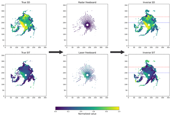
Elie René-Bazin, Michel Tsamados, Sabrina Sofea Binti Aliff Raziuddin, Joel Perez Ferrer, Tudor Suciu, Carmen Nab, Chamkaur Ghag, Harry Heorton, Rosemary Willatt, Jack Landy, Matthew Fox, and Thomas Bodin
The Cryosphere, 20, 3913–3932, https://doi.org/10.5194/tc-20-3913-2026, https://doi.org/10.5194/tc-20-3913-2026, 2026
Short summary
Short summary
This paper introduces a new statistical approach to retrieve ice and snow depth over the Arctic Ocean, using satellite altimeters measurements. We demonstrate the ability of this method to compute efficiently the sea ice thickness and the snow depth over the Arctic, without major assumptions on the snow. In addition to the ice and snow depth, this approach is efficient to study the penetration of radar and laser pulses, paving the way for further research in satellite altimetry.
Julien Meloche, Melody Sandells, Henning Löwe, Nick Rutter, Ghislain Picard, Richard Essery, Randall K. Scharien, Alexandre Langlois, Matthias Jaggi, Josh King, Peter Toose, Michele Scagliola, Jerome Bouffard, Alessandro Di Bella, and Christian Haas
EGUsphere, https://doi.org/10.5194/egusphere-2026-3615, https://doi.org/10.5194/egusphere-2026-3615, 2026
Short summary
Short summary
Sea ice thickness is essential for climate studies. Radar altimetry has provided sea ice thickness measurements, but uncertainty arises from the interaction of the signal with the snow cover. Therefore, modelling the signal interaction with the snow is necessary to improve retrieval. A radar model was used to simulate the radar signal from the snow-covered sea ice. This work paved the way to improved physical algorithms to retrieve snow depth and sea ice thickness for radar altimeter missions.
Adrien Ooms, Mathieu Casado, Ghislain Picard, Laurent Arnaud, Maria Hörhold, Andrea Spolaor, Rita Traversi, Joel Savarino, Patrick Ginot, Pete Akers, Birthe Twarloh, and Valérie Masson-Delmotte
The Cryosphere, 20, 3235–3255, https://doi.org/10.5194/tc-20-3235-2026, https://doi.org/10.5194/tc-20-3235-2026, 2026
Short summary
Short summary
This work presents a new approach to the estimation of accumulation rates at Concordia Station, East-Antarctica, for the last 20 years, from a new data set of chemical tracers and snow micro-scale properties measured in a snow trench. Multi-annual and meter to decameter scale variability of accumulation rates are compared again in-situ measurements of surface laser scanner and stake farm, with very good agreement. This further constrains SMB estimation for Antarctica at high temporal resolution.
Catherine Taelman, Jack Landy, Robbie Mallett, and Polona Itkin
EGUsphere, https://doi.org/10.5194/egusphere-2026-1662, https://doi.org/10.5194/egusphere-2026-1662, 2026
Short summary
Short summary
Arctic sea ice thickness is commonly estimated using radar measurements from satellites. This technique assumes that the snow on sea ice is 'invisible' to the radar signals. We studied if this assumption is valid and found that the radar measurements work well in cold conditions, when air temperatures are below –10 °C. However, the radar measurements can overestimate ice thickness during warmer periods, especially if there is new snowfall and if the snow contains salt.
Titouan Tcheng, Elise Fourré, Christophe Leroy-Dos Santos, Frédéric Parrenin, Emmanuel Le Meur, Frédéric Prié, Olivier Jossoud, Roxanne Jacob, Bénédicte Minster, Olivier Magand, Cécile Agosta, Niels Dutrievoz, Vincent Favier, Léa Baubant, Coralie Lassalle-Bernard, Mathieu Casado, Martin Werner, Alexandre Cauquoin, Laurent Arnaud, Bruno Jourdain, Ghislain Picard, Marie Bouchet, and Amaëlle Landais
The Cryosphere, 20, 1599–1618, https://doi.org/10.5194/tc-20-1599-2026, https://doi.org/10.5194/tc-20-1599-2026, 2026
Short summary
Short summary
Studying Antarctic ice cores is crucial to assess past climate changes, as they hold historical climate data. This study examines multiple ice cores from three sites in coastal Adélie Land to see if combining cores improves data interpretability. It does at two sites, but at a third, wind-driven snow layer mixing limited benefits. We show that using multiple ice cores from one location can better uncover climate history, especially in areas with less wind disturbance.
Samuel J. Johnston, Justin Murfitt, and Claude Duguay
EGUsphere, https://doi.org/10.5194/egusphere-2025-5576, https://doi.org/10.5194/egusphere-2025-5576, 2026
Short summary
Short summary
The Lake Ice Forecasting using Deep Learning model produces spatially explicit forecasts, which consistently outperform the popular Freshwater Lake model. Freeze-up and break-up timing was improved to within 3–9 days with greatly enhanced spatial accuracy of forecasted ice cover patterns. This establishes the potential of data-driven methods to advance lake ice models, with implications for enhancing weather prediction, northern transportation planning, and climate change adaptation.
Nicholas Williams, Nicholas Byrne, Daniel Feltham, Peter Jan Van Leeuwen, Ross Bannister, David Schroeder, Isobel Lawrence, Lars Nerger, Jack Landy, and Geoffrey Dawson
EGUsphere, https://doi.org/10.5194/egusphere-2026-742, https://doi.org/10.5194/egusphere-2026-742, 2026
Short summary
Short summary
In this study we present three satellite era Arctic sea ice reanalyses, each assimilating different combinations of sea ice concentration and thickness observations. Results show that using year-round thickness observations substantially improves reanalysis compared to winter-only data. The best-performing reanalysis reveals a seasonally compensating bias cycle, suggesting errors in ice growth, leads, refreezing, marginal ice zone dynamics, redistribution, and melt timing mask model errors.
Léa Elise Bonnefoy, Catherine Prigent, Ghislain Picard, Clément Soriot, Alice Le Gall, Lise Kilic, and Carlos Jimenez
The Cryosphere, 20, 1297–1314, https://doi.org/10.5194/tc-20-1297-2026, https://doi.org/10.5194/tc-20-1297-2026, 2026
Short summary
Short summary
Microwave radiometry senses the thermal emission from a target, whereas its active counterpart, radar, sends a signal to the target and measures the reflected signal. We simultaneously model radar and radiometry over the East Antarctic ice sheet, which we propose as an analog for icy moons: we can reproduce most data with a unique model. The radar response of Saturn's moons cannot be reproduced and is likely caused by processes unaccounted for in the model and less efficient in the Antarctic.
Marion Leduc-Leballeur, Ghislain Picard, Pierre Zeiger, and Giovanni Macelloni
The Cryosphere, 20, 1199–1216, https://doi.org/10.5194/tc-20-1199-2026, https://doi.org/10.5194/tc-20-1199-2026, 2026
Short summary
Short summary
This study presents a quantitative and synthetic classification of the snowpack in 10 dry-wet status by aggregating separate binary indicators derived from satellite observations. The classification follows the expected evolution of the melt season: night refreezing is frequent at the onset, sustained melting is observed during the summer peak, and remnant liquid water at depth occurs at the end. This dataset improves the knowledge of melt processes using passive microwave remote sensing.
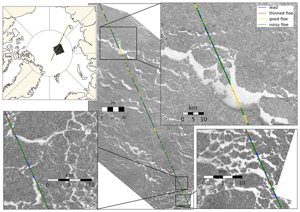
Anne Braakmann-Folgmann, Jack C. Landy, Geoffrey Dawson, and Robert Ricker
The Cryosphere, 20, 905–929, https://doi.org/10.5194/tc-20-905-2026, https://doi.org/10.5194/tc-20-905-2026, 2026
Short summary
Short summary
To calculate sea ice thickness from altimetry, returns from ice and leads need to be differentiated. During summer, melt ponds complicate this task, as they resemble leads. In this study, we improve a previously suggested neural network classifier by expanding the training dataset fivefold, tuning the network architecture and introducing an additional class for thinned floes. We show that this increases the accuracy from 77 ± 5 % to 84 ± 2 % and that more leads are found.
Valentin Ludwig, Caroline Ribere, Sara Fleury, Christian Haas, Michel Tsamados, Mahmoud El Hajj, Jerome Bouffard, Michele Scagliola, Marion Bocquet, Eric de Boisseson, Vincent Boulenger, Guillaume Boutin, Laurence Connor, Léo Edel, Stefan Hendricks, Ferran Hernández Macià, Marcus Huntemann, Lars Kaleschke, Frank Kauker, Jack Landy, Tom Megain, Alek Petty, Till Soya Rasmussen, Mads Hvid Ribergaard, Robert Ricker, Axel Schweiger, Hoyeon Shi, Xiangshan Tian-Kunze, Donghui Yi, and Alessandro Di Bella
EGUsphere, https://doi.org/10.5194/egusphere-2025-6201, https://doi.org/10.5194/egusphere-2025-6201, 2026
Short summary
Short summary
Our paper compares Arctic sea-ice thickness datasets from models, reanalyses, satellite-only, and multi-product sources. We validate them against Beaufort Sea reference data, compare large-scale products, and analyse time series. Cross-product biases range from 0.2–0.4 m, RMSDs from 0.4–0.9 m, and correlations from 0.5–0.8. We find no 2010–2023 trend, but 1995–2023 thinning of ~ 0.5 m in November and ~ 0.3 m in March.
Jack C. Landy, Claude de Rijke-Thomas, Carmen Nab, Isobel Lawrence, Isolde A. Glissenaar, Robbie D. C. Mallett, Renée M. Fredensborg Hansen, Alek Petty, Michel Tsamados, Amy R. Macfarlane, and Anne Braakmann-Folgmann
The Cryosphere, 20, 183–208, https://doi.org/10.5194/tc-20-183-2026, https://doi.org/10.5194/tc-20-183-2026, 2026
Short summary
Short summary
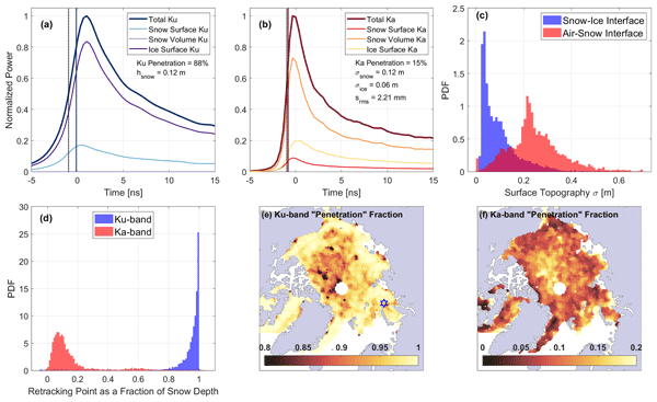
In this study, we use three satellites to test the planned remote sensing approach of the upcoming mission Copernicus Polar Ice and Snow Topography Altimeter (CRISTAL) over sea ice and that its dual radars will accurately measure the heights of the top and base of snow sitting atop floating sea ice floes. Our results suggest that CRISTAL's dual radars will not necessarily measure the snow top and base under all conditions. We find that accurate height measurements depend more on surface roughness than on snow properties, as is commonly assumed.
Stephen E. L. Howell, Alex Cabaj, David G. Babb, Jack C. Landy, Jackie Dawson, Mallik Mahmud, and Mike Brady
The Cryosphere, 19, 6711–6725, https://doi.org/10.5194/tc-19-6711-2025, https://doi.org/10.5194/tc-19-6711-2025, 2025
Short summary
Short summary
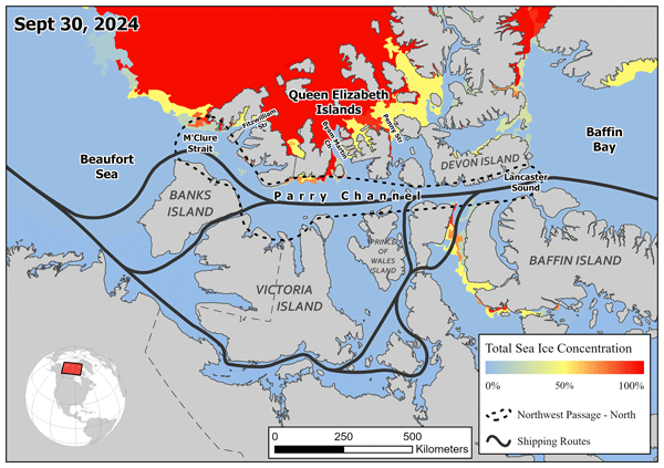
The Northwest Passage provides a shorter transit route connecting the Atlantic Ocean to the Pacific Ocean but ever-present sea ice has prevented its practical navigation. Sea ice area in the northern route of the Northwest Passage on September 30, 2024 fell to a minimum of 4×10³ km2 or ~3% of its total area, the lowest ice area observed since 1960. This paper describes the unique processes that contributed to the record low sea ice area in the northern route of the Northwest Passage in 2024.
Siqi Liu, Shiming Xu, Wenkai Guo, Yanfei Fan, Lu Zhou, Jack Landy, Malin Johansson, Weixin Zhu, and Alek Petty
The Cryosphere, 19, 5175–5199, https://doi.org/10.5194/tc-19-5175-2025, https://doi.org/10.5194/tc-19-5175-2025, 2025
Short summary
Short summary
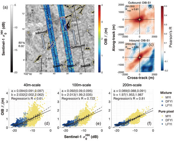
In this study, we explore the potential of using synthetic aperture radars (SAR) to predict the sea ice height measurements by the airborne campaign of Operation IceBridge. In particular, we predict the meter-scale sea ice height with the statistical relationship between the two, overcoming the resolution limitation of SAR images from Sentinel-1 satellites. The prediction and ice drift correction algorithms can be applied to the extrapolation of ICESat-2 measurements in the Arctic region.
Maya Raghunath Suryawanshi, Malcolm McMillan, Jennifer Maddalena, Fanny Piras, Jérémie Aublanc, Jean-Alexis Daguzé, Clara Grau, and Qi Huang
The Cryosphere, 19, 2855–2880, https://doi.org/10.5194/tc-19-2855-2025, https://doi.org/10.5194/tc-19-2855-2025, 2025
Short summary
Short summary
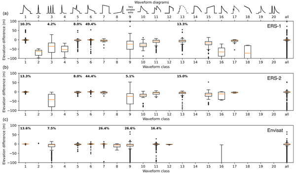
Increasing melting rates of the polar ice sheets are contributing more and more to sea level rise. Due to the remoteness and expanse of ice sheets, these changes are mainly observed using satellites. However, the accuracy of these measurements depends on the processing of these datasets. Here we use advanced algorithms to provide improved historical ice sheet elevation measurements, derived from satellite altimeters flying between 1991 and 2012, which will benefit cryospheric applications.

Jérémie Aublanc, François Boy, Franck Borde, and Pierre Féménias
The Cryosphere, 19, 1937–1954, https://doi.org/10.5194/tc-19-1937-2025, https://doi.org/10.5194/tc-19-1937-2025, 2025
Short summary
Short summary
In this study we developed a novel processing chain to derive the ice sheet topography from Sentinel-3 altimetry measurements (named "AMPLI"). The major innovation lies in the use of numerical simulations to geolocate the radar impact point on the ground. The performance improvement is substantial compared to ground segment processing. Furthermore, with AMPLI we show that Sentinel-3 estimates the surface elevation change of the Antarctic ice sheet with a high level of agreement with ICESat-2.
Florent Domine, Mireille Quémener, Ludovick Bégin, Benjamin Bouchard, Valérie Dionne, Sébastien Jerczynski, Raphaël Larouche, Félix Lévesque-Desrosiers, Simon-Olivier Philibert, Marc-André Vigneault, Ghislain Picard, and Daniel C. Côté
The Cryosphere, 19, 1757–1774, https://doi.org/10.5194/tc-19-1757-2025, https://doi.org/10.5194/tc-19-1757-2025, 2025
Short summary
Short summary
Shrubs buried in snow absorb solar radiation and reduce irradiance in the snowpack. This decreases photochemical reaction rates and emissions to the atmosphere. By monitoring irradiance in snowpacks with and without shrubs, we conclude that shrubs absorb solar radiation as much as 140 ppb of soot and reduce irradiance by a factor of 2. Shrub expansion in the Arctic may therefore affect tropospheric composition during the snow season with climatic effects.
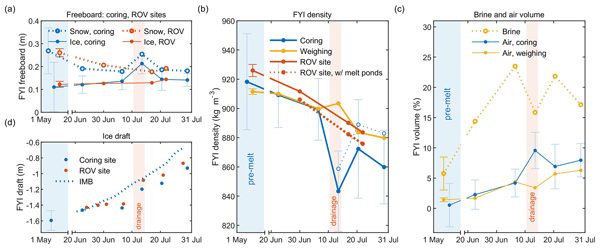
Evgenii Salganik, Odile Crabeck, Niels Fuchs, Nils Hutter, Philipp Anhaus, and Jack Christopher Landy
The Cryosphere, 19, 1259–1278, https://doi.org/10.5194/tc-19-1259-2025, https://doi.org/10.5194/tc-19-1259-2025, 2025
Short summary
Short summary
To measure Arctic ice thickness, we often check how much ice sticks out of the water. This method depends on knowing the ice's density, which drops significantly in summer. Our study, validated with sonar and laser data, shows that these seasonal changes in density can complicate melt measurements. We stress the importance of considering these density changes for more accurate ice thickness readings.
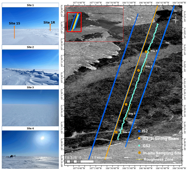
Monojit Saha, Julienne Stroeve, Dustin Isleifson, John Yackel, Vishnu Nandan, Jack Christopher Landy, and Hoi Ming Lam
The Cryosphere, 19, 325–346, https://doi.org/10.5194/tc-19-325-2025, https://doi.org/10.5194/tc-19-325-2025, 2025
Short summary
Short summary
Snow on sea ice is vital for near-shore sea ice geophysical and biological processes. Past studies have measured snow depths using the satellite altimeters Cryosat-2 and ICESat-2 (Cryo2Ice), but estimating sea surface height from leadless landfast sea ice remains challenging. Snow depths from Cryo2Ice are compared to in situ data after adjusting for tides. Realistic snow depths are retrieved, but differences in roughness, satellite footprints, and snow geophysical properties are identified.
Inès Ollivier, Hans Christian Steen-Larsen, Barbara Stenni, Laurent Arnaud, Mathieu Casado, Alexandre Cauquoin, Giuliano Dreossi, Christophe Genthon, Bénédicte Minster, Ghislain Picard, Martin Werner, and Amaëlle Landais
The Cryosphere, 19, 173–200, https://doi.org/10.5194/tc-19-173-2025, https://doi.org/10.5194/tc-19-173-2025, 2025
Short summary
Short summary
The role of post-depositional processes taking place at the ice sheet's surface on the water stable isotope signal measured in polar ice cores is not fully understood. Using field observations and modelling results, we show that the original precipitation isotopic signal at Dome C, East Antarctica, is modified by post-depositional processes and provide the first quantitative estimation of their mean impact on the isotopic signal observed in the snow.
Ghislain Picard and Quentin Libois
Geosci. Model Dev., 17, 8927–8953, https://doi.org/10.5194/gmd-17-8927-2024, https://doi.org/10.5194/gmd-17-8927-2024, 2024
Short summary
Short summary
The Two-streAm Radiative TransfEr in Snow (TARTES) is a radiative transfer model to compute snow albedo in the solar domain and the profiles of light and energy absorption in a multi-layered snowpack whose physical properties are user defined. It uniquely considers snow grain shape flexibly, based on recent insights showing that snow does not behave as a collection of ice spheres but instead as a random medium. TARTES is user-friendly yet performs comparably to more complex models.
Melody Sandells, Nick Rutter, Kirsty Wivell, Richard Essery, Stuart Fox, Chawn Harlow, Ghislain Picard, Alexandre Roy, Alain Royer, and Peter Toose
The Cryosphere, 18, 3971–3990, https://doi.org/10.5194/tc-18-3971-2024, https://doi.org/10.5194/tc-18-3971-2024, 2024
Short summary
Short summary
Satellite microwave observations are used for weather forecasting. In Arctic regions this is complicated by natural emission from snow. By simulating airborne observations from in situ measurements of snow, this study shows how snow properties affect the signal within the atmosphere. Fresh snowfall between flights changed airborne measurements. Good knowledge of snow layering and structure can be used to account for the effects of snow and could unlock these data to improve forecasts.
Sara Arioli, Ghislain Picard, Laurent Arnaud, Simon Gascoin, Esteban Alonso-González, Marine Poizat, and Mark Irvine
Earth Syst. Sci. Data, 16, 3913–3934, https://doi.org/10.5194/essd-16-3913-2024, https://doi.org/10.5194/essd-16-3913-2024, 2024
Short summary
Short summary
High-accuracy precision maps of the surface temperature of snow were acquired with an uncooled thermal-infrared camera during winter 2021–2022 and spring 2023. The accuracy – i.e., mean absolute error – improved from 1.28 K to 0.67 K between the seasons thanks to an improved camera setup and temperature stabilization. The dataset represents a major advance in the validation of satellite measurements and physical snow models over a complex topography.
Romilly Harris Stuart, Amaëlle Landais, Laurent Arnaud, Christo Buizert, Emilie Capron, Marie Dumont, Quentin Libois, Robert Mulvaney, Anaïs Orsi, Ghislain Picard, Frédéric Prié, Jeffrey Severinghaus, Barbara Stenni, and Patricia Martinerie
The Cryosphere, 18, 3741–3763, https://doi.org/10.5194/tc-18-3741-2024, https://doi.org/10.5194/tc-18-3741-2024, 2024
Short summary
Short summary
Ice core δO2/N2 records are useful dating tools due to their local insolation pacing. A precise understanding of the physical mechanism driving this relationship, however, remain ambiguous. By compiling data from 15 polar sites, we find a strong dependence of mean δO2/N2 on accumulation rate and temperature in addition to the well-documented insolation dependence. Snowpack modelling is used to investigate which physical properties drive the mechanistic dependence on these local parameters.
Julien Meloche, Melody Sandells, Henning Löwe, Nick Rutter, Richard Essery, Ghislain Picard, Randall K. Scharien, Alexandre Langlois, Matthias Jaggi, Josh King, Peter Toose, Jérôme Bouffard, Alessandro Di Bella, and Michele Scagliola
EGUsphere, https://doi.org/10.5194/egusphere-2024-1583, https://doi.org/10.5194/egusphere-2024-1583, 2024
Preprint archived
Short summary
Short summary
Sea ice thickness is essential for climate studies. Radar altimetry has provided sea ice thickness measurement, but uncertainty arises from interaction of the signal with the snow cover. Therefore, modelling the signal interaction with the snow is necessary to improve retrieval. A radar model was used to simulate the radar signal from the snow-covered sea ice. This work paved the way to improved physical algorithm to retrieve snow depth and sea ice thickness for radar altimeter missions.
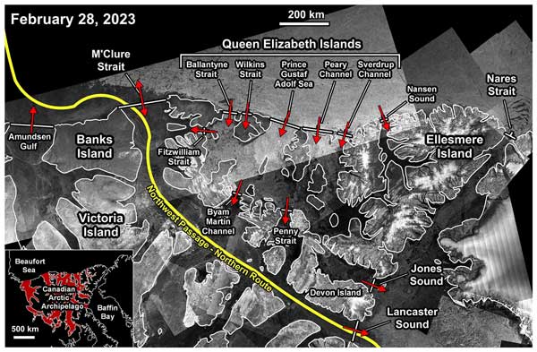
Stephen E. L. Howell, David G. Babb, Jack C. Landy, Isolde A. Glissenaar, Kaitlin McNeil, Benoit Montpetit, and Mike Brady
The Cryosphere, 18, 2321–2333, https://doi.org/10.5194/tc-18-2321-2024, https://doi.org/10.5194/tc-18-2321-2024, 2024
Short summary
Short summary
The CAA serves as both a source and a sink for sea ice from the Arctic Ocean, while also exporting sea ice into Baffin Bay. It is also an important region with respect to navigating the Northwest Passage. Here, we quantify sea ice transport and replenishment across and within the CAA from 2016 to 2022. We also provide the first estimates of the ice area and volume flux within the CAA from the Queen Elizabeth Islands to Parry Channel, which spans the central region of the Northwest Passage.
Naomi E. Ochwat, Ted A. Scambos, Alison F. Banwell, Robert S. Anderson, Michelle L. Maclennan, Ghislain Picard, Julia A. Shates, Sebastian Marinsek, Liliana Margonari, Martin Truffer, and Erin C. Pettit
The Cryosphere, 18, 1709–1731, https://doi.org/10.5194/tc-18-1709-2024, https://doi.org/10.5194/tc-18-1709-2024, 2024
Short summary
Short summary
On the Antarctic Peninsula, there is a small bay that had sea ice fastened to the shoreline (
fast ice) for over a decade. The fast ice stabilized the glaciers that fed into the ocean. In January 2022, the fast ice broke away. Using satellite data we found that this was because of low sea ice concentrations and a high long-period ocean wave swell. We find that the glaciers have responded to this event by thinning, speeding up, and retreating by breaking off lots of icebergs at remarkable rates.
Justin Murfitt, Claude Duguay, Ghislain Picard, and Juha Lemmetyinen
The Cryosphere, 18, 869–888, https://doi.org/10.5194/tc-18-869-2024, https://doi.org/10.5194/tc-18-869-2024, 2024
Short summary
Short summary
This research focuses on the interaction between microwave signals and lake ice under wet conditions. Field data collected for Lake Oulujärvi in Finland were used to model backscatter under different conditions. The results of the modelling likely indicate that a combination of increased water content and roughness of different interfaces caused backscatter to increase. These results could help to identify areas where lake ice is unsafe for winter transportation.
Claudio Stefanini, Giovanni Macelloni, Marion Leduc-Leballeur, Vincent Favier, Benjamin Pohl, and Ghislain Picard
The Cryosphere, 18, 593–608, https://doi.org/10.5194/tc-18-593-2024, https://doi.org/10.5194/tc-18-593-2024, 2024
Short summary
Short summary
Local and large-scale meteorological conditions have been considered in order to explain some peculiar changes of snow grains on the East Antarctic Plateau from 2000 to 2022, by using remote sensing observations and reanalysis. We identified some extreme grain size events on the highest ice divide, resulting from a combination of conditions of low wind speed and low temperature. Moreover, the beginning of seasonal grain growth has been linked to the occurrence of atmospheric rivers.
Jean Emmanuel Sicart, Victor Ramseyer, Ghislain Picard, Laurent Arnaud, Catherine Coulaud, Guilhem Freche, Damien Soubeyrand, Yves Lejeune, Marie Dumont, Isabelle Gouttevin, Erwan Le Gac, Frédéric Berger, Jean-Matthieu Monnet, Laurent Borgniet, Éric Mermin, Nick Rutter, Clare Webster, and Richard Essery
Earth Syst. Sci. Data, 15, 5121–5133, https://doi.org/10.5194/essd-15-5121-2023, https://doi.org/10.5194/essd-15-5121-2023, 2023
Short summary
Short summary
Forests strongly modify the accumulation, metamorphism and melting of snow in midlatitude and high-latitude regions. Two field campaigns during the winters 2016–17 and 2017–18 were conducted in a coniferous forest in the French Alps to study interactions between snow and vegetation. This paper presents the field site, instrumentation and collection methods. The observations include forest characteristics, meteorology, snow cover and snow interception by the canopy during precipitation events.
Thomas Dethinne, Quentin Glaude, Ghislain Picard, Christoph Kittel, Patrick Alexander, Anne Orban, and Xavier Fettweis
The Cryosphere, 17, 4267–4288, https://doi.org/10.5194/tc-17-4267-2023, https://doi.org/10.5194/tc-17-4267-2023, 2023
Short summary
Short summary
We investigate the sensitivity of the regional climate model
Modèle Atmosphérique Régional(MAR) to the assimilation of wet-snow occurrence estimated by remote sensing datasets. The assimilation is performed by nudging the MAR snowpack temperature. The data assimilation is performed over the Antarctic Peninsula for the 2019–2021 period. The results show an increase in the melt production (+66.7 %) and a decrease in surface mass balance (−4.5 %) of the model for the 2019–2020 melt season.
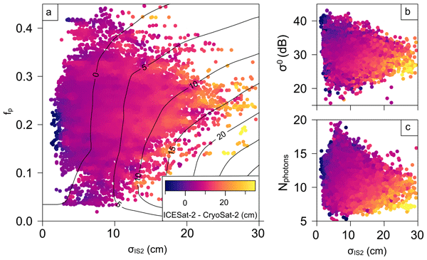
Geoffrey J. Dawson and Jack C. Landy
The Cryosphere, 17, 4165–4178, https://doi.org/10.5194/tc-17-4165-2023, https://doi.org/10.5194/tc-17-4165-2023, 2023
Short summary
Short summary
In this study, we compared measurements from CryoSat-2 and ICESat-2 over Arctic summer sea ice to understand any possible biases between the two satellites. We found that there is a difference when we measure elevation over summer sea ice using CryoSat-2 and ICESat-2, and this is likely due to surface melt ponds. The differences we found were in good agreement with theoretical predictions, and this work will be valuable for summer sea ice thickness measurements from both altimeters.
Yaowen Zheng, Nicholas R. Golledge, Alexandra Gossart, Ghislain Picard, and Marion Leduc-Leballeur
The Cryosphere, 17, 3667–3694, https://doi.org/10.5194/tc-17-3667-2023, https://doi.org/10.5194/tc-17-3667-2023, 2023
Short summary
Short summary
Positive degree-day (PDD) schemes are widely used in many Antarctic numerical ice sheet models. However, the PDD approach has not been systematically explored for its application in Antarctica. We have constructed a novel grid-cell-level spatially distributed PDD (dist-PDD) model and assessed its accuracy. We suggest that an appropriately parameterized dist-PDD model can be a valuable tool for exploring Antarctic surface melt beyond the satellite era.
Esteban Alonso-González, Simon Gascoin, Sara Arioli, and Ghislain Picard
The Cryosphere, 17, 3329–3342, https://doi.org/10.5194/tc-17-3329-2023, https://doi.org/10.5194/tc-17-3329-2023, 2023
Short summary
Short summary
Data assimilation techniques are a promising approach to improve snowpack simulations in remote areas that are difficult to monitor. This paper studies the ability of satellite-observed land surface temperature to improve snowpack simulations through data assimilation. We show that it is possible to improve snowpack simulations, but the temporal resolution of the observations and the algorithm used are critical to obtain satisfactory results.
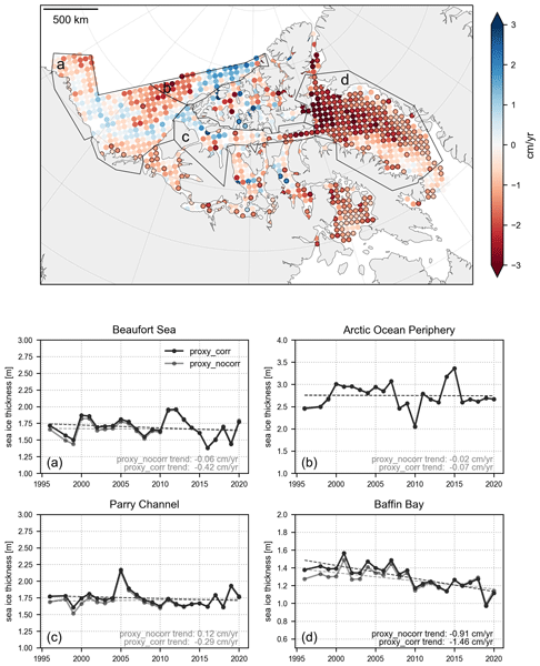
Isolde A. Glissenaar, Jack C. Landy, David G. Babb, Geoffrey J. Dawson, and Stephen E. L. Howell
The Cryosphere, 17, 3269–3289, https://doi.org/10.5194/tc-17-3269-2023, https://doi.org/10.5194/tc-17-3269-2023, 2023
Short summary
Short summary
Observations of large-scale ice thickness have unfortunately only been available since 2003, a short record for researching trends and variability. We generated a proxy for sea ice thickness in the Canadian Arctic for 1996–2020. This is the longest available record for large-scale sea ice thickness available to date and the first record reliably covering the channels between the islands in northern Canada. The product shows that sea ice has thinned by 21 cm over the 25-year record in April.
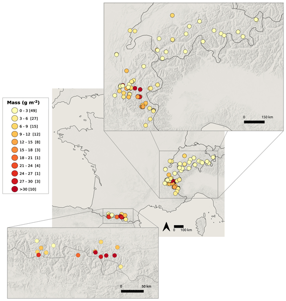
Marie Dumont, Simon Gascoin, Marion Réveillet, Didier Voisin, François Tuzet, Laurent Arnaud, Mylène Bonnefoy, Montse Bacardit Peñarroya, Carlo Carmagnola, Alexandre Deguine, Aurélie Diacre, Lukas Dürr, Olivier Evrard, Firmin Fontaine, Amaury Frankl, Mathieu Fructus, Laure Gandois, Isabelle Gouttevin, Abdelfateh Gherab, Pascal Hagenmuller, Sophia Hansson, Hervé Herbin, Béatrice Josse, Bruno Jourdain, Irene Lefevre, Gaël Le Roux, Quentin Libois, Lucie Liger, Samuel Morin, Denis Petitprez, Alvaro Robledano, Martin Schneebeli, Pascal Salze, Delphine Six, Emmanuel Thibert, Jürg Trachsel, Matthieu Vernay, Léo Viallon-Galinier, and Céline Voiron
Earth Syst. Sci. Data, 15, 3075–3094, https://doi.org/10.5194/essd-15-3075-2023, https://doi.org/10.5194/essd-15-3075-2023, 2023
Short summary
Short summary
Saharan dust outbreaks have profound effects on ecosystems, climate, health, and the cryosphere, but the spatial deposition pattern of Saharan dust is poorly known. Following the extreme dust deposition event of February 2021 across Europe, a citizen science campaign was launched to sample dust on snow over the Pyrenees and the European Alps. This campaign triggered wide interest and over 100 samples. The samples revealed the high variability of the dust properties within a single event.
Sara Arioli, Ghislain Picard, Laurent Arnaud, and Vincent Favier
The Cryosphere, 17, 2323–2342, https://doi.org/10.5194/tc-17-2323-2023, https://doi.org/10.5194/tc-17-2323-2023, 2023
Short summary
Short summary
To assess the drivers of the snow grain size evolution during snow drift, we exploit a 5-year time series of the snow grain size retrieved from spectral-albedo observations made with a new, autonomous, multi-band radiometer and compare it to observations of snow drift, snowfall and snowmelt at a windy location of coastal Antarctica. Our results highlight the complexity of the grain size evolution in the presence of snow drift and show an overall tendency of snow drift to limit its variations.

Vishnu Nandan, Rosemary Willatt, Robbie Mallett, Julienne Stroeve, Torsten Geldsetzer, Randall Scharien, Rasmus Tonboe, John Yackel, Jack Landy, David Clemens-Sewall, Arttu Jutila, David N. Wagner, Daniela Krampe, Marcus Huntemann, Mallik Mahmud, David Jensen, Thomas Newman, Stefan Hendricks, Gunnar Spreen, Amy Macfarlane, Martin Schneebeli, James Mead, Robert Ricker, Michael Gallagher, Claude Duguay, Ian Raphael, Chris Polashenski, Michel Tsamados, Ilkka Matero, and Mario Hoppmann
The Cryosphere, 17, 2211–2229, https://doi.org/10.5194/tc-17-2211-2023, https://doi.org/10.5194/tc-17-2211-2023, 2023
Short summary
Short summary
We show that wind redistributes snow on Arctic sea ice, and Ka- and Ku-band radar measurements detect both newly deposited snow and buried snow layers that can affect the accuracy of snow depth estimates on sea ice. Radar, laser, meteorological, and snow data were collected during the MOSAiC expedition. With frequent occurrence of storms in the Arctic, our results show that
wind-redistributed snow needs to be accounted for to improve snow depth estimates on sea ice from satellite radars.

Maria Shaposhnikova, Claude Duguay, and Pascale Roy-Léveillée
The Cryosphere, 17, 1697–1721, https://doi.org/10.5194/tc-17-1697-2023, https://doi.org/10.5194/tc-17-1697-2023, 2023
Short summary
Short summary
We explore lake ice in the Old Crow Flats, Yukon, Canada, using a novel approach that employs radar imagery and deep learning. Results indicate an 11 % increase in the fraction of lake ice that grounds between 1992/1993 and 2020/2021. We believe this is caused by widespread lake drainage and fluctuations in water level and snow depth. This transition is likely to have implications for permafrost beneath the lakes, with a potential impact on methane ebullition and the regional carbon budget.
Ghislain Picard, Marion Leduc-Leballeur, Alison F. Banwell, Ludovic Brucker, and Giovanni Macelloni
The Cryosphere, 16, 5061–5083, https://doi.org/10.5194/tc-16-5061-2022, https://doi.org/10.5194/tc-16-5061-2022, 2022
Short summary
Short summary
Using a snowpack radiative transfer model, we investigate in which conditions meltwater can be detected from passive microwave satellite observations from 1.4 to 37 GHz. In particular, we determine the minimum detectable liquid water content, the maximum depth of detection of a buried wet snow layer and the risk of false alarm due to supraglacial lakes. These results provide information for the developers of new, more advanced satellite melt products and for the users of the existing products.
Dominic Saunderson, Andrew Mackintosh, Felicity McCormack, Richard Selwyn Jones, and Ghislain Picard
The Cryosphere, 16, 4553–4569, https://doi.org/10.5194/tc-16-4553-2022, https://doi.org/10.5194/tc-16-4553-2022, 2022
Short summary
Short summary
We investigate the variability in surface melt on the Shackleton Ice Shelf in East Antarctica over the last 2 decades (2003–2021). Using daily satellite observations and the machine learning approach of a self-organising map, we identify nine distinct spatial patterns of melt. These patterns allow comparisons of melt within and across melt seasons and highlight the importance of both air temperatures and local controls such as topography, katabatic winds, and albedo in driving surface melt.
Ghislain Picard, Henning Löwe, and Christian Mätzler
The Cryosphere, 16, 3861–3866, https://doi.org/10.5194/tc-16-3861-2022, https://doi.org/10.5194/tc-16-3861-2022, 2022
Short summary
Short summary
Microwave satellite observations used to monitor the cryosphere require radiative transfer models for their interpretation. These models represent how microwaves are scattered by snow and ice. However no existing theory is suitable for all types of snow and ice found on Earth. We adapted a recently published generic scattering theory to snow and show how it may improve the representation of snows with intermediate densities (~500 kg/m3) and/or with coarse grains at high microwave frequencies.
Gauthier Vérin, Florent Domine, Marcel Babin, Ghislain Picard, and Laurent Arnaud
The Cryosphere, 16, 3431–3449, https://doi.org/10.5194/tc-16-3431-2022, https://doi.org/10.5194/tc-16-3431-2022, 2022
Short summary
Short summary
Snow physical properties on Arctic sea ice are monitored during the melt season. As snow grains grow, and the snowpack thickness is reduced, the surface albedo decreases. The extra absorbed energy accelerates melting. Radiative transfer modeling shows that more radiation is then transmitted to the snow–sea-ice interface. A sharp increase in transmitted radiation takes place when the snowpack thins significantly, and this coincides with the initiation of the phytoplankton bloom in the seawater.
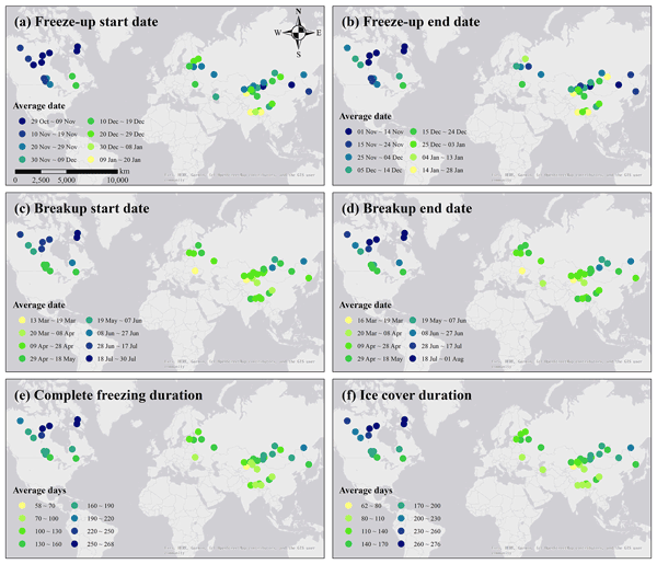
Yu Cai, Claude R. Duguay, and Chang-Qing Ke
Earth Syst. Sci. Data, 14, 3329–3347, https://doi.org/10.5194/essd-14-3329-2022, https://doi.org/10.5194/essd-14-3329-2022, 2022
Short summary
Short summary
Seasonal ice cover is one of the important attributes of lakes in middle- and high-latitude regions. This study used passive microwave brightness temperature measurements to extract the ice phenology for 56 lakes across the Northern Hemisphere from 1979 to 2019. A threshold algorithm was applied according to the differences in brightness temperature between lake ice and open water. The dataset will provide valuable information about the changing ice cover of lakes over the last 4 decades.
P. Zeiger, F. Frappart, and J. Darrozes
ISPRS Ann. Photogramm. Remote Sens. Spatial Inf. Sci., V-3-2022, 93–100, https://doi.org/10.5194/isprs-annals-V-3-2022-93-2022, https://doi.org/10.5194/isprs-annals-V-3-2022-93-2022, 2022
Alvaro Robledano, Ghislain Picard, Laurent Arnaud, Fanny Larue, and Inès Ollivier
The Cryosphere, 16, 559–579, https://doi.org/10.5194/tc-16-559-2022, https://doi.org/10.5194/tc-16-559-2022, 2022
Short summary
Short summary
Topography controls the surface temperature of snow-covered, mountainous areas. We developed a modelling chain that uses ray-tracing methods to quantify the impact of a few topographic effects on snow surface temperature at high spatial resolution. Its large spatial and temporal variations are correctly simulated over a 50 km2 area in the French Alps, and our results show that excluding a single topographic effect results in cooling (or warming) effects on the order of 1 °C.

Elena Zakharova, Svetlana Agafonova, Claude Duguay, Natalia Frolova, and Alexei Kouraev
The Cryosphere, 15, 5387–5407, https://doi.org/10.5194/tc-15-5387-2021, https://doi.org/10.5194/tc-15-5387-2021, 2021
Short summary
Short summary
The paper investigates the performance of altimetric satellite instruments to detect river ice onset and melting dates and to retrieve ice thickness of the Ob River. This is a first attempt to use satellite altimetry for monitoring ice in the challenging conditions restrained by the object size. A novel approach permitted elaboration of the spatiotemporal ice thickness product for the 400 km river reach. The potential of the product for prediction of ice road operation was demonstrated.
Maria Belke-Brea, Florent Domine, Ghislain Picard, Mathieu Barrere, and Laurent Arnaud
Biogeosciences, 18, 5851–5869, https://doi.org/10.5194/bg-18-5851-2021, https://doi.org/10.5194/bg-18-5851-2021, 2021
Short summary
Short summary
Expanding shrubs in the Arctic change snowpacks into a mix of snow, impurities and buried branches. Snow is a translucent medium into which light penetrates and gets partly absorbed by branches or impurities. Measurements of light attenuation in snow in Northern Quebec, Canada, showed (1) black-carbon-dominated light attenuation in snowpacks without shrubs and (2) buried branches influence radiation attenuation in snow locally, leading to melting and pockets of large crystals close to branches.
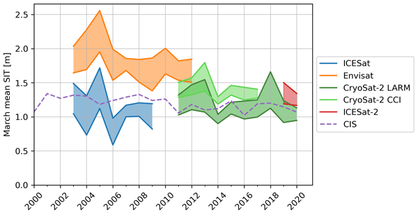
Isolde A. Glissenaar, Jack C. Landy, Alek A. Petty, Nathan T. Kurtz, and Julienne C. Stroeve
The Cryosphere, 15, 4909–4927, https://doi.org/10.5194/tc-15-4909-2021, https://doi.org/10.5194/tc-15-4909-2021, 2021
Short summary
Short summary
Scientists can estimate sea ice thickness using satellites that measure surface height. To determine the sea ice thickness, we also need to know the snow depth and density. This paper shows that the chosen snow depth product has a considerable impact on the findings of sea ice thickness state and trends in Baffin Bay, showing mean thinning with some snow depth products and mean thickening with others. This shows that it is important to better understand and monitor snow depth on sea ice.
Cited articles
Adams, R. and Brown, G.: A model for altimeter returns from penetrable geophysical media, IEEE T. Geosci. Remote, 36, 1784–1793, https://doi.org/10.1109/36.718645, 1998. a
Adodo, F. I., Remy, F., and Picard, G.: Seasonal variations of the backscattering coefficient measured by radar altimeters over the Antarctic Ice Sheet, The Cryosphere, 12, 1767–1778, https://doi.org/10.5194/tc-12-1767-2018, 2018. a
Amory, C., Naaim-Bouvet, F., Gallée, H., and Vignon, E.: Brief communication: Two well-marked cases of aerodynamic adjustment of sastrugi, The Cryosphere, 10, 743–750, https://doi.org/10.5194/tc-10-743-2016, 2016. a
Arnaud, L., Picard, G., Champollion, N., Domine, F., Gallet, J., Lefebvre, E., Fily, M., and Barnola, J.: Measurement of vertical profiles of snow specific surface area with a 1 cm resolution using infrared reflectance: instrument description and validation, J. Glaciol., 57, 17–29, https://doi.org/10.3189/002214311795306664, 2011. a
Aublanc, J., Moreau, T., Thibaut, P., Boy, F., Rémy, F., and Picot, N.: Evaluation of SAR altimetry over the antarctic ice sheet from CryoSat-2 acquisitions, Adv. Space Res., 62, 1307–1323, https://doi.org/10.1016/j.asr.2018.06.043, 2018. a
Aublanc, J., Renou, J., Piras, F., Nielsen, K., Rose, S. K., Simonsen, S. B., Fleury, S., Hendricks, S., Taburet, N., D'Apice, G., Chamayou, A., Féménias, P., Catapano, F., and Restano, M.: Sentinel-3 altimetry thematic products for hydrology, sea ice and land ice, Scientific Data, 12, https://doi.org/10.1038/s41597-025-04956-3, 2025b. a
Beckers, J. F., Alec Casey, J., and Haas, C.: Retrievals of lake ice thickness from Great Slave Lake and Great Bear Lake using CryoSat-2, IEEE T. Geosci. Remote, 55, 3708–3720, https://doi.org/10.1109/tgrs.2017.2677583, 2017. a
Bocquet, M., Fleury, S., Piras, F., Rinne, E., Sallila, H., Garnier, F., and Rémy, F.: Arctic sea ice radar freeboard retrieval from the European Remote-Sensing Satellite (ERS-2) using altimetry: toward sea ice thickness observation from 1995 to 2021, The Cryosphere, 17, 3013–3039, https://doi.org/10.5194/tc-17-3013-2023, 2023. a
Brenner, A. C., DiMarzio, J. P., and Zwally, H. J.: Precision and accuracy of satellite radar and laser altimeter data over the continental ice sheets, IEEE T. Geosci. Remote, 45, 321–331, https://doi.org/10.1109/tgrs.2006.887172, 2007. a
Brogioni, M., Pettinato, S., Macelloni, G., Paloscia, S., Pampaloni, P., Pierdicca, N., and Ticconi, F.: Sensitivity of bistatic scattering to soil moisture and surface roughness of bare soils, Int. J. Remote Sens., 31, 4227–4255, https://doi.org/10.1080/01431160903232808, 2010. a
Brucker, L., Picard, G., and Fily, M.: Snow grain size profiles deduced from microwave snow emissivities in Antarctica, J. Glaciol., 56, 514–526, https://doi.org/10.3189/002214310792447806, 2010. a
Buchhaupt, C. K., Egido, A., Vandemark, D., Smith, W. H. F., Fenoglio, L., and Leuliette, E.: Towards the mitigation of discrepancies in sea surface parameters estimated from low- and high-resolution satellite altimetry, Remote Sens.-Basel, 15, 4206, https://doi.org/10.3390/rs15174206, 2023. a
Buchhaupt, C., Egido, A., Dinardo, S., Maraldi, C., Moreau, T., and Fenoglio, L.: Impact of the antenna characteristics on sea surface parameters estimated from low- and high-resolution satellite altimetry, Adv. Space Res., 75, 6140–6157, https://doi.org/10.1016/j.asr.2025.02.056, 2025. a
Cazenave, A. and Nerem, R. S.: Present day sea level change: observations and causes, Rev. Geophys., 42, https://doi.org/10.1029/2003rg000139, 2004. a
Chelton, D. B., Walsh, E. J., and MacArthur, J. L.: Pulse compression and sea level tracking in satellite altimetry, J. Atmos. Ocean. Tech., 6, 407–438, https://doi.org/10.1175/1520-0426(1989)006<0407:pcaslt>2.0.co;2, 1989. a
Chen, K. S., Wu, T. D., Tsang, L., Li, Q., Shi, J., and Fung, A. K.: Emission of rough surfaces calculated by the integral equation method with comparison to three-dimensional moment method simulations, IEEE T. Geosci. Remote, 41, 90–101, https://doi.org/10.1109/TGRS.2002.807587, 2003. a, b
De Felice Proia, G., Restano, M., Comite, D., Clarizia, M. P., Benveniste, J., Pierdicca, N., and Guerriero, L.: An electromagnetic simulator for Sentinel-3 SAR altimeter waveforms over land – Part I: Bare soil, IEEE T. Geosci. Remote, 60, 1–11, https://doi.org/10.1109/tgrs.2022.3210720, 2022a. a, b, c, d, e, f
De Felice Proia, G., Restano, M., Comite, D., Clarizia, M. P., Benveniste, J., Pierdicca, N., and Guerriero, L.: An electromagnetic simulator for Sentinel-3 SAR altimeter waveforms over land – Part II: Forests, IEEE T. Geosci. Remote, 60, 1–10, https://doi.org/10.1109/tgrs.2022.3210722, 2022b. a, b, c
De Rijke-Thomas, C., Landy, J. C., Mallett, R., Willatt, R. C., Tsamados, M., and King, J.: Airborne investigation of quasi-specular Ku-Band radar scattering for satellite altimetry over snow-covered Arctic sea ice, IEEE T. Geosci. Remote, 61, 1–19, https://doi.org/10.1109/tgrs.2023.3318263, 2023. a, b
Donlon, C., Berruti, B., Buongiorno, A., Ferreira, M.-H., Féménias, P., Frerick, J., Goryl, P., Klein, U., Laur, H., Mavrocordatos, C., Nieke, J., Rebhan, H., Seitz, B., Stroede, J., and Sciarra, R.: The Global Monitoring for Environment and Security (GMES) Sentinel-3 mission, Remote Sens. Environ., 120, 37–57, https://doi.org/10.1016/j.rse.2011.07.024, 2012. a
Donlon, C. J., Cullen, R., Giulicchi, L., Vuilleumier, P., Francis, C. R., Kuschnerus, M., Simpson, W., Bouridah, A., Caleno, M., Bertoni, R., Rancaño, J., Pourier, E., Hyslop, A., Mulcahy, J., Knockaert, R., Hunter, C., Webb, A., Fornari, M., Vaze, P., Brown, S., Willis, J., Desai, S., Desjonqueres, J.-D., Scharroo, R., Martin-Puig, C., Leuliette, E., Egido, A., Smith, W. H., Bonnefond, P., Le Gac, S., Picot, N., and Tavernier, G.: The Copernicus Sentinel-6 mission: enhanced continuity of satellite sea level measurements from space, Remote Sens. Environ., 258, 112395, https://doi.org/10.1016/j.rse.2021.112395, 2021. a
Drinkwater, M. R.: Ku band airborne radar altimeter observations of marginal sea ice during the 1984 Marginal Ice Zone Experiment, J. Geophys. Res.-Oceans, 96, 4555–4572, https://doi.org/10.1029/90jc01954, 1991. a
Egido, A. and Smith, W. H. F.: Fully focused SAR altimetry: theory and applications, IEEE T. Geosci. Remote, 55, 392–406, https://doi.org/10.1109/tgrs.2016.2607122, 2017. a
Femenias, P., Remy, F., Raizonville, R., and Minster, J. F.: Analysis of satellite-altimeter height measurements above continental ice sheets, J. Glaciol., 39, 591–600, https://doi.org/10.3189/s0022143000016488, 1993. a
Fredensborg Hansen, R. M., Skourup, H., Rinne, E., Jutila, A., Lawrence, I. R., Shepherd, A., Høyland, K. V., Li, J., Rodriguez-Morales, F., Simonsen, S. B., Wilkinson, J., Veyssiere, G., Yi, D., Forsberg, R., and Casal, T. G. D.: Multi-frequency altimetry snow depth estimates over heterogeneous snow-covered Antarctic summer sea ice – Part 1: C/S-, Ku-, and Ka-band airborne observations, The Cryosphere, 19, 4167–4192, https://doi.org/10.5194/tc-19-4167-2025, 2025. a
Fung, A. K.: Microwave Scattering and Emission Models and their Applications, Remote Sensing Library, Artech House, Boston, USA, ISBN 9780890065235, 1994. a
Fung, A. and Eom, H.: Coherent scattering of a spherical wave from an irregular surface, IEEE T. Antenn. Propag., 31, 68–72, https://doi.org/10.1109/tap.1983.1142979, 1983. a, b
Gommenginger, C., Thibaut, P., Fenoglio-Marc, L., Quartly, G., Deng, X., Gómez-Enri, J., Challenor, P., and Gao, Y.: Retracking Altimeter Waveforms Near the Coasts: A Review of Retracking Methods and Some Applications to Coastal Waveforms, Springer Berlin Heidelberg, ISBN 9783642127960, https://doi.org/10.1007/978-3-642-12796-0_4, 61–101, 2010. a
Greengard, L., Lee, J.-Y., and Inati, S.: The fast sinc transform and image reconstruction from nonuniform samples in k-space, Comm. App. Math. Com. Sc., 1, 121–131, https://doi.org/10.2140/camcos.2006.1.121, 2006. a
Guerreiro, K., Fleury, S., Zakharova, E., Rémy, F., and Kouraev, A.: Potential for estimation of snow depth on Arctic sea ice from CryoSat-2 and SARAL/AltiKa missions, Remote Sens. Environ., 186, 339–349, https://doi.org/10.1016/j.rse.2016.07.013, 2016. a
Hagfors, T.: Remote probing of the moon by infrared and microwave emissions and by radar, Radio Sci., 5, 189–227, https://doi.org/10.1029/RS005i002p00189, 1970. a
Halimi, A., Mailhes, C., Tourneret, J.-Y., Boy, F., and Moreau, T.: Including antenna mispointing in a semi-analytical model for delay/Doppler altimetry, IEEE T. Geosci. Remote, 53, 598–608, https://doi.org/10.1109/tgrs.2014.2326177, 2015. a, b
Hamlington, B. D., Bellas-Manley, A., Willis, J. K., Fournier, S., Vinogradova, N., Nerem, R. S., Piecuch, C. G., Thompson, P. R., and Kopp, R.: The rate of global sea level rise doubled during the past three decades, Communications Earth Environment, 5, https://doi.org/10.1038/s43247-024-01761-5, 2024. a
Hernández-Burgos, S., Gibert, F., Broquetas, A., Kleinherenbrink, M., De la Cruz, A. F., Gómez-Olivé, A., García-Mondéjar, A., and i Aparici, M. R.: A fully focused SAR Omega-K closed-form algorithm for the Sentinel-6 radar altimeter: methodology and applications, IEEE T. Geosci. Remote, 62, 1–16, https://doi.org/10.1109/tgrs.2024.3367544, 2024. a
Howat, I., Porter, C., Noh, M.-J., Husby, E., Khuvis, S., Danish, E., Tomko, K., Gardiner, J., Negrete, A., Yadav, B., Klassen, J., Kelleher, C., Cloutier, M., Bakker, J., Enos, J., Arnold, G., Bauer, G., and Morin, P.: The Reference Elevation Model of Antarctica – Mosaics, Version 2, Harvard Dataverse [data set], https://doi.org/10.7910/DVN/EBW8UC, 2022. a
Huang, Q., McMillan, M., Muir, A., Phillips, J., and Slater, T.: Multipeak retracking of radar altimetry waveforms over ice sheets, Remote Sens. Environ., 303, 114020, https://doi.org/10.1016/j.rse.2024.114020, 2024. a
Kern, M., Cullen, R., Berruti, B., Bouffard, J., Casal, T., Drinkwater, M. R., Gabriele, A., Lecuyot, A., Ludwig, M., Midthassel, R., Navas Traver, I., Parrinello, T., Ressler, G., Andersson, E., Martin-Puig, C., Andersen, O., Bartsch, A., Farrell, S., Fleury, S., Gascoin, S., Guillot, A., Humbert, A., Rinne, E., Shepherd, A., van den Broeke, M. R., and Yackel, J.: The Copernicus Polar Ice and Snow Topography Altimeter (CRISTAL) high-priority candidate mission, The Cryosphere, 14, 2235–2251, https://doi.org/10.5194/tc-14-2235-2020, 2020. a, b, c, d
Kurtz, N. T., Galin, N., and Studinger, M.: An improved CryoSat-2 sea ice freeboard retrieval algorithm through the use of waveform fitting, The Cryosphere, 8, 1217–1237, https://doi.org/10.5194/tc-8-1217-2014, 2014. a, b, c
Kwok, R.: Simulated effects of a snow layer on retrieval of CryoSat 2 sea ice freeboard, Geophys. Res. Lett., 41, 5014–5020, https://doi.org/10.1002/2014gl060993, 2014. a
Lacroix, P., Legrésy, B., Langley, K., Hamran, S. E., Kohler, J., Roques, S., Rémy, F., and Dechambre, M.: In situ measurements of snow surface roughness using a laser profiler, J. Glaciol., 54, 753–762, https://doi.org/10.3189/002214308786570863, 2008. a, b, c
Landy, J.: jclandy/FBEM: FBEM_2022, Zenodo [code], https://doi.org/10.5281/ZENODO.6554739, 2022. a
Landy, J. C., Petty, A. A., Tsamados, M., and Stroeve, J. C.: Sea ice roughness overlooked as a key source of uncertainty in CryoSat 2 ice freeboard retrievals, J. Geophys. Res.-Oceans, 125, https://doi.org/10.1029/2019jc015820, 2020. a, b
Landy, J. C., Dawson, G. J., Tsamados, M., Bushuk, M., Stroeve, J. C., Howell, S. E. L., Krumpen, T., Babb, D. G., Komarov, A. S., Heorton, H. D. B. S., Belter, H. J., and Aksenov, Y.: A year-round satellite sea-ice thickness record from CryoSat-2, Nature, 609, 517–522, https://doi.org/10.1038/s41586-022-05058-5, 2022. a
Landy, J. C., de Rijke-Thomas, C., Nab, C., Lawrence, I., Glissenaar, I. A., Mallett, R. D. C., Fredensborg Hansen, R. M., Petty, A., Tsamados, M., Macfarlane, A. R., and Braakmann-Folgmann, A.: Anticipating CRISTAL: an exploration of multi-frequency satellite altimeter snow depth estimates over Arctic sea ice, 2018–2023, The Cryosphere, 20, 183–208, https://doi.org/10.5194/tc-20-183-2026, 2026. a
Larue, F., Picard, G., Aublanc, J., Arnaud, L., Robledano-Perez, A., Meur, E. L., Favier, V., Jourdain, B., Savarino, J., and Thibaut, P.: Radar altimeter waveform simulations in Antarctica with the Snow Microwave Radiative Transfer Model (SMRT), Remote Sens. Environ., 263, 112534, https://doi.org/10.1016/j.rse.2021.112534, 2021. a, b, c, d, e, f, g, h, i, j, k, l, m, n, o, p, q, r
Laxon, S. W., Giles, K. A., Ridout, A. L., Wingham, D. J., Willatt, R., Cullen, R., Kwok, R., Schweiger, A., Zhang, J., Haas, C., Hendricks, S., Krishfield, R., Kurtz, N., Farrell, S., and Davidson, M.: CryoSat 2 estimates of Arctic sea ice thickness and volume, Geophys. Res. Lett., 40, 732–737, https://doi.org/10.1002/grl.50193, 2013. a
MacArthur, J.: Design of the SEASAT-A Radar Altimeter, in: OCEANS'76, IEEE, https://doi.org/10.1109/oceans.1976.1154217, 1976. a
MacArthur, J.: Seasat, a radar altimeter design description, Rep. SDO-5232., Tech. rep., Applied Physics Lab, Johns Hopkins University, Baltimore, MD, 1978. a
Mangilli, A., Thibaut, P., Duguay, C. R., and Murfitt, J.: A new approach for the estimation of lake ice thickness from conventional radar altimetry, IEEE T. Geosci. Remote, 60, 1–15, https://doi.org/10.1109/tgrs.2022.3186253, 2022. a, b, c, d
Mangilli, A., Duguay, C. R., Murfitt, J., Moreau, T., Amraoui, S., Mugunthan, J. S., Thibaut, P., and Donlon, C.: Improving the estimation of lake ice thickness with high-resolution radar altimetry data, Remote Sens.-Basel, 16, 2510, https://doi.org/10.3390/rs16142510, 2024. a, b
McMillan, M., Muir, A., Shepherd, A., Escolà, R., Roca, M., Aublanc, J., Thibaut, P., Restano, M., Ambrozio, A., and Benveniste, J.: Sentinel-3 Delay-Doppler altimetry over Antarctica, The Cryosphere, 13, 709–722, https://doi.org/10.5194/tc-13-709-2019, 2019. a, b, c
Mie, G.: Beitraege zur Optik trueber Medien, speziell kolloidaler Metalloesungen, Ann. Phys., 330, 377–445, 1908. a
Murfitt, J., Duguay, C., Picard, G., and Gunn, G.: Forward modelling of synthetic aperture radar backscatter from lake ice over Canadian subarctic lakes, Remote Sens. Environ., 286, 113424, https://doi.org/10.1016/j.rse.2022.113424, 2023. a
Passaro, M., Nadzir, Z. A., and Quartly, G. D.: Improving the precision of sea level data from satellite altimetry with high-frequency and regional sea state bias corrections, Remote Sens. Environ., 218, 245–254, https://doi.org/10.1016/j.rse.2018.09.007, 2018. a
Picard, G.: Notebooks and data to compute microwave brightness temperature from microwave grain size and polydispersity, Zenodo [code], https://doi.org/10.5281/ZENODO.6519037, 2022. a
Picard, G.: smrt-model/smrt: SAR Altimetry, Zenodo [code], https://doi.org/10.5281/zenodo.22013342, 2026a. a, b
Picard, G.: ghislainp/sentinel3-sral-l2-at-vanish-asuma-eaiist-domec-sites: v0.9 (Version v0.9), Zenodo [code], https://doi.org/10.5281/zenodo.19231175, 2026b. a
Picard, G.: smrt-model/sar_altimetry_paper: Initial release Latest (Version 1.0), Zenodo [code], https://doi.org/10.5281/zenodo.22013144, 2026c. a
Picard, G., Sandells, M., and Löwe, H.: SMRT: an active–passive microwave radiative transfer model for snow with multiple microstructure and scattering formulations (v1.0), Geosci. Model Dev., 11, 2763–2788, https://doi.org/10.5194/gmd-11-2763-2018, 2018. a, b, c
Picard, G., Leduc-Leballeur, M., Banwell, A. F., Brucker, L., and Macelloni, G.: The sensitivity of satellite microwave observations to liquid water in the Antarctic snowpack, The Cryosphere, 16, 5061–5083, https://doi.org/10.5194/tc-16-5061-2022, 2022a. a
Picard, G., Löwe, H., Domine, F., Arnaud, L., Larue, F., Favier, V., Meur, E. L., Lefebvre, E., Savarino, J., and Royer, A.: The microwave snow grain size: a new concept to predict satellite observations over snow-covered regions, AGU Advances, 3, https://doi.org/10.1029/2021av000630, 2022b. a, b, c, d, e
Picard, G., Löwe, H., and Mätzler, C.: Brief communication: A continuous formulation of microwave scattering from fresh snow to bubbly ice from first principles, The Cryosphere, 16, 3861–3866, https://doi.org/10.5194/tc-16-3861-2022, 2022c. a, b, c
Poizat, M., Picard, G., Arnaud, L., Narteau, C., Amory, C., and Brun, F.: Widespread longitudinal snow dunes in Antarctica shaped by sintering, Nat. Geosci., 17, 889–895, https://doi.org/10.1038/s41561-024-01506-1, 2024. a
Raynal, M., Labroue, S., Moreau, T., Boy, F., and Picot, N.: From conventional to Delay Doppler altimetry: a demonstration of continuity and improvements with the Cryosat-2 mission, Adv. Space Res., 62, 1564–1575, https://doi.org/10.1016/j.asr.2018.01.006, 2018. a
Remy, F., Flament, T., Blarel, F., and Benveniste, J.: Radar altimetry measurements over antarctic ice sheet: a focus on antenna polarization and change in backscatter problems, Adv. Space Res., 50, 998–1006, https://doi.org/10.1016/j.asr.2012.04.003, 2012. a, b
Ricker, R., Hendricks, S., Helm, V., Skourup, H., and Davidson, M.: Sensitivity of CryoSat-2 Arctic sea-ice freeboard and thickness on radar-waveform interpretation, The Cryosphere, 8, 1607–1622, https://doi.org/10.5194/tc-8-1607-2014, 2014. a
Ridley, J. K., Cudlip, W., and Laxon, S. W.: Identification of subglacial lakes using ERS-1 radar altimeter, J. Glaciol., 39, 625–634, https://doi.org/10.3189/s002214300001652x, 1993. a
Rosen, P., Hensley, S., Joughin, I., Li, F., Madsen, S., Rodriguez, E., and Goldstein, R.: Synthetic aperture radar interferometry, P. IEEE, 88, 333–382, https://doi.org/10.1109/5.838084, 2000. a
Sandberg Sørensen, L., Simonsen, S. B., Forsberg, R., Khvorostovsky, K., Meister, R., and Engdahl, M. E.: 25 years of elevation changes of the Greenland Ice Sheet from ERS, Envisat, and CryoSat-2 radar altimetry, Earth Planet. Sc. Lett., 495, 234–241, https://doi.org/10.1016/j.epsl.2018.05.015, 2018. a
Sandberg Sørensen, L., Bahbah, R., Simonsen, S. B., Havelund Andersen, N., Bowling, J., Gourmelen, N., Horton, A., Karlsson, N. B., Leeson, A., Maddalena, J., McMillan, M., Solgaard, A., and Wessel, B.: Improved monitoring of subglacial lake activity in Greenland, The Cryosphere, 18, 505–523, https://doi.org/10.5194/tc-18-505-2024, 2024. a
Sandells, M., Lowe, H., Picard, G., Dumont, M., Essery, R., Floury, N., Kontu, A., Lemmetyinen, J., Maslanka, W., Morin, S., Wiesmann, A., and Matzler, C.: X-ray tomography-based microstructure representation in the snow microwave radiative transfer model, IEEE T. Geosci. Remote, 1–15, https://doi.org/10.1109/tgrs.2021.3086412, 2021. a
Sandells, M., Rutter, N., Wivell, K., Essery, R., Fox, S., Harlow, C., Picard, G., Roy, A., Royer, A., and Toose, P.: Simulation of Arctic snow microwave emission in surface-sensitive atmosphere channels, The Cryosphere, 18, 3971–3990, https://doi.org/10.5194/tc-18-3971-2024, 2024. a
Shu, S., Liu, H., Beck, R. A., Frappart, F., Korhonen, J., Xu, M., Yang, B., Hinkel, K. M., Huang, Y., and Yu, B.: Analysis of Sentinel-3 SAR altimetry waveform retracking algorithms for deriving temporally consistent water levels over ice-covered lakes, Remote Sens. Environ., 239, 111643, https://doi.org/10.1016/j.rse.2020.111643, 2020. a
Slater, T., Shepherd, A., McMillan, M., Leeson, A., Gilbert, L., Muir, A., Munneke, P. K., Noël, B., Fettweis, X., van den Broeke, M., and Briggs, K.: Increased variability in Greenland Ice Sheet runoff from satellite observations, Nat. Commun., 12, https://doi.org/10.1038/s41467-021-26229-4, 2021. a
Stefanini, C., Macelloni, G., Leduc-Leballeur, M., Favier, V., Pohl, B., and Picard, G.: Extreme events of snow grain size increase in East Antarctica and their relationship with meteorological conditions, The Cryosphere, 18, 593–608, https://doi.org/10.5194/tc-18-593-2024, 2024. a
Studinger, M., Medley, B. C., Brunt, K. M., Casey, K. A., Kurtz, N. T., Manizade, S. S., Neumann, T. A., and Overly, T. B.: Temporal and spatial variability in surface roughness and accumulation rate around 88° S from repeat airborne geophysical surveys, The Cryosphere, 14, 3287–3308, https://doi.org/10.5194/tc-14-3287-2020, 2020. a
Tan, S., Chang, W., Tsang, L., Lemmetyinen, J., and Proksch, M.: Modeling both active and passive microwave remote sensing of snow using Dense Media Radiative Transfer (DMRT) theory with multiple scattering and backscattering enhancement, IEEE J. Sel. Top. Appl., 8, 4418–4430, https://doi.org/10.1109/jstars.2015.2469290, 2015. a
The IMBIE team: Mass balance of the Antarctic Ice Sheet from 1992 to 2017, Nature, 558, 219–222, https://doi.org/10.1038/s41586-018-0179-y, 2018. a
Tonboe, R. T., Nandan, V., Yackel, J., Kern, S., Pedersen, L. T., and Stroeve, J.: Simulated Ka- and Ku-band radar altimeter height and freeboard estimation on snow-covered Arctic sea ice, The Cryosphere, 15, 1811–1822, https://doi.org/10.5194/tc-15-1811-2021, 2021. a, b
Torquato, S. and Kim, J.: Nonlocal effective electromagnetic wave characteristics of composite media: beyond the quasistatic regime, Phys. Rev. X, 11, https://doi.org/10.1103/physrevx.11.021002, 2021. a, b
Tran, N., Vandemark, D., Labroue, S., Feng, H., Chapron, B., Tolman, H. L., Lambin, J., and Picot, N.: Sea state bias in altimeter sea level estimates determined by combining wave model and satellite data, J. Geophys. Res.-Oceans, 115, https://doi.org/10.1029/2009jc005534, 2010. a
Tsang, L. and Kong, J. A.: Multiple scattering of electromagnetic waves by random distributions of discrete scatterers with coherent potential and quantum mechanical formalism, J. Appl. Phys., 51, 3465–3485, https://doi.org/10.1063/1.328200, 1980. a
Tsang, L., Kong, J. A., and Ding, K. H.: Scattering of electromagnetic waves, Vol. 1: Theories and Applications, Wiley Interscience, New York, https://doi.org/10.1002/0471224286, 2000. a
Van den Broeke, M. and Lipzig, N.: Factors controlling the near-surface wind field in Antarctica, Mon. Weather Rev., 131, 733–743, https://doi.org/10.1175/1520-0493(2003)131<0733:FCTNSW>2.0.CO;2, 2003. a
Verron, J., Sengenes, P., Lambin, J., Noubel, J., Steunou, N., Guillot, A., Picot, N., Coutin-Faye, S., Sharma, R., Gairola, R. M., Murthy, D. V. A. R., Richman, J. G., Griffin, D., Pascual, A., Rémy, F., and Gupta, P. K.: The SARAL/AltiKa altimetry satellite mission, Mar. Geod., 38, 2–21, https://doi.org/10.1080/01490419.2014.1000471, 2015. a
Virtanen, P., Gommers, R., Oliphant, T. E., Haberland, M., Reddy, T., Cournapeau, D., Burovski, E., Peterson, P., Weckesser, W., Bright, J., van der Walt, S. J., Brett, M., Wilson, J., Millman, K. J., Mayorov, N., Nelson, A. R. J., Jones, E., Kern, R., Larson, E., Carey, C. J., Polat, İ., Feng, Y., Moore, E. W., VanderPlas, J., Laxalde, D., Perktold, J., Cimrman, R., Henriksen, I., Quintero, E. A., Harris, C. R., Archibald, A. M., Ribeiro, A. H., Pedregosa, F., van Mulbregt, P., and SciPy 1.0 Contributors: SciPy 1.0: fundamental algorithms for scientific computing in Python, Nat. Methods, 17, 261–272, https://doi.org/10.1038/s41592-019-0686-2, 2020. a, b
Voronovich, A. G. and Zavorotny, V. U.: The transition from weak to strong diffuse radar bistatic scattering from rough ocean surface, IEEE T. Antenn. Propag., 65, 6029–6034, https://doi.org/10.1109/tap.2017.2752219, 2017. a, b
Willatt, R., Laxon, S., Giles, K., Cullen, R., Haas, C., and Helm, V.: Ku-band radar penetration into snow cover on Arctic sea ice using airborne data, Ann. Glaciol., 52, 197–205, https://doi.org/10.3189/172756411795931589, 2011. a
Wingham, D., Rapley, C., and D, G.: New Techniques in Satellite Altimeter Tracking Systems, in: IGARSS 86 Symposium, Zurich, European Space Agency, Zurich, Switzerland, ESA SP-254, 1986. a
Wingham, D. J., Ridout, A. J., Scharroo, R., Arthern, R. J., and Shum, C. K.: Antarctic elevation change from 1992 to 1996, Science, 282, 456–458, https://doi.org/10.1126/science.282.5388.456, 1998. a, b
Wingham, D., Phalippou, L., Mavrocordatos, C., and Wallis, D.: The mean echo and echo cross product from a beamforming interferometric altimeter and their application to elevation measurement, IEEE T. Geosci. Remote, 42, 2305–2323, https://doi.org/10.1109/tgrs.2004.834352, 2004. a, b, c, d, e, f, g, h, i, j
Wingham, D., Francis, C., Baker, S., Bouzinac, C., Brockley, D., Cullen, R., de Chateau-Thierry, P., Laxon, S., Mallow, U., Mavrocordatos, C., Phalippou, L., Ratier, G., Rey, L., Rostan, F., Viau, P., and Wallis, D.: CryoSat: a mission to determine the fluctuations in Earth's land and marine ice fields, Adv. Space Res., 37, 841–871, https://doi.org/10.1016/j.asr.2005.07.027, 2006a. a
Wingham, D. J., Siegert, M. J., Shepherd, A., and Muir, A. S.: Rapid discharge connects Antarctic subglacial lakes, Nature, 440, 1033–1036, https://doi.org/10.1038/nature04660, 2006b. a
Wingham, D. J., Giles, K. A., Galin, N., Cullen, R., Armitage, T. W. K., and Smith, W. H. F.: A semianalytical model of the synthetic aperture, interferometric radar altimeter mean echo, and echo cross-product and its statistical fluctuations, IEEE T. Geosci. Remote, 56, 2539–2553, https://doi.org/10.1109/tgrs.2017.2756854, 2018. a, b, c
Winiwarter, L., Esmorís Pena, A. M., Weiser, H., Anders, K., Martínez Sánchez, J., Searle, M., and Höfle, B.: Virtual laser scanning with HELIOS
Short summary
Radar altimeters measure ice-sheet elevation and sea-ice thickness. To improve their accuracy, we developed a model that simulates altimeter waveforms based on the physical properties of snow and sea ice. It computes the power, time, and Doppler shift of radar echoes as waves travel to the surface, interact with snow and ice, and return to the satellite. The model was verified internally, validated against other models and applied in Antarctica using in-situ snow measurements.
Radar altimeters measure ice-sheet elevation and sea-ice thickness. To improve their accuracy,...


