
Articles | Volume 19, issue 15
https://doi.org/10.5194/gmd-19-7389-2026
© Author(s) 2026. This work is distributed under
the Creative Commons Attribution 4.0 License.
the Creative Commons Attribution 4.0 License.
https://doi.org/10.5194/gmd-19-7389-2026
© Author(s) 2026. This work is distributed under
the Creative Commons Attribution 4.0 License.
the Creative Commons Attribution 4.0 License.
Model description paper
| 
11 Aug 2026
Model description paper |
| 11 Aug 2026
| 11 Aug 2026
GLIDE-SOL: a GPU-accelerated global lightweight infrastructure for diagnostic environmental modeling with SOLWEIG
Andrea Zonato
CORRESPONDING AUTHOR

CIMA Research Foundation, Savona, Italy
Harsh G. Kamath
Jackson School of Geosciences, University of Texas at Austin, Austin, TX, USA
Naveen Sudharsan
Jackson School of Geosciences, University of Texas at Austin, Austin, TX, USA
Luca Monaco
CIMA Research Foundation, Savona, Italy
Jonas Kittner
Bochum Urban Climate Lab, Ruhr University Bochum, Bochum, Germany
Luise Wolf
Bochum Urban Climate Lab, Ruhr University Bochum, Bochum, Germany
Matthias Demuzere
B-Kode VOF, Ghent, Belgium
Global Facility for Disaster Reduction and Recovery, World Bank Group, Washington, DC, USA
Ariane Middel
The GAME School, Arizona State University, Tempe, AZ, USA
School of Geographical Sciences and Urban Planning, Arizona State University, Tempe, AZ, USA
Benjamin Bechtel
Bochum Urban Climate Lab, Ruhr University Bochum, Bochum, Germany
Massimo Milelli
CIMA Research Foundation, Savona, Italy
Related authors
Francesco De Martin, Christopher Rozoff, Andrea Zonato, Stefano Alessandrini, and Silvana Di Sabatino
Weather Clim. Dynam., 7, 2015–2042, https://doi.org/10.5194/wcd-7-2015-2026, https://doi.org/10.5194/wcd-7-2015-2026, 2026
Short summary
Short summary
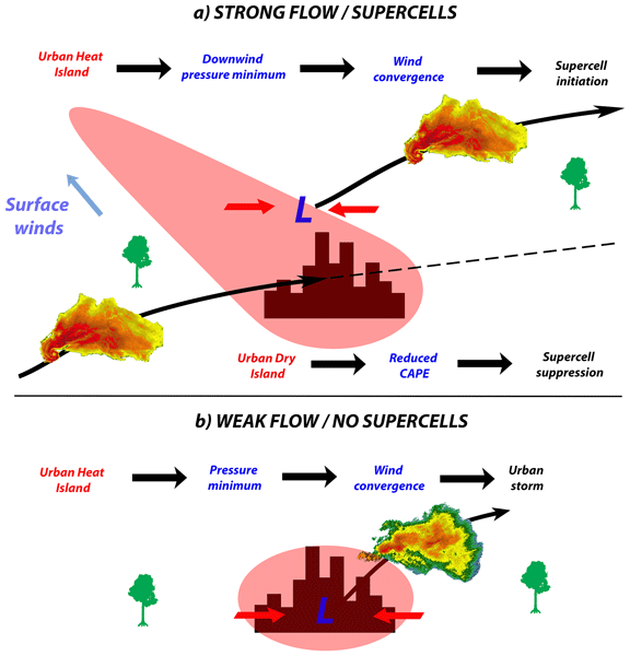
Most convective storm losses occur in urban areas, raising the question of whether cities can intensify severe storms, such as supercells. We found that cities can weaken an approaching supercell by reducing low-level moisture, but can also trigger a new one downwind. More urban vegetation reduces city effects on storm evolution, while building height has little impact. This conceptual model improves understanding of supercell–city interactions and supports advances in early warning systems.
Alireza Saeedi, Maria Martinez Mendoza, Eric Scott Krayenhoff, James Voogt, Andrea Zonato, Sylvie Leroyer, and Claudia Wagner-Riddle
EGUsphere, https://doi.org/10.5194/egusphere-2026-984, https://doi.org/10.5194/egusphere-2026-984, 2026
Short summary
Short summary
Green roofs can help cool cities, but models must represent how heat and water move through soil and plants correctly. We improved the green roof part of the WRF multi-layer weather model by adding more realistic descriptions of evaporation, heat storage, and plant water uptake. When tested against real measurements from a roof in London, Ontario, Canada, the updated model more accurately matched observed ground heat and latent heat fluxes.
Gianluca Pappaccogli, Andrea Zonato, Alberto Martilli, Riccardo Buccolieri, and Piero Lionello
Geosci. Model Dev., 18, 7129–7145, https://doi.org/10.5194/gmd-18-7129-2025, https://doi.org/10.5194/gmd-18-7129-2025, 2025
Short summary
Short summary
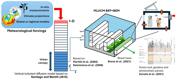
We present a multilayer urban model, named MLUCM BEP+BEM, able to represent detailed urban geometry and vegetation, while simulating their interactions and feedback with the atmosphere. Its accuracy and low computational cost make it ideal for offline climate projections assessing urban impacts under various emission scenarios. Its features enable analysis of urban overheating, energy demand, thermal comfort, and evaluation of strategies like green/cool roofs and photovoltaic panels.
Alfonso Ferrone, Étienne Vignon, Andrea Zonato, and Alexis Berne
The Cryosphere, 17, 4937–4956, https://doi.org/10.5194/tc-17-4937-2023, https://doi.org/10.5194/tc-17-4937-2023, 2023
Short summary
Short summary
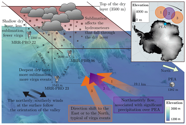
In austral summer 2019/2020, three K-band Doppler profilers were deployed across the Sør Rondane Mountains, south of the Belgian base Princess Elisabeth Antarctica. Their measurements, along with atmospheric simulations and reanalyses, have been used to study the spatial variability in precipitation over the region, as well as investigate the interaction between the complex terrain and the typical flow associated with precipitating systems.
Francesco De Martin, Christopher Rozoff, Andrea Zonato, Stefano Alessandrini, and Silvana Di Sabatino
Weather Clim. Dynam., 7, 2015–2042, https://doi.org/10.5194/wcd-7-2015-2026, https://doi.org/10.5194/wcd-7-2015-2026, 2026
Short summary
Short summary
Most convective storm losses occur in urban areas, raising the question of whether cities can intensify severe storms, such as supercells. We found that cities can weaken an approaching supercell by reducing low-level moisture, but can also trigger a new one downwind. More urban vegetation reduces city effects on storm evolution, while building height has little impact. This conceptual model improves understanding of supercell–city interactions and supports advances in early warning systems.
Harsh G. Kamath, Gordon B. Bonan, Zong-Liang Yang, Ronnie Abolafia-Rosenzweig, Cenlin He, Ashley Matheny, and Dev Niyogi
EGUsphere, https://doi.org/10.5194/egusphere-2026-4875, https://doi.org/10.5194/egusphere-2026-4875, 2026
This preprint is open for discussion and under review for Geoscientific Model Development (GMD).
Short summary
Short summary
Noah-MP-ML² v1.0 extends the community Noah-MP land surface model with a multilayer canopy, improved radiation and turbulence schemes, Medlyn stomatal conductance, and a mass-conserving Richards-equation solver. Evaluation at five forest FLUXNET sites shows improved simulation of friction velocity, turbulent heat fluxes, and vertical soil-moisture dynamics while identifying remaining uncertainties in soil hydraulic properties, rooting profiles, and plant hydraulics.
Alireza Saeedi, Maria Martinez Mendoza, Eric Scott Krayenhoff, James Voogt, Andrea Zonato, Sylvie Leroyer, and Claudia Wagner-Riddle
EGUsphere, https://doi.org/10.5194/egusphere-2026-984, https://doi.org/10.5194/egusphere-2026-984, 2026
Short summary
Short summary
Green roofs can help cool cities, but models must represent how heat and water move through soil and plants correctly. We improved the green roof part of the WRF multi-layer weather model by adding more realistic descriptions of evaporation, heat storage, and plant water uptake. When tested against real measurements from a roof in London, Ontario, Canada, the updated model more accurately matched observed ground heat and latent heat fluxes.
Gianluca Pappaccogli, Andrea Zonato, Alberto Martilli, Riccardo Buccolieri, and Piero Lionello
Geosci. Model Dev., 18, 7129–7145, https://doi.org/10.5194/gmd-18-7129-2025, https://doi.org/10.5194/gmd-18-7129-2025, 2025
Short summary
Short summary
We present a multilayer urban model, named MLUCM BEP+BEM, able to represent detailed urban geometry and vegetation, while simulating their interactions and feedback with the atmosphere. Its accuracy and low computational cost make it ideal for offline climate projections assessing urban impacts under various emission scenarios. Its features enable analysis of urban overheating, energy demand, thermal comfort, and evaluation of strategies like green/cool roofs and photovoltaic panels.
Kazeem Abiodun Ishola, Gerald Mills, Ankur Prabhat Sati, Benjamin Obe, Matthias Demuzere, Deepak Upreti, Gourav Misra, Paul Lewis, Daire Walsh, Tim McCarthy, and Rowan Fealy
Hydrol. Earth Syst. Sci., 29, 2551–2582, https://doi.org/10.5194/hess-29-2551-2025, https://doi.org/10.5194/hess-29-2551-2025, 2025
Short summary
Short summary
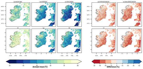
Global soil information introduces uncertainty into models that simulate soil hydrothermal changes. Using the Noah with Multiparameterization (Noah-MP) model with two different global soil datasets, we find under-represented soil properties in wet loam, causing a dry bias in soil moisture. This bias is more pronounced and drought categories are more severe in the SoilGrids dataset. We conclude that models should incorporate detailed, region-specific soil information to minimize model uncertainties.
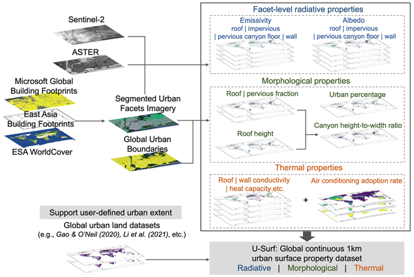
Yifan Cheng, Lei Zhao, TC Chakraborty, Keith Oleson, Matthias Demuzere, Xiaoping Liu, Yangzi Che, Weilin Liao, Yuyu Zhou, and Xinchang “Cathy” Li
Earth Syst. Sci. Data, 17, 2147–2174, https://doi.org/10.5194/essd-17-2147-2025, https://doi.org/10.5194/essd-17-2147-2025, 2025
Short summary
Short summary
The absence of globally consistent and spatially continuous urban surface input has long hindered large-scale high-resolution urban climate modeling. Using remote sensing, cloud computing, and machine learning, we developed U-Surf, a 1 km dataset providing key urban surface properties worldwide. U-Surf enhances urban representation across scales and supports kilometer-scale urban-resolving Earth system modeling unprecedentedly, with broader applications in urban studies and beyond.
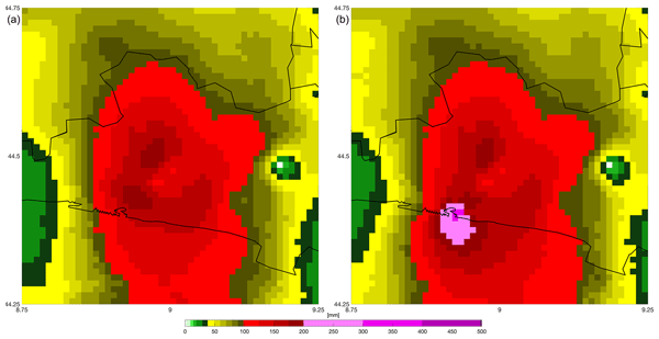
Nicola Loglisci, Giorgio Boni, Arianna Cauteruccio, Francesco Faccini, Massimo Milelli, Guido Paliaga, and Antonio Parodi
Nat. Hazards Earth Syst. Sci., 24, 2495–2510, https://doi.org/10.5194/nhess-24-2495-2024, https://doi.org/10.5194/nhess-24-2495-2024, 2024
Short summary
Short summary
We analyse the meteo-hydrological features of the 27 and 28 August 2023 event that occurred in Genoa. Rainfall observations were made using rain gauge networks based on either official networks or citizen science networks. The merged analysis stresses the spatial variability in the precipitation, which cannot be captured by the current spatial density of authoritative stations. Results show that at minimal distances the variations in cumulated rainfall over a sub-hourly duration are significant.
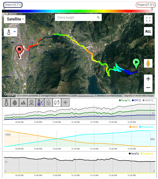
Francesco Barbano, Erika Brattich, Carlo Cintolesi, Abdul Ghafoor Nizamani, Silvana Di Sabatino, Massimo Milelli, Esther E. M. Peerlings, Sjoerd Polder, Gert-Jan Steeneveld, and Antonio Parodi
Atmos. Meas. Tech., 17, 3255–3278, https://doi.org/10.5194/amt-17-3255-2024, https://doi.org/10.5194/amt-17-3255-2024, 2024
Short summary
Short summary
The characterization of the urban microclimate starts with atmospheric monitoring using a dense array of sensors to capture the spatial variations induced by the different morphology, land cover, and presence of vegetation. To provide a new sensor for this scope, this paper evaluates the outdoor performance of a commercial mobile sensor. The results mark the sensor's ability to capture the same atmospheric variability as the reference, making it a valid solution for atmospheric monitoring.
Alfonso Ferrone, Étienne Vignon, Andrea Zonato, and Alexis Berne
The Cryosphere, 17, 4937–4956, https://doi.org/10.5194/tc-17-4937-2023, https://doi.org/10.5194/tc-17-4937-2023, 2023
Short summary
Short summary
In austral summer 2019/2020, three K-band Doppler profilers were deployed across the Sør Rondane Mountains, south of the Belgian base Princess Elisabeth Antarctica. Their measurements, along with atmospheric simulations and reanalyses, have been used to study the spatial variability in precipitation over the region, as well as investigate the interaction between the complex terrain and the typical flow associated with precipitating systems.
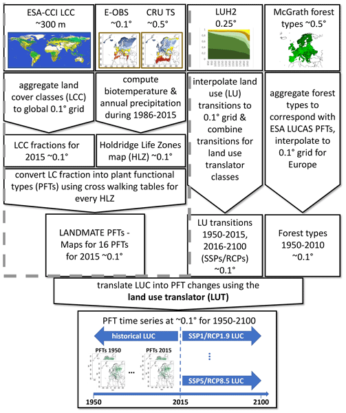
Peter Hoffmann, Vanessa Reinhart, Diana Rechid, Nathalie de Noblet-Ducoudré, Edouard L. Davin, Christina Asmus, Benjamin Bechtel, Jürgen Böhner, Eleni Katragkou, and Sebastiaan Luyssaert
Earth Syst. Sci. Data, 15, 3819–3852, https://doi.org/10.5194/essd-15-3819-2023, https://doi.org/10.5194/essd-15-3819-2023, 2023
Short summary
Short summary
This paper introduces the new high-resolution land use and land cover change dataset LUCAS LUC for Europe (version 1.1), tailored for use in regional climate models. Historical and projected future land use change information from the Land-Use Harmonization 2 (LUH2) dataset is translated into annual plant functional type changes from 1950 to 2015 and 2016 to 2100, respectively, by employing a newly developed land use translator.
Matthias Demuzere, Jonas Kittner, Alberto Martilli, Gerald Mills, Christian Moede, Iain D. Stewart, Jasper van Vliet, and Benjamin Bechtel
Earth Syst. Sci. Data, 14, 3835–3873, https://doi.org/10.5194/essd-14-3835-2022, https://doi.org/10.5194/essd-14-3835-2022, 2022
Short summary
Short summary
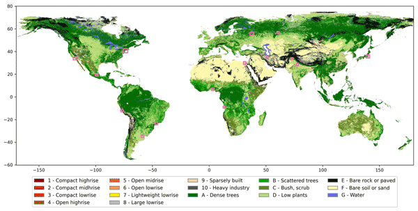
Because urban areas are key contributors to climate change but are also susceptible to multiple hazards, one needs spatially detailed information on urban landscapes to support environmental services. This global local climate zone map describes this much-needed intra-urban heterogeneity across the whole surface of the earth in a universal language and can serve as a basic infrastructure to study e.g. environmental hazards, energy demand, and climate adaptation and mitigation solutions.
Jorn Van de Velde, Matthias Demuzere, Bernard De Baets, and Niko E. C. Verhoest
Hydrol. Earth Syst. Sci., 26, 2319–2344, https://doi.org/10.5194/hess-26-2319-2022, https://doi.org/10.5194/hess-26-2319-2022, 2022
Short summary
Short summary
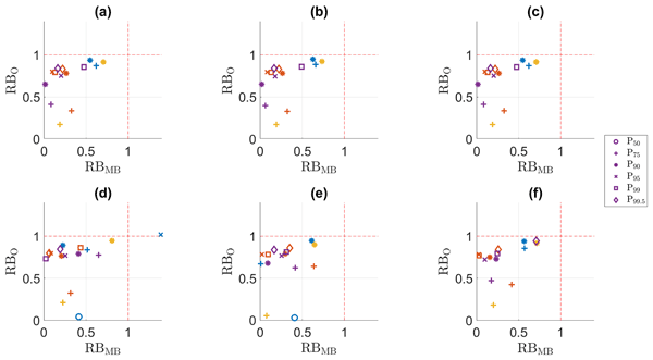
An important step in projecting future climate is the bias adjustment of the climatological and hydrological variables. In this paper, we illustrate how bias adjustment can be impaired by bias nonstationarity. Two univariate and four multivariate methods are compared, and for both types bias nonstationarity can be linked with less robust adjustment.
Vanessa Reinhart, Peter Hoffmann, Diana Rechid, Jürgen Böhner, and Benjamin Bechtel
Earth Syst. Sci. Data, 14, 1735–1794, https://doi.org/10.5194/essd-14-1735-2022, https://doi.org/10.5194/essd-14-1735-2022, 2022
Short summary
Short summary
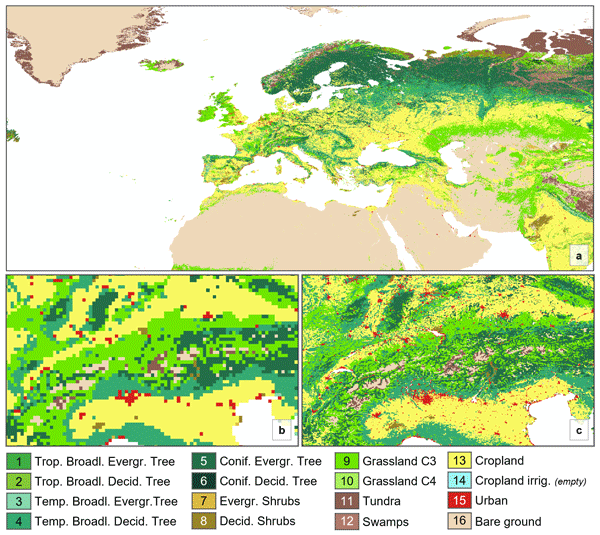
The LANDMATE plant functional type (PFT) land cover dataset for Europe 2015 (Version 1.0) is a gridded, high-resolution dataset for use in regional climate models. LANDMATE PFT is prepared using the expertise of regional climate modellers all over Europe and is easily adjustable to fit into different climate model families. We provide comprehensive spatial quality information for LANDMATE PFT, which can be used to reduce uncertainty in regional climate model simulations.
Cited articles
Adinolfi, M., Raffa, M., Reder, A., and Mercogliano, P.: Investigation on potential and limitations of ERA5 Reanalysis downscaled on Italy by a convection-permitting model, Clim. Dynam., 61, 4319–4342, https://doi.org/10.1007/s00382-023-06803-w, 2023. a
Aydin, Y., Janke, J., and Middleton, R.: A comparative review of microclimate and thermal comfort models: RayMan, ENVI-met, SOLWEIG, and STEVE, Sustain. Cities Soc., 46, 101–126, https://doi.org/10.1016/j.scs.2018.12.019, 2019. a
Bernard, J., Lindberg, F., and Oswald, S.: URock 2023a: an open-source GIS-based wind model for complex urban settings, Geosci. Model Dev., 16, 5703–5727, https://doi.org/10.5194/gmd-16-5703-2023, 2023. a, b, c, d
Bolton, D.: The computation of equivalent potential temperature, Mon. Weather Rev., 108, 1046–1053, https://doi.org/10.1175/1520-0493(1980)108<1046:TCOEPT>2.0.CO;2, 1980. a
Briegel, F., Wehrle, J., Schindler, D., and Christen, A.: High-resolution multi-scaling of outdoor human thermal comfort and its intra-urban variability based on machine learning, Geosci. Model Dev., 17, 1667–1688, https://doi.org/10.5194/gmd-17-1667-2024, 2024. a, b, c
Buo, I., Sagris, V., Jaagus, J., and Middel, A.: High-resolution thermal exposure and shade maps for cool corridor planning, Sustain. Cities Soc., 93, 104499, https://doi.org/10.1016/j.scs.2023.104499, 2023. a, b
Cheng, W.-C. and Porté-Agel, F.: Adjustment of Turbulent Boundary-Layer Flow to Idealized Urban Surfaces: A Large-Eddy Simulation Study, Bound.-Lay. Meteorol., 155, 249–270, https://doi.org/10.1007/s10546-015-0004-1, 2015. a
Cheng, Y., Niu, J., and Gao, N.: Thermal comfort models: A review and numerical investigation, Build. Environ., 47, 13–22, https://doi.org/10.1016/j.buildenv.2011.05.011, 2012. a
Chu, R. and Wang, K.: CFD in Urban Wind Resource Assessments: A Review, Energies, 18, https://doi.org/10.3390/en18102626, 2025. a, b
Cionco, R. M.: A wind-profile index for canopy flow, Bound.-Lay. Meteorol., 3, 255–263, https://doi.org/10.1007/BF02033923, 1972. a
Emmanuel, R. and Fernando, H. J. S.: Urban heat islands in humid and arid climates: role of urban form and thermal properties in Colombo, Sri Lanka and Phoenix, USA, Clim. Res., 34, 241–251, https://doi.org/10.3354/cr00694, 2007. a
Fiala, D., Havenith, G., Bröde, P., Kampmann, B., and Jendritzky, G.: UTCI-Fiala multi-node model of human heat transfer and temperature regulation, Int. J. Biometeorol., 56, 429–441, https://doi.org/10.1007/s00484-011-0424-7, 2012. a
Gorelick, N., Hancher, M., Dixon, M., Ilyushchenko, S., Thau, D., and Moore, R.: Google Earth Engine: Planetary-scale geospatial analysis, Remote Sens. Environ., 202, 18–27, https://doi.org/10.1016/j.rse.2017.06.031, 2017. a, b, c
Grandoni, L., Michard, M., Grosjean, N., and Salizzoni, P.: The dynamics of a wake behind an isolated model tree within an atmospheric boundary layer, Bounda.-Lay. Meteorol., 192, 26, https://doi.org/10.1007/s10546-026-00971-y, 2026. a
Haeffelin, M., Ribaud, J.-F., Céspedes, J., Dupont, J.-C., Lemonsu, A., Masson, V., Nagel, T., and Kotthaus, S.: Impact of boundary layer stability on urban park cooling effect intensity, Atmos. Chem. Phys., 24, 14101–14122, https://doi.org/10.5194/acp-24-14101-2024, 2024. a
Hersbach, H., Bell, B., Berrisford, P., Hirahara, S., Horányi, A., Muñoz-Sabater, J., Nicolas, J., Peubey, C., Radu, R., Schepers, D., Simmons, A., Soci, C., Abdalla, S., Abellan, X., Balsamo, G., Bechtold, P., Biavati, G., Bidlot, J., Bonavita, M., De Chiara, G., Dahlgren, P., Dee, D., Diamantakis, M., Dragani, R., Flemming, J., Forbes, R., Fuentes, M., Geer, A., Haimberger, L., Healy, S. B., Hogan, R. J., Hólm, E., Janisková, M., Keeley, S., Laloyaux, P., Lopez, P., Lupu, C., Radnóti, G., de Rosnay, P., Rozum, I., Vamborg, F., Villaume, S., and Thépaut, J.-N.: The ERA5 global reanalysis, Q. J. Roy. Meteor. Soc., 146, 1999–2049, https://doi.org/10.1002/qj.3803, 2020. a, b, c
Höppe, P.: The physiological equivalent temperature – a universal index for the biometeorological assessment of the thermal environment, Int. J. Biometeorol., 43, 71–75, https://doi.org/10.1007/s004840050118, 1999. a, b
Hüser, C., Wolf, L., Gottschalk, N., Kittner, J., Kraas, B., Mittelstädt, C., Reinhart, V., Sismanidis, P., Wawrzyniak, N., and Bechtel, B.: Data2Resilience – A Biometeorological Weather Station Network in Dortmund: Station Documentation, Zenodo [data set], https://doi.org/10.5281/zenodo.18221203, 2026. a, b
Jänicke, B., Meier, F., Lindberg, F., Schubert, S., and Scherer, D.: Towards city-wide, building-resolving analysis of mean radiant temperature, Urban Climate, 15, 83–98, https://doi.org/10.1016/j.uclim.2015.11.003, 2016. a, b
Jendritzky, G., de Dear, R., and Havenith, G.: UTCI – Why another thermal index?, Int. J. Biometeorol., 56, 421–428, https://doi.org/10.1007/s00484-011-0513-7, 2012. a, b
Kamath, H. G., Sudharsan, N., Singh, M., Wallenberg, N., Lindberg, F., and Niyogi, D.: SOLWEIG-GPU: GPU-Accelerated Thermal Comfort Modeling Framework for Urban Digital Twins, Journal of Open Source Software, 11, 9535, https://doi.org/10.21105/joss.09535, 2026. a, b
Kaplan, H. and Dinar, N.: A Lagrangian dispersion model for calculating concentration distribution within a built-up domain, Atmos. Environ., 30, 4197–4207, https://doi.org/10.1016/1352-2310(96)00144-6, 1996. a
Kittner, J., Fenner, D., Demuzere, M., and Bechtel, B.: Analysis of nocturnal urban heat advection using crowd weather stations, Q. J. Roy. Meteor. Soc., 151, e5065, https://doi.org/10.1002/qj.5065, 2025. a
Konarska, J., Lindberg, F., Larsson, A., Thorsson, S., and Holmer, B.: Transmissivity of solar radiation through crowns of single urban trees – application for outdoor thermal comfort modelling, Theor. Appl. Climatol., 117, 363–376, https://doi.org/10.1007/s00704-013-1000-3, 2014. a
Kusaka, H., Ikeda, R., Sato, T., Iizuka, S., and Boku, T.: Development of a Multi-Scale Meteorological Large-Eddy Simulation Model for Urban Thermal Environmental Studies: The “City-LES” Model Version 2.0, J. Adv. Model. Earth Sy., 16, e2024MS004367, https://doi.org/10.1029/2024MS004367, 2024. a
Lang, N., Jetz, W., Schindler, K., and Wegner, J. D.: A high-resolution canopy height model of the Earth, Nat. Ecol. Evol., 7, 1778–1789, https://doi.org/10.1038/s41559-023-02206-6, 2023. a, b
Li, X. and Wang, G.: GPU parallel computing for mapping urban outdoor heat exposure, Theor. Appl. Climatol., https://doi.org/10.1007/s00704-021-03692-z, 2021. a
Li, X., Wang, G., Zaitchik, B., Hsu, A., and Chakraborty, T. C.: Sensitivity and vulnerability to summer heat extremes in major cities of the United States, Environ. Res. Lett., 19, 094039, https://doi.org/10.1088/1748-9326/ad6c64, 2024. a
Lindberg, F. and Grimmond, C. S. B.: The influence of vegetation and building morphology on shadow patterns and mean radiant temperatures in urban areas: model development and evaluation, Theor. Appl. Climatol., 105, 311–323, https://doi.org/10.1007/s00704-010-0382-8, 2011a. a, b, c
Lindberg, F. and Grimmond, C. S. B.: Nature of vegetation and building morphology characteristics across a city: Influence on shadow patterns and mean radiant temperatures in London, Urban Ecosyst., 14, 617–634, https://doi.org/10.1007/s11252-011-0184-5, 2011b. a, b, c
Lindberg, F., Holmer, B., and Thorsson, S.: SOLWEIG 1.0 – Modelling spatial variations of 3D radiant fluxes and mean radiant temperature in complex urban settings, Int. J. Biometeorol., 52, 697–713, https://doi.org/10.1007/s00484-008-0162-7, 2008. a, b
Lindberg, F., Onomura, S., and Grimmond, C. S. B.: Influence of ground surface characteristics on the mean radiant temperature in urban areas, Int. J. Biometeorol., 60, 1439–1452, https://doi.org/10.1007/s00484-016-1135-x, 2016. a
Lindberg, F., Grimmond, C. S. B., Gabey, A., Huang, B., Kent, C. W., Sun, T., Theeuwes, N. E., Järvi, L., Ward, H. C., Capel-Timms, I., Chang, Y., Jonsson, P., Krave, N., Liu, D., Meyer, D., Olofson, K. F. G., Tan, J., Wästberg, D., Xue, L., and Zhang, Z.: Urban Multi-scale Environmental Predictor (UMEP): An integrated tool for city-based climate services, Environ. Modell. Softw., 99, 70–87, https://doi.org/10.1016/j.envsoft.2017.09.020, 2018. a, b
Lindberg, F., Wallenberg, N., Thorsson, S., Haeger-Eugensson, M., Lönn, J., Holmberg, B., Frid, M., and Fahlström, J.: Micro-scale, city-wide analysis of outdoor thermal comfort during heatwaves in high latitude cities: influence of building geometry and vegetation, Int. J. Biometeorol., https://doi.org/10.1007/s00484-025-03030-2, 2025. a
Liu, Y., Luo, Z., and Grimmond, S.: Impact of building envelope design parameters on diurnal building anthropogenic heat emission, Build. Environ., 234, 110134, https://doi.org/10.1016/j.buildenv.2023.110134, 2023. a
Margairaz, F., Eshagh, H., Nemati Hayati, A., Pardyjak, E. R., and Stoll, R.: Development and Evaluation of an Isolated-Tree Flow Model for Neutral-Stability Conditions, Urban Climate, 42, 101083, https://doi.org/10.1016/j.uclim.2022.101083, 2022. a, b
Maronga, B., Banzhaf, S., Burmeister, C., Esch, T., Forkel, R., Fröhlich, D., Fuka, V., Gehrke, K. F., Geletič, J., Giersch, S., Gronemeier, T., Groß, G., Heldens, W., Hellsten, A., Hoffmann, F., Inagaki, A., Kadasch, E., Kanani-Sühring, F., Ketelsen, K., Khan, B. A., Knigge, C., Knoop, H., Krč, P., Kurppa, M., Maamari, H., Matzarakis, A., Mauder, M., Pallasch, M., Pavlik, D., Pfafferott, J., Resler, J., Rissmann, S., Russo, E., Salim, M., Schrempf, M., Schwenkel, J., Seckmeyer, G., Schubert, S., Sühring, M., von Tils, R., Vollmer, L., Ward, S., Witha, B., Wurps, H., Zeidler, J., and Raasch, S.: Overview of the PALM model system 6.0, Geosci. Model Dev., 13, 1335–1372, https://doi.org/10.5194/gmd-13-1335-2020, 2020. a
Mayer, H. and Höppe, P.: Thermal comfort of man in different urban environments, Theor. Appl. Climatol., 38, 43–49, https://doi.org/10.1007/BF00866252, 1987. a
Mayer, H., Holst, J., Dostal, P., Imbery, F., and Schindler, D.: Human thermal comfort in summer within an urban street canyon in Central Europe, Meteorol. Z., 17, 241–250, https://doi.org/10.1127/0941-2948/2008/0285, 2008. a
Middel, A. and Krayenhoff, E. S.: Micrometeorological determinants of pedestrian thermal exposure during record-breaking heat in Tempe, Arizona: Introducing the MaRTy observational platform, Sci. Total Environ., 659, 129–143, https://doi.org/10.1016/j.scitotenv.2018.12.166, 2019. a
Oke, T. R., Mills, G., Christen, A., and Voogt, J. A.: Urban Climates, Cambridge University Press, https://doi.org/10.1017/9781139016476, 2017. a
Oostwegel, L. J. N., Schorlemmer, D., and Guéguen, P.: From Footprints to Functions: A Comprehensive Global and Semantic Building Footprint Dataset, Sci. Data, 12, 1699, https://doi.org/10.1038/s41597-025-06132-z, 2025. a, b
Perez, R., Seals, R., and Michalsky, J.: All-weather model for sky luminance distribution: preliminary configuration and validation, Sol. Energy, 50, 235–245, https://doi.org/10.1016/0038-092X(93)90017-I, 1993. a
Plein, M., Kersten, F., Zeeman, M., and Christen, A.: Street-Level Weather Station Network in Freiburg, Germany: Station Documentation, Tech. rep., Zenodo, https://doi.org/10.5281/zenodo.12732551, 2024. a
Potapov, P., Li, X., Hernandez-Serna, A., Tyukavina, A., Hansen, M. C., Kommareddy, A., Pickens, A., Turubanova, S., Tang, H., Silva, C. E., Armston, J., Dubayah, R., Blair, J. B., and Hofton, M.: Mapping global forest canopy height through integration of GEDI and Landsat data, Remote Sens. Environ., 253, 112165, https://doi.org/10.1016/j.rse.2020.112165, 2021. a, b
Reindl, D. T., Beckman, W. A., and Duffie, J. A.: Diffuse fraction correlations, Sol. Energy, 45, 1–7, https://doi.org/10.1016/0038-092X(90)90060-P, 1990. a
Robinson, D., Brambilla, S., Brown, M. J., Conry, P., Quaife, B., and Linn, R. R.: QUIC-URB and QUIC-Fire extension to complex terrain: Development of a terrain-following coordinate system, Environ. Modell. Softw., 159, 105579, https://doi.org/10.1016/j.envsoft.2022.105579, 2023. a
Romps, D. M.: Exact expression for the lifting condensation level, J. Atmos. Sci., 74, 3891–3900, https://doi.org/10.1175/JAS-D-17-0102.1, 2017. a
Rothfusz, L. P.: The heat index equation (or, more than you ever wanted to know about heat index), Fort Worth, Texas: National Oceanic and Atmospheric Administration, National Weather Service, Office of Meteorology, 9023, 640, https://www.weather.gov/media/ffc/ta_htindx.PDF (last access: 29 July 2026), 1990. a
Santiago, J. L. and Martilli, A.: A Dynamic Urban Canopy Parameterization for Mesoscale Models Based on Computational Fluid Dynamics Reynolds-Averaged Navier–Stokes Microscale Simulations, Bound.-Lay. Meteorol., 137, 417–439, https://doi.org/10.1007/s10546-010-9538-4, 2010. a
Simon, H.: Modeling urban microclimate: development, implementation and evaluation of new and improved calculation methods for the urban microclimate model ENVI-met, PhD thesis, Johannes Gutenberg-Universität Mainz, Mainz, https://doi.org/10.25358/openscience-4042, 2016. a
Steadman, R. G.: The assessment of sultriness. Part I: A temperature-humidity index based on human physiology and clothing science, J. Appl. Meteorol. Clim., 18, 861–873, 1979. a
Theeuwes, N. E., Steeneveld, G.-J., Ronda, R. J., and Holtslag, A. A. M.: A diagnostic equation for the daily maximum urban heat island effect for cities in northwestern Europe, Int. J. Climatol., 37, 443–454, https://doi.org/10.1002/joc.4717, 2016. a, b, c
Thorsson, S., Lindqvist, M., and Lindberg, F.: Different methods for estimating the mean radiant temperature in an outdoor urban setting, Int. J. Climatol., 27, 1983–1993, https://doi.org/10.1002/joc.1537, 2007. a, b
Thorsson, S., Lindberg, F., Björklund, J., Holmer, B., and Rayner, D.: Potential changes in outdoor thermal comfort conditions in Gothenburg, Sweden due to climate change: the influence of urban geometry, Int. J. Climatol., 31, 324–335, https://doi.org/10.1002/joc.2231, 2011. a
Tolan, J., Yang, H.-I., Nosarzewski, B., Couairon, G., Vo, H. V., Brandt, J., Spore, J., Majumdar, S., Haziza, D., Vamaraju, J., Moutakanni, T., Bojanowski, P., Johns, T., White, B., Tiecke, T., and Couprie, C.: Very high resolution canopy height maps from RGB imagery using self-supervised vision transformer and convolutional decoder trained on aerial lidar, Remote Sens. Environ., 300, 113888, https://doi.org/10.1016/j.rse.2023.113888, 2024. a, b
Toparlar, Y., Blocken, B., Maiheu, B., and van Heijst, G.: A review on the CFD analysis of urban microclimate, Renew. Sust. Energ. Rev., 80, 1613–1640, https://doi.org/10.1016/j.rser.2017.05.248, 2017. a
Wallenberg, N., Lindberg, F., Holmer, B., and Thorsson, S.: The influence of anisotropic diffuse shortwave radiation on mean radiant temperature in outdoor urban environments, Urban Climate, 31, 100589, https://doi.org/10.1016/j.uclim.2020.100589, 2020. a, b, c
Wallenberg, N., Lindberg, F., Holmer, B., and Rayner, D.: An anisotropic parametrization scheme for longwave irradiance and its impact on radiant load in urban outdoor settings, Int. J. Biometeorol., https://doi.org/10.1007/s00484-023-02441-3, 2023. a, b, c
Wallenberg, N., Holmer, B., Lindberg, F., Lönn, J., Maesel, E., and Rayner, D.: A simple step heating approach for wall surface temperature estimation in the SOlar and LongWave Environmental Irradiance Geometry (SOLWEIG) model, Geosci. Model Dev., 19, 1321–1336, https://doi.org/10.5194/gmd-19-1321-2026, 2026. a
Yamazaki, D., Ikeshima, D., Tawatari, R., Yamaguchi, T., O'Loughlin, F., Neal, J. C., Sampson, C. C., Kanae, S., and Bates, P. D.: A high-accuracy map of global terrain elevations, Geophys. Res. Lett., 44, 5844–5853, https://doi.org/10.1002/2017GL072874, 2017. a, b, c
Yang, M., Oh, G., Xu, T., Kim, J., Kang, J.-H., and Choi, J.-I.: Multi-GPU-based real-time large-eddy simulations for urban microclimate, Build. Environ., 245, 110856, https://doi.org/10.1016/j.buildenv.2023.110856, 2023. a
Zanaga, D., Van De Kerchove, R., Daems, D., De Keersmaecker, W., Brockmann, C., Kirches, G., Wevers, J., Cartus, O., Santoro, M., Fritz, S., Lesiv, M., Herold, M., Tsendbazar, N.-E., Xu, P., Ramoino, F., and Arino, O.: ESA WorldCover 10 m 2021 v200, version v200, Zenodo, https://doi.org/10.5281/zenodo.7254221, 2022. a, b, c
Zhu, X. X., Chen, S., Zhang, F., Shi, Y., and Wang, Y.: GlobalBuildingAtlas: an open global and complete dataset of building polygons, heights and LoD1 3D models, Earth Syst. Sci. Data, 17, 6647–6668, https://doi.org/10.5194/essd-17-6647-2025, 2025. a, b, c, d
Zonato, A., Martilli, A., Di Sabatino, S., Zardi, D., and Giovannini, L.: Evaluating the performance of a novel WUDAPT averaging technique to define urban morphology with mesoscale models, Urban Climate, 31, 100584, https://doi.org/10.1016/j.uclim.2020.100584, 2020. a
Zonato, A., Martilli, A., Santiago, J. L., Zardi, D., and Giovannini, L.: On a new one-dimensional k−ε turbulence closure for building-induced drag, Q. J. Roy. Meteorol. Soc., 149, 1674–1689, https://doi.org/10.1002/qj.4476, 2023. a
Zonato, A., Kamath, H. G., Sudharsan, N., Monaco, L., Kittner, J., Wolf, L., Demuzere, M., Middel, A., Bechtel, B., and Milelli, M.: GLIDE-SOL: A GPU-accelerated Global Lightweight Infrastructure for Diagnostic Environmental Modeling with SOLWEIG, version v1, Zenodo [code], https://doi.org/10.5281/zenodo.18671813, 2026. a
Short summary
Cities need fast, reliable heat-stress maps to plan cooling measures and protect people. We built an automated workflow that gathers global public data, runs an outdoor comfort model much faster on graphics processing units, and adds simple corrections for wind and night-time warming. Tested in Dortmund against many sensors, errors fell from about ten to under three °C.
Cities need fast, reliable heat-stress maps to plan cooling measures and protect people. We...


