
Articles | Volume 19, issue 13
https://doi.org/10.5194/gmd-19-5979-2026
© Author(s) 2026. This work is distributed under
the Creative Commons Attribution 4.0 License.
the Creative Commons Attribution 4.0 License.
https://doi.org/10.5194/gmd-19-5979-2026
© Author(s) 2026. This work is distributed under
the Creative Commons Attribution 4.0 License.
the Creative Commons Attribution 4.0 License.
Development and technical paper
| 
13 Jul 2026
Development and technical paper |
| 13 Jul 2026
| 13 Jul 2026
HyperGas 1.0: a python package for analyzing hyperspectral data for greenhouse gases from retrieval to emission rate quantification

SRON Space Research Organisation Netherlands, 2333 CA, Leiden, the Netherlands
Joannes D. Maasakkers
SRON Space Research Organisation Netherlands, 2333 CA, Leiden, the Netherlands
Tobias A. de Jong
SRON Space Research Organisation Netherlands, 2333 CA, Leiden, the Netherlands
Paul Tol
SRON Space Research Organisation Netherlands, 2333 CA, Leiden, the Netherlands
Frances Reuland
Department of Energy Science & Engineering, Stanford University, Stanford, California, 94305, United States
Adam R. Brandt
Department of Energy Science & Engineering, Stanford University, Stanford, California, 94305, United States
Eric A. Kort
Department of Climate & Space Sciences & Engineering, University of Michigan, Ann Arbor, MI 48109, USA
Taylor J. Adams
Department of Climate & Space Sciences & Engineering, University of Michigan, Ann Arbor, MI 48109, USA
Ilse Aben
SRON Space Research Organisation Netherlands, 2333 CA, Leiden, the Netherlands
Department of Earth Sciences, Vrije Universiteit Amsterdam, Amsterdam, 1081 HV, the Netherlands
Related authors
Srijana Lama, Joannes D. Maasakkers, Xin Zhang, Marianne Girard, Swarna Dutt, Suyash Nandgaonkar, Daniel J. Varon, Melissa P. Sulprizio, Lucas A. Estrada, Nicholas Balasus, Robert J. Parker, Yukio Terao, and Ilse Aben
EGUsphere, https://doi.org/10.5194/egusphere-2025-6528, https://doi.org/10.5194/egusphere-2025-6528, 2026
Short summary
Short summary
Methane is the second most important anthropogenic greenhouse gas in terms of radiative forcing, with a global warming potential 27–30 times that of CO2 over a 100-year timescale. Effective mitigation requires a detailed understanding of the spatial distribution and magnitude of emissions. Here, we quantify India’s 2021 methane emissions at a resolution of up to 0.25° × 0.3125° using TROPOMI observations within the Bayesian Integrated Methane Inversion framework.
Xiumei Zhang, Ronald van der A, Jieying Ding, Xin Zhang, and Yan Yin
Atmos. Chem. Phys., 23, 5587–5604, https://doi.org/10.5194/acp-23-5587-2023, https://doi.org/10.5194/acp-23-5587-2023, 2023
Short summary
Short summary
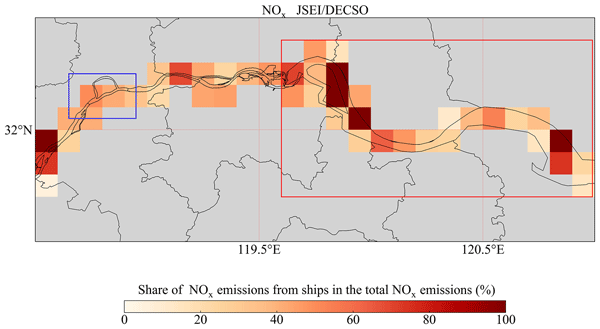
We compiled a ship emission inventory based on automatic identification system (AIS) signals in the Jiangsu section of the Yangtze River. This ship emission inventory was compared with Chinese bottom-up inventories and the satellite-derived emissions from TROPOMI. The result shows a consistent spatial distribution, with riverine cities having high NOx emissions. Inland ship emissions of NOx are shown to contribute at least 40 % to air pollution along the river.
Xin Zhang, Yan Yin, Ronald van der A, Henk Eskes, Jos van Geffen, Yunyao Li, Xiang Kuang, Jeff L. Lapierre, Kui Chen, Zhongxiu Zhen, Jianlin Hu, Chuan He, Jinghua Chen, Rulin Shi, Jun Zhang, Xingrong Ye, and Hao Chen
Atmos. Chem. Phys., 22, 5925–5942, https://doi.org/10.5194/acp-22-5925-2022, https://doi.org/10.5194/acp-22-5925-2022, 2022
Short summary
Short summary
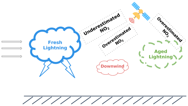
The importance of convection to the ozone and nitrogen oxides (NOx) produced from lightning has long been an open question. We utilize the high-resolution chemistry model with ozonesondes and space observations to discuss the effects of convection over southeastern China, where few studies have been conducted. Our results show the transport and chemistry contributions for various storms and demonstrate the ability of TROPOMI to estimate the lightning NOx production over small-scale convection.
Daniel Cusworth, Daniel Varon, Dylan Jervis, Jason McKeever, Alexander Turner, Christian Frankenberg, John Worden, Andrew Thorpe, Jay Fahlen, Sudhanshu Pandey, Joannes Maasakkers, Ilse Aben, Annmarie Eldering, Riley Duren, Bradley Conrad, Tia Scarpelli, Daniel Bon, Mackenzie Huffman, Itziar Irakulis-Loitxate, Luis Guanter, Jason Schroeder, Benjamin Hmiel, Evan Sherwin, Sean Crowell, Eric Kort, Adam Brandt, Frances Reuland, Maryann Sargent, James East, and Daniel Jacob
EGUsphere, https://doi.org/10.5194/egusphere-2026-6060, https://doi.org/10.5194/egusphere-2026-6060, 2026
This preprint is open for discussion and under review for Atmospheric Chemistry and Physics (ACP).
Short summary
Short summary
In this review, we summarize the current and anticipated state of satellite remote sensing for point sources. In particular, we are provide and update to the fleet of point source imaging satellites, summarize the nuance around data availability and revisit, detail data processing pipelines and validation procedures, describe how to benchmark detection performance, and finally, describe demonstrated use-cases for satellite point source observations.
Clara M. Nussbaumer, Colette L. Heald, Teresa Campos, Eric A. Kort, Paul B. Krummel, Ray L. Langenfelds, Monica Madronich, Kathryn McKain, Gabrielle Pétron, Ann Stavert, and Steven C. Wofsy
EGUsphere, https://doi.org/10.5194/egusphere-2026-5476, https://doi.org/10.5194/egusphere-2026-5476, 2026
This preprint is open for discussion and under review for Atmospheric Chemistry and Physics (ACP).
Short summary
Short summary
Changes in emissions and climate increasingly impact the remote Southern Hemisphere and we know little about the consequences for the atmospheric composition. We investigate if rapid increases in the greenhouse gas methane since 2008 have led to increases in carbon monoxide. A global model confirms this hypothesis and shows that enhanced emissions from plants and rising temperatures also contribute to the trend. Observations are inconsistent and highlight the need for more accurate measurements.
Clayton Roberts, Joannes D. Maasakkers, Tobias A. de Jong, Berend J. Schuit, Shubham Sharma, Theo Huegens, Anne-Wil van den Berg, Sander Houweling, and Ilse Aben
Atmos. Meas. Tech., 19, 5659–5682, https://doi.org/10.5194/amt-19-5659-2026, https://doi.org/10.5194/amt-19-5659-2026, 2026
Short summary
Short summary
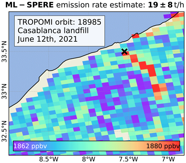
Methane is a powerful greenhouse gas, and cutting its emissions can slow climate change in the near term. We have created ML-SPERE, a new machine-learning based method that uses TROPOMI observations and weather data to better estimate emission rates for large methane plumes. It has proved more accurate than the Integrated Mass Enhancement (IME) method when tested on simulated satellite observations. When applied to real TROPOMI plumes, ML-SPERE produces estimates that agree with other methods.
Daniel A. Potts, Harjinder Sembhi, Matthieu Dogniaux, Joannes D. Maasakkers, Berend J. Schuit, Dirk Schuettemeyer, Timon Hummel, Rocio Barrio Guillo, Oliver Schneising, Luis Guanter, and Ilse Aben
EGUsphere, https://doi.org/10.5194/egusphere-2026-3797, https://doi.org/10.5194/egusphere-2026-3797, 2026
This preprint is open for discussion and under review for Atmospheric Chemistry and Physics (ACP).
Short summary
Short summary
Routine monitoring of industrial emissions is vital to understand the location, frequency, and intensity of methane emissions. We used satellite and aircraft measurements to understand methane emissions from Madrid across various scales and sectors. Using a range of methods, we identify a clear gap between top-down and bottom-up approaches, discuss challenges associated with satellite interpretation, connect emissions to on-site practices, and make recommendations towards operational use.
Ayesha Riaz, Kang Sun, Brian D. Baker, Brian Buma, Karen E. Cady-Pereira, Christopher Chan Miller, William C. Eddy III, Betsy M. Farris, Thomas U. Kampe, Eric A. Kort, Nathan P. Leisso, Robert Spurr, Emily R. Stuchiner, and Wendy H. Yang
Atmos. Meas. Tech., 19, 5169–5191, https://doi.org/10.5194/amt-19-5169-2026, https://doi.org/10.5194/amt-19-5169-2026, 2026
Short summary
Short summary
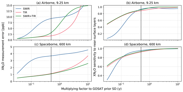
N2O is a powerful greenhouse gas mainly released from agricultural soils, but its emissions are difficult to track as they vary strongly in space and time. We tested whether combining two kind of infrared measurements in one instrument could improve ability of airborne and satellite instruments to observe these emissions. We found that this combined approach improves sensitivity to near-surface emissions with low measurement error and could guide the design of future N2O dedicated missions.
Aurélien Sicsik-Paré, Audrey Fortems-Cheiney, Isabelle Pison, Grégoire Broquet, Alvin Opler, Elise Potier, Adrien Martinez, Oliver Schneising, Michael Buchwitz, Joannes D. Maasakkers, Tobias Borsdorff, and Antoine Berchet
Atmos. Chem. Phys., 26, 10423–10454, https://doi.org/10.5194/acp-26-10423-2026, https://doi.org/10.5194/acp-26-10423-2026, 2026
Short summary
Short summary
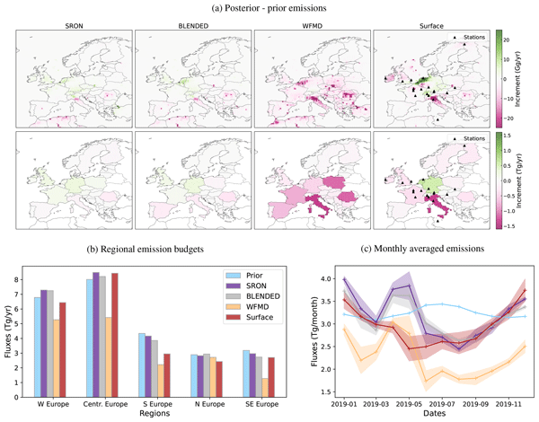
Assimilating satellite methane observations provides top-down quantification of regional methane emissions. This study compares European emissions in 2019 estimated from the inversion of three satellite datasets. We find inconsistencies in national budgets and spatial patterns, with no product clearly superior. We disentangle drivers of the differences in emissions, highlighting the impact of differences in coverage, observations and errors on the consistency of methane emission estimates.
Audrey McManemin, Catherine Juéry, Vincent Blandin, Matthew Baker, Stéphane Bauguitte, Dominik Brunner, Philippine Burdeau, James Lawrence France, Anders M. Fredenslund, Andreas Hueni, Gerrit Kuhlmann, Patryk Łakomiec, Sando Meier, Roberto Paglini, Roubina Papaconstantinou, Jean-Daniel Paris, Pierre-Yves Quehe, Thomas Röckmann, Charlotte Scheutz, Martina Schmidt, Marius Vögtli, Julia B. Wietzel, and Adam R. Brandt
EGUsphere, https://doi.org/10.5194/egusphere-2026-1744, https://doi.org/10.5194/egusphere-2026-1744, 2026
Short summary
Short summary
Researchers tested five university-led systems to measure methane leaks at a facility in France. By releasing known amounts of gas, researchers checked if mobile tools on vehicles and planes could accurately detect and quantify emissions. Most sensors were excellent at finding leaks, but their accuracy in measuring the exact emission rate varied. Weather, especially low wind, significantly impacted results. These findings help improve how we track greenhouse gases to meet climate goals.
John Worden, Sudhanshu Pandey, Hannah Nesser, Kevin Bowman, Colin Harkins, Congmeng Lyu, Joannes D. Maasakkers, Deborah Gordon, Daniel Jacob, Lucas Estrada, Daniel J. Varon, James D. East, Lauren Schmeisser, and Zhen Qu
Atmos. Chem. Phys., 26, 8855–8873, https://doi.org/10.5194/acp-26-8855-2026, https://doi.org/10.5194/acp-26-8855-2026, 2026
Short summary
Short summary
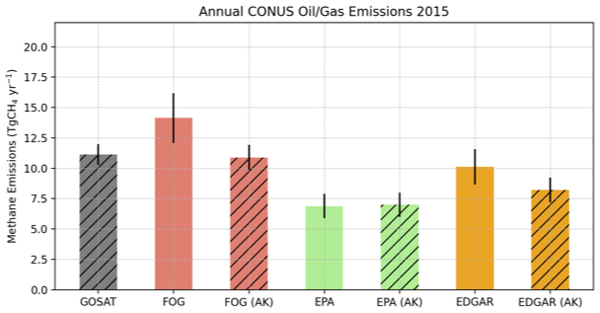
To support methane reduction, we compared three widely used maps of methane emissions in the United States with estimates derived from a methane-measuring satellite from 2012 to 2020. The satellite indicates higher emissions from oil and gas production and from livestock in several regions, while other sources were harder to pin down. Neither approach shows a clear change over time. The results point to where better measurements can most improve emissions reporting and guide mitigation.
Taylor J. Adams, Genevieve Plant, and Eric A. Kort
Atmos. Chem. Phys., 26, 5517–5529, https://doi.org/10.5194/acp-26-5517-2026, https://doi.org/10.5194/acp-26-5517-2026, 2026
Short summary
Short summary
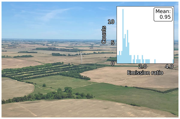
Nitrous oxide (N2O) is a potent greenhouse gas and ozone-depleting substance emitted from agriculture. Emissions cannot presently be observed from space. We leverage the co-emission of reactive nitrogen oxides (NO + NO2 = NOx) from croplands by determining N2O : NOx emissions ratios with aircraft. We apply these ratios to daily estimates of NOx emissions derived from space-based observations, thus generating a space-based proxy for N2O emissions, with close agreement against independent observations.
Srijana Lama, Joannes D. Maasakkers, Xin Zhang, Marianne Girard, Swarna Dutt, Suyash Nandgaonkar, Daniel J. Varon, Melissa P. Sulprizio, Lucas A. Estrada, Nicholas Balasus, Robert J. Parker, Yukio Terao, and Ilse Aben
EGUsphere, https://doi.org/10.5194/egusphere-2025-6528, https://doi.org/10.5194/egusphere-2025-6528, 2026
Short summary
Short summary
Methane is the second most important anthropogenic greenhouse gas in terms of radiative forcing, with a global warming potential 27–30 times that of CO2 over a 100-year timescale. Effective mitigation requires a detailed understanding of the spatial distribution and magnitude of emissions. Here, we quantify India’s 2021 methane emissions at a resolution of up to 0.25° × 0.3125° using TROPOMI observations within the Bayesian Integrated Methane Inversion framework.
Audrey McManemin, Catherine Juéry, Vincent Blandin, James L. France, Philippine Burdeau, and Adam R. Brandt
Atmos. Meas. Tech., 19, 923–934, https://doi.org/10.5194/amt-19-923-2026, https://doi.org/10.5194/amt-19-923-2026, 2026
Short summary
Short summary
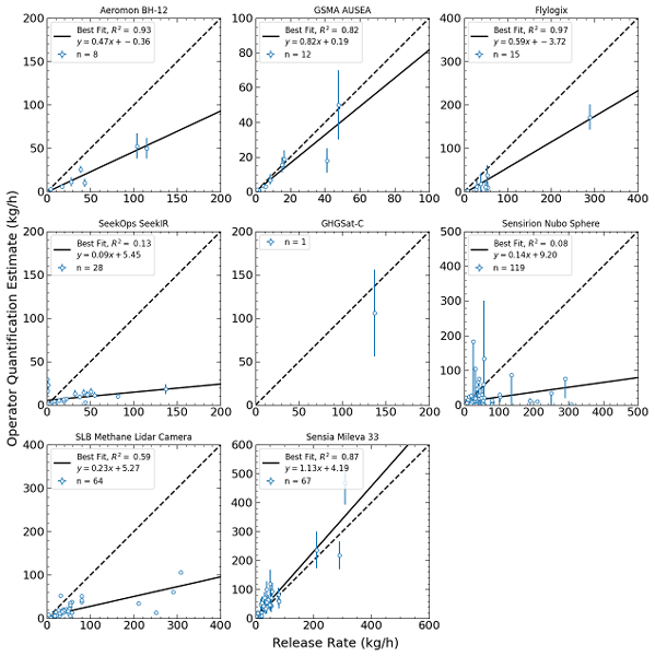
This experiment tested the ability of different technologies to detect and measure methane emissions. Participating teams used satellites, drones, and other systems to estimate methane leak rates without knowing the true rate. Some systems were more accurate than others, and wind and other environmental conditions made measurements harder. Our findings help improve these tools and support efforts to track and reduce methane emissions as new environmental rules take shape in Europe and beyond.
Sandro Meier, Marius Vögtli, Andreas Hueni, Audrey McManemin, Adam R. Brandt, Catherine Juéry, Vincent Blandin, Dominik Brunner, and Gerrit Kuhlmann
Atmos. Meas. Tech., 19, 333–358, https://doi.org/10.5194/amt-19-333-2026, https://doi.org/10.5194/amt-19-333-2026, 2026
Short summary
Short summary
We tested a new airborne imaging instrument to detect and measure methane emissions. Flying over controlled test releases in France, we compared our measurements with known release rates. The instrument detected emissions as low as 5.5 kilograms per hour in good weather and 1.45 kilograms per hour in ideal conditions. Our results show that better wind information is crucial for accurate totals. Our new instrument is important for helping target methane leaks in energy and waste systems.
Hannah Nesser, Kevin W. Bowman, Matthew D. Thill, Daniel J. Varon, Cynthia A. Randles, Ashutosh Tewari, Felipe J. Cardoso-Saldaña, Emily Reidy, Joannes D. Maasakkers, and Daniel J. Jacob
Geosci. Model Dev., 18, 9279–9291, https://doi.org/10.5194/gmd-18-9279-2025, https://doi.org/10.5194/gmd-18-9279-2025, 2025
Short summary
Short summary
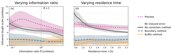
Regional analyses of atmospheric trace gases can improve knowledge of fluxes at high resolution but rely on specified boundary conditions (BCs) at the domain edges. Biases in the often-uncertain BCs propagate to the inferred fluxes. We develop a framework to explain how errors in the BCs influence the optimized fluxes, derive two metrics to estimate this influence, and compare two methods to correct for the biases. We demonstrate correcting BCs directly is more effective at reducing bias.
Riley Duren, Daniel Cusworth, Alana Ayasse, Katherine Howell, Alex Diamond, Tia Scarpelli, Jinsol Kim, Kelly O'neill, Judy Lai-Norling, Andrew Thorpe, Sander R. Zandbergen, Lucas Shaw, Mark Keremedjiev, Jeff Guido, Paul Giuliano, Malkam Goldstein, Ravi Nallapu, Geert Barentsen, David R. Thompson, Keely Roth, Daniel Jensen, Michael Eastwood, Frances Reuland, Taylor Adams, Adam Brandt, Eric A. Kort, James Mason, and Robert O. Green
Atmos. Meas. Tech., 18, 6933–6958, https://doi.org/10.5194/amt-18-6933-2025, https://doi.org/10.5194/amt-18-6933-2025, 2025
Short summary
Short summary
We describe the Carbon Mapper emissions monitoring system including methane and carbon dioxide observations from the constellation of Tanager hyperspectral satellites, a global monitoring strategy optimized for enabling mitigation impact at the scale of individual facilities, and a data platform that delivers timely and transparent information for diverse stakeholders. We present early findings from Tanager-1 including the use of our data to locate and repair a leaking oil and gas pipeline.
Lucas A. Estrada, Daniel J. Varon, Melissa Sulprizio, Hannah Nesser, Zichong Chen, Nicholas Balasus, Sarah E. Hancock, Megan He, James D. East, Todd A. Mooring, Alexander Oort Alonso, Joannes D. Maasakkers, Ilse Aben, Sabour Baray, Kevin W. Bowman, John R. Worden, Felipe J. Cardoso-Saldaña, Emily Reidy, and Daniel J. Jacob
Geosci. Model Dev., 18, 3311–3330, https://doi.org/10.5194/gmd-18-3311-2025, https://doi.org/10.5194/gmd-18-3311-2025, 2025
Short summary
Short summary
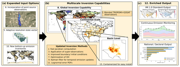
Reducing emissions of methane, a powerful greenhouse gas, is a top policy concern for mitigating anthropogenic climate change. The Integrated Methane Inversion (IMI) is an advanced, cloud-based software that translates satellite observations into actionable emissions data. Here we present IMI version 2.0 with vastly expanded capabilities. These updates enable a wider range of scientific and stakeholder applications from individual basin to global scales with continuous emissions monitoring.
Elise Penn, Daniel J. Jacob, Zichong Chen, James D. East, Melissa P. Sulprizio, Lori Bruhwiler, Joannes D. Maasakkers, Hannah Nesser, Zhen Qu, Yuzhong Zhang, and John Worden
Atmos. Chem. Phys., 25, 2947–2965, https://doi.org/10.5194/acp-25-2947-2025, https://doi.org/10.5194/acp-25-2947-2025, 2025
Short summary
Short summary
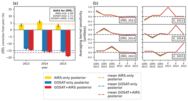
The hydroxyl radical (OH) destroys many air pollutants, including methane. Global-mean OH cannot be directly measured, and thus it is inferred with the methyl chloroform (MCF) proxy. MCF is decreasing, and a replacement is needed. We use satellite observations of methane in two spectral ranges as a proxy for OH. We find shortwave infrared observations can characterize yearly OH and its seasonality but not the latitudinal distribution. Thermal infrared observations add little information.
Sarah E. Hancock, Daniel J. Jacob, Zichong Chen, Hannah Nesser, Aaron Davitt, Daniel J. Varon, Melissa P. Sulprizio, Nicholas Balasus, Lucas A. Estrada, María Cazorla, Laura Dawidowski, Sebastián Diez, James D. East, Elise Penn, Cynthia A. Randles, John Worden, Ilse Aben, Robert J. Parker, and Joannes D. Maasakkers
Atmos. Chem. Phys., 25, 797–817, https://doi.org/10.5194/acp-25-797-2025, https://doi.org/10.5194/acp-25-797-2025, 2025
Short summary
Short summary
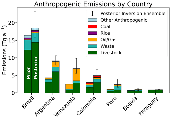
We quantify 2021 methane emissions in South America at up to 25 km × 25 km resolution using satellite methane observations. We find a 55 % upward adjustment to anthropogenic emission inventories, including those reported to the UN Framework Convention on Climate Change under the Paris Agreement. Our estimates match inventories for Brazil, Bolivia, and Paraguay but are much higher for other countries. Livestock emissions (65 % of anthropogenic emissions) show the largest discrepancies.
Gijs Leguijt, Joannes D. Maasakkers, Hugo A. C. Denier van der Gon, Arjo J. Segers, Tobias Borsdorff, Ivar R. van der Velde, and Ilse Aben
Atmos. Chem. Phys., 25, 555–574, https://doi.org/10.5194/acp-25-555-2025, https://doi.org/10.5194/acp-25-555-2025, 2025
Short summary
Short summary
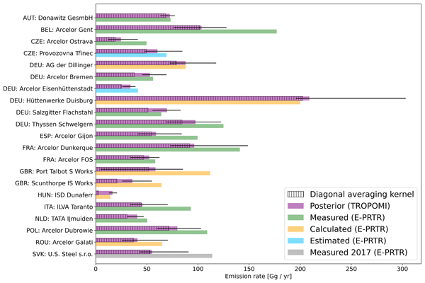
The production of steel coincides with large emissions of greenhouse gases and air pollutants including carbon monoxide. European facilities are required to report their emissions, which are estimated using a variety of methods. We evaluate these estimates using carbon monoxide concentrations measured via satellite. We find generally good agreement between our values and those reported but also identify some uncertainties, showing that satellites can provide insights into these emissions.
Cynthia D. Nevison, Qing Liang, Paul A. Newman, Britton B. Stephens, Geoff Dutton, Xin Lan, Roisin Commane, Yenny Gonzalez, and Eric Kort
Atmos. Chem. Phys., 24, 10513–10529, https://doi.org/10.5194/acp-24-10513-2024, https://doi.org/10.5194/acp-24-10513-2024, 2024
Short summary
Short summary
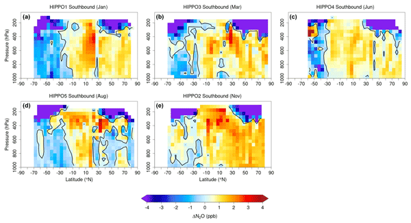
This study examines the drivers of interannual variability in tropospheric N2O. New insights are obtained from aircraft data and a chemistry–climate model that explicitly simulates stratospheric N2O. The stratosphere is found to be the dominant driver of N2O variability in the Northern Hemisphere, while both the stratosphere and El Niño cycles are important in the Southern Hemisphere. These results are consistent with known atmospheric dynamics and differences between the hemispheres.
Brian Nathan, Joannes D. Maasakkers, Stijn Naus, Ritesh Gautam, Mark Omara, Daniel J. Varon, Melissa P. Sulprizio, Lucas A. Estrada, Alba Lorente, Tobias Borsdorff, Robert J. Parker, and Ilse Aben
Atmos. Chem. Phys., 24, 6845–6863, https://doi.org/10.5194/acp-24-6845-2024, https://doi.org/10.5194/acp-24-6845-2024, 2024
Short summary
Short summary
Venezuela's Lake Maracaibo region is notoriously hard to observe from space and features intensive oil exploitation, although production has strongly decreased in recent years. We estimate methane emissions using 2018–2020 TROPOMI satellite observations with national and regional transport models. Despite the production decrease, we find relatively constant emissions from Lake Maracaibo between 2018 and 2020, indicating that there could be large emissions from abandoned infrastructure.
Matthieu Dogniaux, Joannes D. Maasakkers, Daniel J. Varon, and Ilse Aben
Atmos. Meas. Tech., 17, 2777–2787, https://doi.org/10.5194/amt-17-2777-2024, https://doi.org/10.5194/amt-17-2777-2024, 2024
Short summary
Short summary
We analyze Landsat 8 (L8) and Sentinel-2B (S-2B) observations of the 2022 Nord Stream 2 methane leak and show how challenging this case is for usual data analysis methods. We provide customized calibrations for this Nord Stream 2 case and assess that no firm conclusion can be drawn from L8 or S-2B single overpasses. However, if we opportunistically assume that L8 and S-2B results are independent, we find an averaged L8 and S-2B combined methane leak rate of 502 ± 464 t h−1.
Hannah Nesser, Daniel J. Jacob, Joannes D. Maasakkers, Alba Lorente, Zichong Chen, Xiao Lu, Lu Shen, Zhen Qu, Melissa P. Sulprizio, Margaux Winter, Shuang Ma, A. Anthony Bloom, John R. Worden, Robert N. Stavins, and Cynthia A. Randles
Atmos. Chem. Phys., 24, 5069–5091, https://doi.org/10.5194/acp-24-5069-2024, https://doi.org/10.5194/acp-24-5069-2024, 2024
Short summary
Short summary
We quantify 2019 methane emissions in the contiguous US (CONUS) at a ≈ 25 km × 25 km resolution using satellite methane observations. We find a 13 % upward correction to the 2023 US Environmental Protection Agency (EPA) Greenhouse Gas Emissions Inventory (GHGI) for 2019, with large corrections to individual states, urban areas, and landfills. This may present a challenge for US climate policies and goals, many of which target significant reductions in methane emissions.
Evan D. Sherwin, Sahar H. El Abbadi, Philippine M. Burdeau, Zhan Zhang, Zhenlin Chen, Jeffrey S. Rutherford, Yuanlei Chen, and Adam R. Brandt
Atmos. Meas. Tech., 17, 765–782, https://doi.org/10.5194/amt-17-765-2024, https://doi.org/10.5194/amt-17-765-2024, 2024
Short summary
Short summary
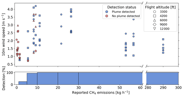
Countries and companies increasingly rely on a growing fleet of satellites to find large emissions of climate-warming methane, particularly from oil and natural gas systems across the globe. We independently assessed the performance of nine such systems by releasing controlled, undisclosed amounts of methane as satellites passed overhead. The tested systems produced reliable detection and quantification results, including the smallest-ever emission detected from space in such a test.
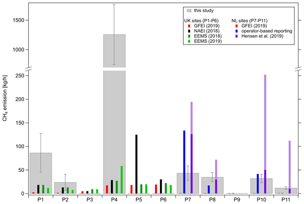
Magdalena Pühl, Anke Roiger, Alina Fiehn, Alan M. Gorchov Negron, Eric A. Kort, Stefan Schwietzke, Ignacio Pisso, Amy Foulds, James Lee, James L. France, Anna E. Jones, Dave Lowry, Rebecca E. Fisher, Langwen Huang, Jacob Shaw, Prudence Bateson, Stephen Andrews, Stuart Young, Pamela Dominutti, Tom Lachlan-Cope, Alexandra Weiss, and Grant Allen
Atmos. Chem. Phys., 24, 1005–1024, https://doi.org/10.5194/acp-24-1005-2024, https://doi.org/10.5194/acp-24-1005-2024, 2024
Short summary
Short summary
In April–May 2019 we carried out an airborne field campaign in the southern North Sea with the aim of studying methane emissions of offshore gas installations. We determined methane emissions from elevated methane measured downstream of the sampled installations. We compare our measured methane emissions with estimated methane emissions from national and global annual inventories. As a result, we find inconsistencies of inventories and large discrepancies between measurements and inventories.
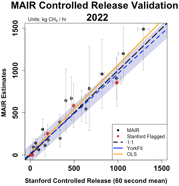
Apisada Chulakadabba, Maryann Sargent, Thomas Lauvaux, Joshua S. Benmergui, Jonathan E. Franklin, Christopher Chan Miller, Jonas S. Wilzewski, Sébastien Roche, Eamon Conway, Amir H. Souri, Kang Sun, Bingkun Luo, Jacob Hawthrone, Jenna Samra, Bruce C. Daube, Xiong Liu, Kelly Chance, Yang Li, Ritesh Gautam, Mark Omara, Jeff S. Rutherford, Evan D. Sherwin, Adam Brandt, and Steven C. Wofsy
Atmos. Meas. Tech., 16, 5771–5785, https://doi.org/10.5194/amt-16-5771-2023, https://doi.org/10.5194/amt-16-5771-2023, 2023
Short summary
Short summary
We show that MethaneAIR, a precursor to the MethaneSAT satellite, demonstrates accurate point source quantification during controlled release experiments and regional observations in 2021 and 2022. Results from our two independent quantification methods suggest the accuracy of our sensor and algorithms is better than 25 % for sources emitting 200 kg h−1 or more. Insights from these measurements help establish the capabilities of MethaneSAT and MethaneAIR.
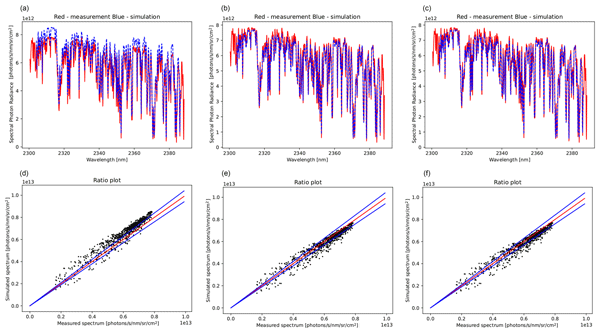
Tim A. van Kempen, Tim J. Rotmans, Richard M. van Hees, Carol Bruegge, Dejian Fu, Ruud Hoogeveen, Thomas J. Pongetti, Robert Rosenberg, and Ilse Aben
Atmos. Meas. Tech., 16, 4507–4527, https://doi.org/10.5194/amt-16-4507-2023, https://doi.org/10.5194/amt-16-4507-2023, 2023
Short summary
Short summary
Validation of satellite measurements is essential for providing reliable and consistent products. In this paper, a validation method for TROPOMI-SWIR (Tropospheric Measurement Instrument in the short-wavelength infrared) is explored. TROPOMI-SWIR has been shown to be exceptionally stable, a necessity to explore the methodology. Railroad Valley, Nevada, is a prime location to perform the necessary measurements to validate the satellite measurements of TROPOMI-SWIR.
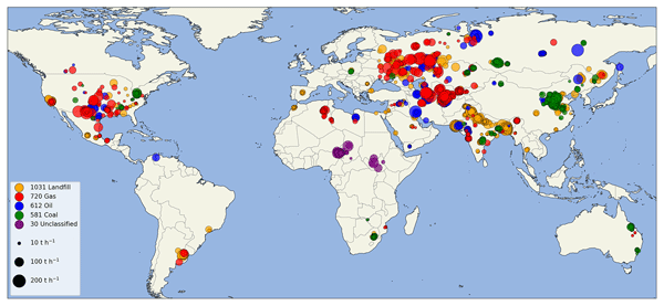
Berend J. Schuit, Joannes D. Maasakkers, Pieter Bijl, Gourav Mahapatra, Anne-Wil van den Berg, Sudhanshu Pandey, Alba Lorente, Tobias Borsdorff, Sander Houweling, Daniel J. Varon, Jason McKeever, Dylan Jervis, Marianne Girard, Itziar Irakulis-Loitxate, Javier Gorroño, Luis Guanter, Daniel H. Cusworth, and Ilse Aben
Atmos. Chem. Phys., 23, 9071–9098, https://doi.org/10.5194/acp-23-9071-2023, https://doi.org/10.5194/acp-23-9071-2023, 2023
Short summary
Short summary
Using two machine learning models, which were trained on TROPOMI methane satellite data, we detect 2974 methane plumes, so-called super-emitters, in 2021. We detect methane emissions globally related to urban areas or landfills, coal mining, and oil and gas production. Using our monitoring system, we identify 94 regions with frequent emissions. For 12 locations, we target high-resolution satellite instruments to enlarge and identify the exact infrastructure responsible for the emissions.
Nicholas Balasus, Daniel J. Jacob, Alba Lorente, Joannes D. Maasakkers, Robert J. Parker, Hartmut Boesch, Zichong Chen, Makoto M. Kelp, Hannah Nesser, and Daniel J. Varon
Atmos. Meas. Tech., 16, 3787–3807, https://doi.org/10.5194/amt-16-3787-2023, https://doi.org/10.5194/amt-16-3787-2023, 2023
Short summary
Short summary
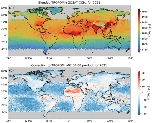
We use machine learning to remove biases in TROPOMI satellite observations of atmospheric methane, with GOSAT observations serving as a reference. We find that the TROPOMI biases relative to GOSAT are related to the presence of aerosols and clouds, the surface brightness, and the specific detector that makes the observation aboard TROPOMI. The resulting blended TROPOMI+GOSAT product is more reliable for quantifying methane emissions.
Gijs Leguijt, Joannes D. Maasakkers, Hugo A. C. Denier van der Gon, Arjo J. Segers, Tobias Borsdorff, and Ilse Aben
Atmos. Chem. Phys., 23, 8899–8919, https://doi.org/10.5194/acp-23-8899-2023, https://doi.org/10.5194/acp-23-8899-2023, 2023
Short summary
Short summary
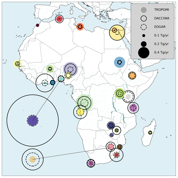
We present a fast method to evaluate carbon monoxide emissions from cities in Africa. Carbon monoxide is important for climate change in an indirect way, as it is linked to ozone, methane, and carbon dioxide. Our measurements are made with a satellite that sees the entire globe every single day. This means that we can check from space whether the current knowledge of emission rates is up to date. We make the comparison and show that the emission rates in northern Africa are underestimated.
Ruosi Liang, Yuzhong Zhang, Wei Chen, Peixuan Zhang, Jingran Liu, Cuihong Chen, Huiqin Mao, Guofeng Shen, Zhen Qu, Zichong Chen, Minqiang Zhou, Pucai Wang, Robert J. Parker, Hartmut Boesch, Alba Lorente, Joannes D. Maasakkers, and Ilse Aben
Atmos. Chem. Phys., 23, 8039–8057, https://doi.org/10.5194/acp-23-8039-2023, https://doi.org/10.5194/acp-23-8039-2023, 2023
Short summary
Short summary
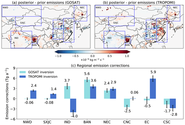
We compare and evaluate East Asian methane emissions inferred from different satellite observations (GOSAT and TROPOMI). The results show discrepancies over northern India and eastern China. Independent ground-based observations are more consistent with TROPOMI-derived emissions in northern India and GOSAT-derived emissions in eastern China.
Daniel J. Varon, Daniel J. Jacob, Benjamin Hmiel, Ritesh Gautam, David R. Lyon, Mark Omara, Melissa Sulprizio, Lu Shen, Drew Pendergrass, Hannah Nesser, Zhen Qu, Zachary R. Barkley, Natasha L. Miles, Scott J. Richardson, Kenneth J. Davis, Sudhanshu Pandey, Xiao Lu, Alba Lorente, Tobias Borsdorff, Joannes D. Maasakkers, and Ilse Aben
Atmos. Chem. Phys., 23, 7503–7520, https://doi.org/10.5194/acp-23-7503-2023, https://doi.org/10.5194/acp-23-7503-2023, 2023
Short summary
Short summary
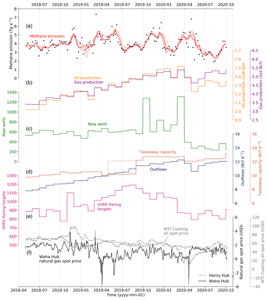
We use TROPOMI satellite observations to quantify weekly methane emissions from the US Permian oil and gas basin from May 2018 to October 2020. We find that Permian emissions are highly variable, with diverse economic and activity drivers. The most important drivers during our study period were new well development and natural gas price. Permian methane intensity averaged 4.6 % and decreased by 1 % per year.
Xiumei Zhang, Ronald van der A, Jieying Ding, Xin Zhang, and Yan Yin
Atmos. Chem. Phys., 23, 5587–5604, https://doi.org/10.5194/acp-23-5587-2023, https://doi.org/10.5194/acp-23-5587-2023, 2023
Short summary
Short summary
We compiled a ship emission inventory based on automatic identification system (AIS) signals in the Jiangsu section of the Yangtze River. This ship emission inventory was compared with Chinese bottom-up inventories and the satellite-derived emissions from TROPOMI. The result shows a consistent spatial distribution, with riverine cities having high NOx emissions. Inland ship emissions of NOx are shown to contribute at least 40 % to air pollution along the river.
Anna Agustí-Panareda, Jérôme Barré, Sébastien Massart, Antje Inness, Ilse Aben, Melanie Ades, Bianca C. Baier, Gianpaolo Balsamo, Tobias Borsdorff, Nicolas Bousserez, Souhail Boussetta, Michael Buchwitz, Luca Cantarello, Cyril Crevoisier, Richard Engelen, Henk Eskes, Johannes Flemming, Sébastien Garrigues, Otto Hasekamp, Vincent Huijnen, Luke Jones, Zak Kipling, Bavo Langerock, Joe McNorton, Nicolas Meilhac, Stefan Noël, Mark Parrington, Vincent-Henri Peuch, Michel Ramonet, Miha Razinger, Maximilian Reuter, Roberto Ribas, Martin Suttie, Colm Sweeney, Jérôme Tarniewicz, and Lianghai Wu
Atmos. Chem. Phys., 23, 3829–3859, https://doi.org/10.5194/acp-23-3829-2023, https://doi.org/10.5194/acp-23-3829-2023, 2023
Short summary
Short summary
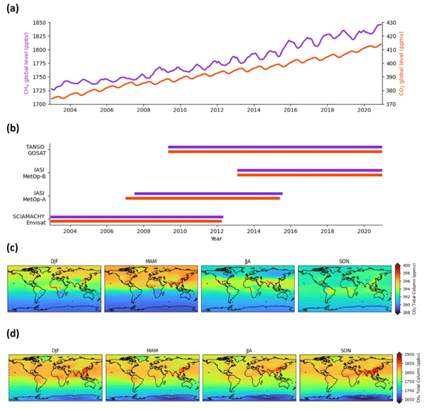
We present a global dataset of atmospheric CO2 and CH4, the two most important human-made greenhouse gases, which covers almost 2 decades (2003–2020). It is produced by combining satellite data of CO2 and CH4 with a weather and air composition prediction model, and it has been carefully evaluated against independent observations to ensure validity and point out deficiencies to the user. This dataset can be used for scientific studies in the field of climate change and the global carbon cycle.
Srijana Lama, Sander Houweling, K. Folkert Boersma, Ilse Aben, Hugo A. C. Denier van der Gon, and Maarten C. Krol
Atmos. Chem. Phys., 22, 16053–16071, https://doi.org/10.5194/acp-22-16053-2022, https://doi.org/10.5194/acp-22-16053-2022, 2022
Short summary
Short summary
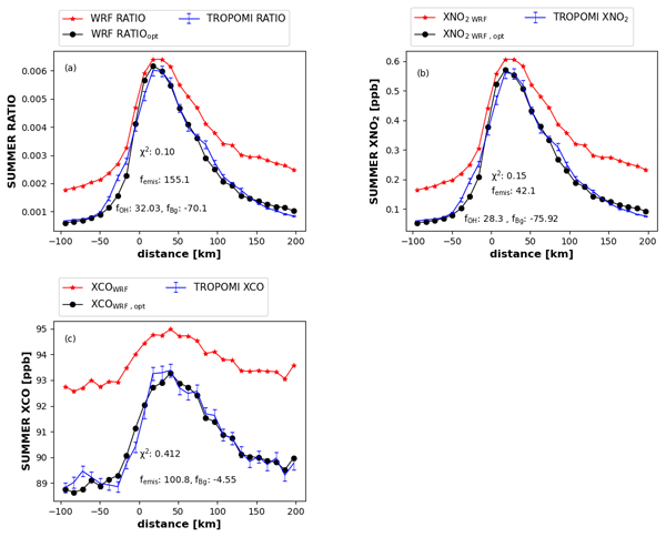
Hydroxyl radical (OH) is the important chemical species that determines the lifetime of some greenhouse gases and trace gases. OH plays a vital role in air pollution chemistry. OH has a short lifetime and is extremely difficult to measure directly. OH concentrations derived from the chemistry transport model (CTM) have uncertainties of >50 %. Therefore, in this study, OH is derived indirectly using satellite date in urban plumes.
Zhan Zhang, Evan D. Sherwin, Daniel J. Varon, and Adam R. Brandt
Atmos. Meas. Tech., 15, 7155–7169, https://doi.org/10.5194/amt-15-7155-2022, https://doi.org/10.5194/amt-15-7155-2022, 2022
Short summary
Short summary
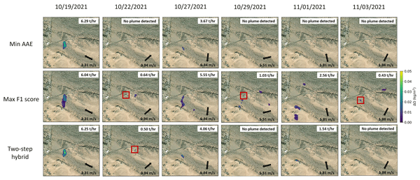
This work developed a multi-band–multi-pass–multi-comparison-date Sentinel-2 methane retrieval algorithm, and the method was calibrated by data from a controlled release test. To our knowledge, this is the first study that validates the performance of a Sentinel-2 methane detection algorithm by calibration with a ground-truth testing. It illustrates the potential for additional validation with systematic future experiments wherein algorithms can be tuned to meet different detection expectations.

Antje Inness, Ilse Aben, Melanie Ades, Tobias Borsdorff, Johannes Flemming, Luke Jones, Jochen Landgraf, Bavo Langerock, Philippe Nedelec, Mark Parrington, and Roberto Ribas
Atmos. Chem. Phys., 22, 14355–14376, https://doi.org/10.5194/acp-22-14355-2022, https://doi.org/10.5194/acp-22-14355-2022, 2022
Short summary
Short summary
The Copernicus Atmosphere Monitoring Service (CAMS) provides daily global air quality forecasts to users worldwide. One of the species of interest is carbon monoxide (CO), an important trace gas in the atmosphere with anthropogenic and natural sources, produced by incomplete combustion, for example, by wildfires. This paper looks at how well CAMS can model CO in the atmosphere and shows that the fields can be improved when blending CO data from the TROPOMI instrument with the CAMS model.
Lu Shen, Ritesh Gautam, Mark Omara, Daniel Zavala-Araiza, Joannes D. Maasakkers, Tia R. Scarpelli, Alba Lorente, David Lyon, Jianxiong Sheng, Daniel J. Varon, Hannah Nesser, Zhen Qu, Xiao Lu, Melissa P. Sulprizio, Steven P. Hamburg, and Daniel J. Jacob
Atmos. Chem. Phys., 22, 11203–11215, https://doi.org/10.5194/acp-22-11203-2022, https://doi.org/10.5194/acp-22-11203-2022, 2022
Short summary
Short summary
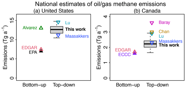
We use 22 months of TROPOMI satellite observations to quantity methane emissions from the oil (O) and natural gas (G) sector in the US and Canada at the scale of both individual basins as well as country-wide aggregates. We find that O/G-related methane emissions are underestimated in these inventories by 80 % for the US and 40 % for Canada, and 70 % of the underestimate in the US is from five O/G basins, including Permian, Haynesville, Anadarko, Eagle Ford, and Barnett.
Sara Martínez-Alonso, Merritt N. Deeter, Bianca C. Baier, Kathryn McKain, Helen Worden, Tobias Borsdorff, Colm Sweeney, and Ilse Aben
Atmos. Meas. Tech., 15, 4751–4765, https://doi.org/10.5194/amt-15-4751-2022, https://doi.org/10.5194/amt-15-4751-2022, 2022
Short summary
Short summary
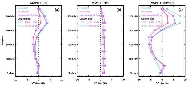
AirCore is a novel balloon sampling system that can measure, among others, vertical profiles of carbon monoxide (CO) from 25–30 km of altitude to near the surface. Our analyses of AirCore and satellite CO data show that AirCore profiles are suited for satellite data validation, the use of shorter aircraft vertical profiles in satellite validation results in small errors (1–3 percent points) mostly at 300 hPa and above, and the error introduced by clouds in TROPOMI land data is small (1–2 %).
Pieternel F. Levelt, Deborah C. Stein Zweers, Ilse Aben, Maite Bauwens, Tobias Borsdorff, Isabelle De Smedt, Henk J. Eskes, Christophe Lerot, Diego G. Loyola, Fabian Romahn, Trissevgeni Stavrakou, Nicolas Theys, Michel Van Roozendael, J. Pepijn Veefkind, and Tijl Verhoelst
Atmos. Chem. Phys., 22, 10319–10351, https://doi.org/10.5194/acp-22-10319-2022, https://doi.org/10.5194/acp-22-10319-2022, 2022
Short summary
Short summary
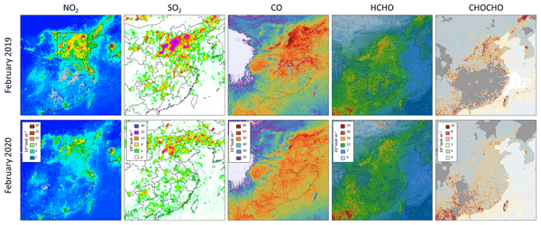
Using the COVID-19 lockdown periods as an example, we show how Sentinel-5P/TROPOMI trace gas data (NO2, SO2, CO, HCHO and CHOCHO) can be used to understand impacts on air quality for regions and cities around the globe. We also provide information for both experienced and inexperienced users about how we created the data using state-of-the-art algorithms, where to get the data, methods taking meteorological and seasonal variability into consideration, and insights for future studies.
John R. Worden, Daniel H. Cusworth, Zhen Qu, Yi Yin, Yuzhong Zhang, A. Anthony Bloom, Shuang Ma, Brendan K. Byrne, Tia Scarpelli, Joannes D. Maasakkers, David Crisp, Riley Duren, and Daniel J. Jacob
Atmos. Chem. Phys., 22, 6811–6841, https://doi.org/10.5194/acp-22-6811-2022, https://doi.org/10.5194/acp-22-6811-2022, 2022
Short summary
Short summary
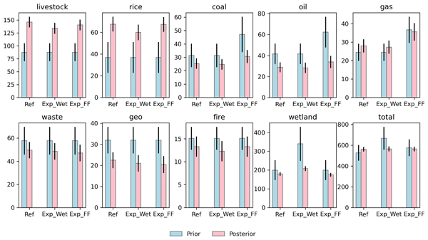
This paper is intended to accomplish two goals: 1) describe a new algorithm by which remotely sensed measurements of methane or other tracers can be used to not just quantify methane fluxes, but also attribute these fluxes to specific sources and regions and characterize their uncertainties, and 2) use this new algorithm to provide methane emissions by sector and country in support of the global stock take.
Dustin Roten, John C. Lin, Lewis Kunik, Derek Mallia, Dien Wu, Tomohiro Oda, and Eric A. Kort
Atmos. Chem. Phys. Discuss., https://doi.org/10.5194/acp-2022-315, https://doi.org/10.5194/acp-2022-315, 2022
Revised manuscript not accepted
Short summary
Short summary
The systems used to monitor carbon dioxide (CO2) emissions from urban areas provides a means to observe and quantify emissions reductions from policy-related reduction efforts. Space-based instruments, such as NASA's Orbiting Carbon Observatory-3 (OCO-3), provides detailed "snapshots" of CO2 emissions from many megacities around the world. This work quantifies the amount of emission "information" contained in these snapshots and uses this information to update previous estimates of urban CO2.
Xin Zhang, Yan Yin, Ronald van der A, Henk Eskes, Jos van Geffen, Yunyao Li, Xiang Kuang, Jeff L. Lapierre, Kui Chen, Zhongxiu Zhen, Jianlin Hu, Chuan He, Jinghua Chen, Rulin Shi, Jun Zhang, Xingrong Ye, and Hao Chen
Atmos. Chem. Phys., 22, 5925–5942, https://doi.org/10.5194/acp-22-5925-2022, https://doi.org/10.5194/acp-22-5925-2022, 2022
Short summary
Short summary
The importance of convection to the ozone and nitrogen oxides (NOx) produced from lightning has long been an open question. We utilize the high-resolution chemistry model with ozonesondes and space observations to discuss the effects of convection over southeastern China, where few studies have been conducted. Our results show the transport and chemistry contributions for various storms and demonstrate the ability of TROPOMI to estimate the lightning NOx production over small-scale convection.
Jennifer D. Hegarty, Karen E. Cady-Pereira, Vivienne H. Payne, Susan S. Kulawik, John R. Worden, Valentin Kantchev, Helen M. Worden, Kathryn McKain, Jasna V. Pittman, Róisín Commane, Bruce C. Daube Jr., and Eric A. Kort
Atmos. Meas. Tech., 15, 205–223, https://doi.org/10.5194/amt-15-205-2022, https://doi.org/10.5194/amt-15-205-2022, 2022
Short summary
Short summary
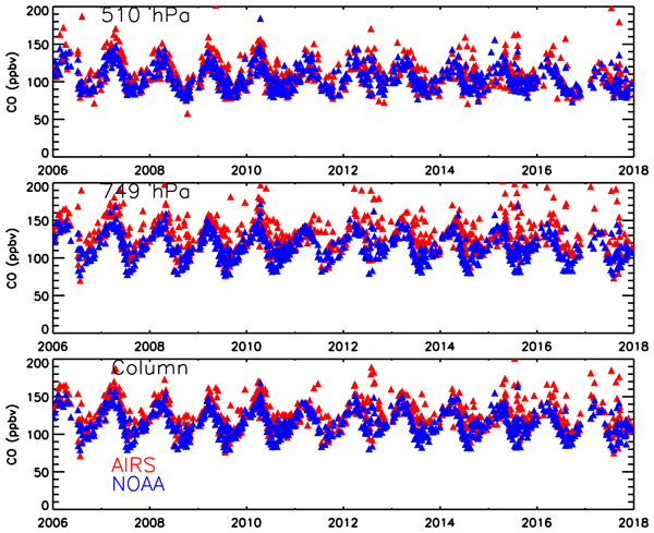
Carbon monoxide (CO) is produced by combustion of substances such as fossil fuels and plays an important role in atmospheric pollution and climate. We evaluated estimates of atmospheric CO derived from outgoing radiation measurements of the Atmospheric Infrared Sounder (AIRS) on a satellite orbiting the Earth against CO measurements from aircraft to show that these satellite measurements are reliable for continuous global monitoring of atmospheric CO concentrations.

Xiao Lu, Daniel J. Jacob, Haolin Wang, Joannes D. Maasakkers, Yuzhong Zhang, Tia R. Scarpelli, Lu Shen, Zhen Qu, Melissa P. Sulprizio, Hannah Nesser, A. Anthony Bloom, Shuang Ma, John R. Worden, Shaojia Fan, Robert J. Parker, Hartmut Boesch, Ritesh Gautam, Deborah Gordon, Michael D. Moran, Frances Reuland, Claudia A. Octaviano Villasana, and Arlyn Andrews
Atmos. Chem. Phys., 22, 395–418, https://doi.org/10.5194/acp-22-395-2022, https://doi.org/10.5194/acp-22-395-2022, 2022
Short summary
Short summary
We evaluate methane emissions and trends for 2010–2017 in the gridded national emission inventories for the United States, Canada, and Mexico by inversion of in situ and satellite methane observations. We find that anthropogenic methane emissions for all three countries are underestimated in the national inventories, largely driven by oil emissions. Anthropogenic methane emissions in the US peak in 2014, in contrast to the report of a steadily decreasing trend over 2010–2017 from the US EPA.
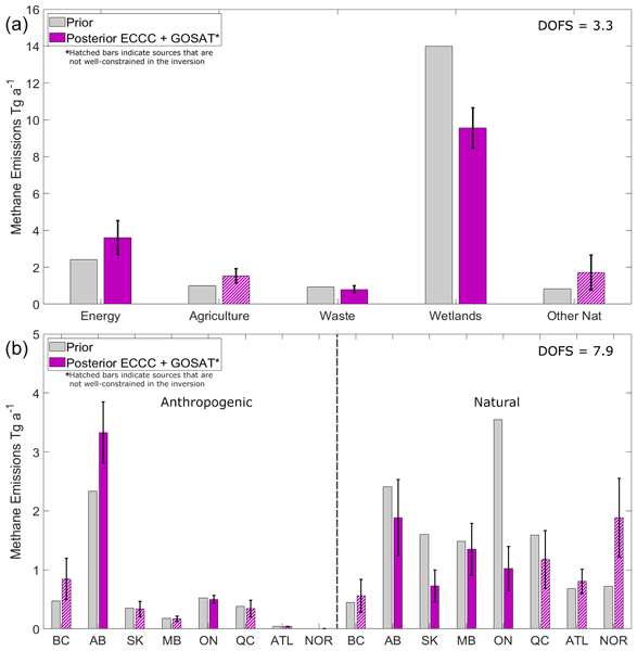
Sabour Baray, Daniel J. Jacob, Joannes D. Maasakkers, Jian-Xiong Sheng, Melissa P. Sulprizio, Dylan B. A. Jones, A. Anthony Bloom, and Robert McLaren
Atmos. Chem. Phys., 21, 18101–18121, https://doi.org/10.5194/acp-21-18101-2021, https://doi.org/10.5194/acp-21-18101-2021, 2021
Short summary
Short summary
We use 2010–2015 surface and satellite observations to disentangle methane from anthropogenic and natural sources in Canada. Using a chemical transport model (GEOS-Chem), the mismatch between modelled and observed methane concentrations can be used to infer emissions according to Bayesian statistics. Compared to prior knowledge, we show higher anthropogenic emissions attributed to energy and/or agriculture in Western Canada and lower natural emissions from Boreal wetlands.
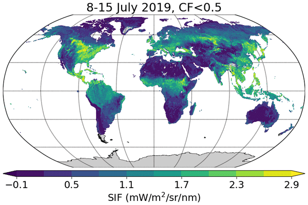
Luis Guanter, Cédric Bacour, Andreas Schneider, Ilse Aben, Tim A. van Kempen, Fabienne Maignan, Christian Retscher, Philipp Köhler, Christian Frankenberg, Joanna Joiner, and Yongguang Zhang
Earth Syst. Sci. Data, 13, 5423–5440, https://doi.org/10.5194/essd-13-5423-2021, https://doi.org/10.5194/essd-13-5423-2021, 2021
Short summary
Short summary
Sun-induced chlorophyll fluorescence (SIF) is an electromagnetic signal emitted by plants in the red and far-red parts of the spectrum. It has a functional link to photosynthesis and can be measured by satellite instruments, which makes it an important variable for the remote monitoring of the photosynthetic activity of vegetation ecosystems around the world. In this contribution we present a SIF dataset derived from the new Sentinel-5P TROPOMI missions.
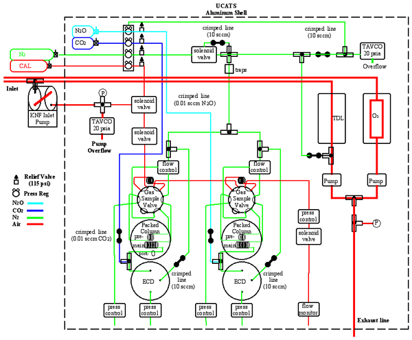
Eric J. Hintsa, Fred L. Moore, Dale F. Hurst, Geoff S. Dutton, Bradley D. Hall, J. David Nance, Ben R. Miller, Stephen A. Montzka, Laura P. Wolton, Audra McClure-Begley, James W. Elkins, Emrys G. Hall, Allen F. Jordan, Andrew W. Rollins, Troy D. Thornberry, Laurel A. Watts, Chelsea R. Thompson, Jeff Peischl, Ilann Bourgeois, Thomas B. Ryerson, Bruce C. Daube, Yenny Gonzalez Ramos, Roisin Commane, Gregory W. Santoni, Jasna V. Pittman, Steven C. Wofsy, Eric Kort, Glenn S. Diskin, and T. Paul Bui
Atmos. Meas. Tech., 14, 6795–6819, https://doi.org/10.5194/amt-14-6795-2021, https://doi.org/10.5194/amt-14-6795-2021, 2021
Short summary
Short summary
We built UCATS to study atmospheric chemistry and transport. It has measured trace gases including CFCs, N2O, SF6, CH4, CO, and H2 with gas chromatography, as well as ozone and water vapor. UCATS has been part of missions to study the tropical tropopause; transport of air into the stratosphere; greenhouse gases, transport, and chemistry in the troposphere; and ozone chemistry, on both piloted and unmanned aircraft. Its design, capabilities, and some results are shown and described here.
Cited articles
Batson, J. and Royer, L.: Noise2Self: Blind Denoising by Self-Supervision, arXiv [preprint], https://doi.org/10.48550/arXiv.1901.11365, 2019. a
Boggs, T., March, D., kormang, McGibbney, L. J., Magimel, F., Mason, G., Banman, K., Uzumaki), M. J. L., Kumar, R., Badger, T. G., Aarnio, T., Wang, W., and kidpixo: Spectralpython/Spectral: Spectral Python (Spy) 0.23.1, Zenodo [code], https://doi.org/10.5281/zenodo.7135091, 2022. a
Borchardt, J., Gerilowski, K., Krautwurst, S., Bovensmann, H., Thorpe, A. K., Thompson, D. R., Frankenberg, C., Miller, C. E., Duren, R. M., and Burrows, J. P.: Detection and Quantification of CH4 Plumes Using the WFM-DOAS Retrieval on AVIRIS-NG Hyperspectral Data, Atmos. Meas. Tech., 14, 1267–1291, https://doi.org/10.5194/amt-14-1267-2021, 2021. a
Borger, C., Beirle, S., Butz, A., Scheidweiler, L. O., and Wagner, T.: High-Resolution Observations of NO2 and CO2 Emission Plumes from EnMAP Satellite Measurements, Environ. Res. Lett., 20, 044034, https://doi.org/10.1088/1748-9326/adc0b1, 2025. a, b
Brandt, A., Reuland, F., Adams, T., Sherwin, E., Abbadi, S. E., and Kort, E.: Unlocking Credible Space-Based Methane Sensing through a Year-Long Single-Blind Test, Research Square, https://doi.org/10.21203/rs.3.rs-9110475/v1, 2026. a
Brodrick, P., winstonolson, jfahlen, Chlus, A., and Thompson, D. R.: Emit-Sds/Emit-Ghg: V0.3.8, Zenodo [code], https://doi.org/10.5281/zenodo.18379923, 2026. a
Brunner, D., Kuhlmann, G., Marshall, J., Clément, V., Fuhrer, O., Broquet, G., Löscher, A., and Meijer, Y.: Accounting for the Vertical Distribution of Emissions in Atmospheric CO2 Simulations, Atmos. Chem. Phys., 19, 4541–4559, https://doi.org/10.5194/acp-19-4541-2019, 2019. a
Carver, R. W. and Merose, A.: ARCO-ERA5: An Analysis-Ready Cloud-Optimized Reanalysis Dataset, in: 103rd AMS Annual Meeting, AMS, https://ams.confex.com/ams/103ANNUAL/meetingapp.cgi/Paper/415842 (last access: 22 June 2026), 2023. a
Cawse-Nicholson, K., Townsend, P. A., Schimel, D., Assiri, A. M., Blake, P. L., Buongiorno, M. F., Campbell, P., Carmon, N., Casey, K. A., Correa-Pabón, R. E., Dahlin, K. M., Dashti, H., Dennison, P. E., Dierssen, H., Erickson, A., Fisher, J. B., Frouin, R., Gatebe, C. K., Gholizadeh, H., Gierach, M., Glenn, N. F., Goodman, J. A., Griffith, D. M., Guild, L., Hakkenberg, C. R., Hochberg, E. J., Holmes, T. R. H., Hu, C., Hulley, G., Huemmrich, K. F., Kudela, R. M., Kokaly, R. F., Lee, C. M., Martin, R., Miller, C. E., Moses, W. J., Muller-Karger, F. E., Ortiz, J. D., Otis, D. B., Pahlevan, N., Painter, T. H., Pavlick, R., Poulter, B., Qi, Y., Realmuto, V. J., Roberts, D., Schaepman, M. E., Schneider, F. D., Schwandner, F. M., Serbin, S. P., Shiklomanov, A. N., Stavros, E. N., Thompson, D. R., Torres-Perez, J. L., Turpie, K. R., Tzortziou, M., Ustin, S., Yu, Q., Yusup, Y., and Zhang, Q.: NASA's Surface Biology and Geology Designated Observable: A Perspective on Surface Imaging Algorithms, Remote Sens. Environ., 257, 112349, https://doi.org/10.1016/j.rse.2021.112349, 2021. a, b
Chambolle, A.: An Algorithm for Total Variation Minimization and Applications, J. Math. Imag. Vis., 20, 89–97, https://doi.org/10.1023/B:JMIV.0000011325.36760.1e, 2004. a
Cogliati, S., Sarti, F., Chiarantini, L., Cosi, M., Lorusso, R., Lopinto, E., Miglietta, F., Genesio, L., Guanter, L., Damm, A., Pérez-López, S., Scheffler, D., Tagliabue, G., Panigada, C., Rascher, U., Dowling, T. P. F., Giardino, C., and Colombo, R.: The PRISMA Imaging Spectroscopy Mission: Overview and First Performance Analysis, Remote Sens. Environ., 262, 112499, https://doi.org/10.1016/j.rse.2021.112499, 2021. a
Cusworth, D. H., Thorpe, A. K., Miller, C. E., Ayasse, A. K., Jiorle, R., Duren, R. M., Nassar, R., Mastrogiacomo, J.-P., and Nelson, R. R.: Two Years of Satellite-Based Carbon Dioxide Emission Quantification at the World's Largest Coal-Fired Power Plants, Atmos. Chem. Phys., 23, 14577–14591, https://doi.org/10.5194/acp-23-14577-2023, 2023. a, b
De Luca, G., Carotenuto, F., Genesio, L., Pepe, M., Toscano, P., Boschetti, M., Miglietta, F., and Gioli, B.: Improving PRISMA Hyperspectral Spatial Resolution and Geolocation by Using Sentinel-2: Development and Test of an Operational Procedure in Urban and Rural Areas, ISPRS J. Photogram. Remote Sens., 215, 112–135, https://doi.org/10.1016/j.isprsjprs.2024.07.003, 2024. a
DLR – German Aerospace Center: EOWEB GeoPortal, https://eoweb.dlr.de/ (last access: 22 June 2026), 2026. a
Duren, R., Cusworth, D., Ayasse, A., Howell, K., Diamond, A., Scarpelli, T., Kim, J., O'neill, K., Lai-Norling, J., Thorpe, A., Zandbergen, S. R., Shaw, L., Keremedjiev, M., Guido, J., Giuliano, P., Goldstein, M., Nallapu, R., Barentsen, G., Thompson, D. R., Roth, K., Jensen, D., Eastwood, M., Reuland, F., Adams, T., Brandt, A., Kort, E. A., Mason, J., and Green, R. .: The Carbon Mapper Emissions Monitoring System, Atmos. Meas. Tech., 18, 6933–6958, https://doi.org/10.5194/amt-18-6933-2025, 2025. a, b, c
Duren, R. M., Thorpe, A. K., Foster, K. T., Rafiq, T., Hopkins, F. M., Yadav, V., Bue, B. D., Thompson, D. R., Conley, S., Colombi, N. K., Frankenberg, C., McCubbin, I. B., Eastwood, M. L., Falk, M., Herner, J. D., Croes, B. E., Green, R. O., and Miller, C. E.: California's Methane Super-Emitters, Nature, 575, 180–184, https://doi.org/10.1038/s41586-019-1720-3, 2019. a
Elson, P., de Andrade, E. S., Lucas, G., May, R., Hattersley, R., Campbell, E., Comer, R., Dawson, A., Little, B., Raynaud, S., scmc72, Snow, A. D., lgolston, Blay, B., Killick, P., lbdreyer, Peglar, P., Wilson, N., Andrew, Szymaniak, J., Berchet, A., Bosley, C., Davis, L., Filipe, Krasting, J., Bradbury, M., stephenworsley, and Kirkham, D.: SciTools/Cartopy: REL: V0.24.1, Zenodo [code], https://doi.org/10.5281/zenodo.13905945, 2024. a
Esri, Maxar, Geographics, E., and the GIS User Community: ESRI World Imagery, https://services.arcgisonline.com/ArcGIS/rest/services/World_Imagery/MapServer (last access: 22 June 2026), 2022. a
Feng, C., Chen, S., Zeng, Z.-C., Luo, Y., Natraj, V., and Yung, Y. L.: Aerosol-Calibrated Matched Filter Method for Retrievals of Methane Point Source Emissions Over the Los Angeles Basin, Earth Space Sci., 11, e2024EA003519, https://doi.org/10.1029/2024EA003519, 2024. a
Ferrari, A., Pampanoni, V., Laneve, G., Tellez, R. A. C., and Saquella, S.: A Multi-Sensor Framework for Methane Detection and Flux Estimation with Scale-Aware Plume Segmentation and Uncertainty Propagation from High-Resolution Spaceborne Imaging Spectrometers, Methane, 5, https://doi.org/10.3390/methane5010010, 2026. a
Foote, M. D., Dennison, P. E., Thorpe, A. K., Thompson, D. R., Jongaramrungruang, S., Frankenberg, C., and Joshi, S. C.: Fast and Accurate Retrieval of Methane Concentration From Imaging Spectrometer Data Using Sparsity Prior, IEEE T. Geosci. Remote, 58, 6480–6492, https://doi.org/10.1109/TGRS.2020.2976888, 2020. a, b, c
Foote, M. D., Dennison, P. E., Sullivan, P. R., O'Neill, K. B., Thorpe, A. K., Thompson, D. R., Cusworth, D. H., Duren, R., and Joshi, S. C.: Impact of Scene-Specific Enhancement Spectra on Matched Filter Greenhouse Gas Retrievals from Imaging Spectroscopy, Remote Sens. Environ., 264, 112574, https://doi.org/10.1016/j.rse.2021.112574, 2021. a, b
Funk, C., Theiler, J., Roberts, D., and Borel, C.: Clustering to Improve Matched Filter Detection of Weak Gas Plumes in Hyperspectral Thermal Imagery, IEEE T. Geosci. Remote, 39, 1410–1420, https://doi.org/10.1109/36.934073, 2001. a, b, c
Gloudemans, A. M. S., Schrijver, H., Hasekamp, O. P., and Aben, I.: Error Analysis for CO and CH4 Total Column Retrievals from SCIAMACHY 2.3 µm Spectra, Atmos. Chem. Phys., 8, 3999–4017, https://doi.org/10.5194/acp-8-3999-2008, 2008. a
GMAO and NASA: GMAO Data Products, https://gmao.gsfc.nasa.gov/GMAO_products/ (last access: 22 June 2026), 2026. a
Green, R.: EMIT L1B At-Sensor Calibrated Radiance and Geolocation Data 60 m V001, NASA, https://doi.org/10.5067/EMIT/EMITL1BRAD.001, 2022. a
Green, R. O., Mahowald, N., Ung, C., Thompson, D. R., Bator, L., Bennet, M., Bernas, M., Blackway, N., Bradley, C., Cha, J., Clark, P., Clark, R., Cloud, D., Diaz, E., Ben Dor, E., Duren, R., Eastwood, M., Ehlmann, B. L., Fuentes, L., Ginoux, P., Gross, J., He, Y., Kalashnikova, O., Kert, W., Keymeulen, D., Klimesh, M., Ku, D., Kwong-Fu, H., Liggett, E., Li, L., Lundeen, S., Makowski, M. D., Mazer, A., Miller, R., Mouroulis, P., Oaida, B., Okin, G. S., Ortega, A., Oyake, A., Nguyen, H., Pace, T., Painter, T. H., Pempejian, J., Garcia-Pando, C. P., Pham, T., Phillips, B., Pollock, R., Purcell, R., Realmuto, V., Schoolcraft, J., Sen, A., Shin, S., Shaw, L., Soriano, M., Swayze, G., Thingvold, E., Vaid, A., and Zan, J.: The Earth Surface Mineral Dust Source Investigation: An Earth Science Imaging Spectroscopy Mission, in: 2020 IEEE Aerospace Conference, 1–15, https://doi.org/10.1109/AERO47225.2020.9172731, 2020. a
Green, R. O., Mahowald, N., Thompson, D. R., Ung, C., Brodrick, P., Pollock, R., Bennett, M., Lundeen, S., Joyce, M., Olson-Duvall, W., Oaida, B., Bradley, C., Diaz, E., Clark, R., Vannan, S., Swayze, G., Kokaly, R., Ginoux, P., Miller, R., Okin, G., Garcia-Pando, C. P., Ehlmann, B., Kalashnikova, O., Painter, T. H., Realmuto, V., Chadwick, D., Ben-Dor, E., Pearlshtien, D. H., Guanter, L., Phillips, B., Reath, K., Thorpe, A., Shaw, L., Keebler, A., Ochoa, F., Grant, K., Sen, A., Duren, R., Obiso, V., Gonçalves-Ageitos, M., and Huang, Y.: Performance and Early Results from the Earth Surface Mineral Dust Source Investigation (EMIT) Imaging Spectroscopy Mission, in: 2023 IEEE Aerospace Conference, 1–10, https://doi.org/10.1109/AERO55745.2023.10115851, 2023. a
Guanter, L., Segl, K., Sang, B., Alonso, L., Kaufmann, H., and Moreno, J.: Scene-Based Spectral Calibration Assessment of High Spectral Resolution Imaging Spectrometers, Opt. Express, 17, 11594–11606, https://doi.org/10.1364/OE.17.011594, 2009. a
Guanter, L., Kaufmann, H., Segl, K., Foerster, S., Rogass, C., Chabrillat, S., Kuester, T., Hollstein, A., Rossner, G., Chlebek, C., Straif, C., Fischer, S., Schrader, S., Storch, T., Heiden, U., Mueller, A., Bachmann, M., Mühle, H., Müller, R., Habermeyer, M., Ohndorf, A., Hill, J., Buddenbaum, H., Hostert, P., Van der Linden, S., Leitão, P. J., Rabe, A., Doerffer, R., Krasemann, H., Xi, H., Mauser, W., Hank, T., Locherer, M., Rast, M., Staenz, K., and Sang, B.: The EnMAP Spaceborne Imaging Spectroscopy Mission for Earth Observation, Remote Sens., 7, 8830–8857, https://doi.org/10.3390/rs70708830, 2015. a
Guanter, L., Irakulis-Loitxate, I., Gorroño, J., Sánchez-García, E., Cusworth, D. H., Varon, D. J., Cogliati, S., and Colombo, R.: Mapping Methane Point Emissions with the PRISMA Spaceborne Imaging Spectrometer, Remote Sens. Environ., 265, 112671, https://doi.org/10.1016/j.rse.2021.112671, 2021. a, b, c, d, e
Hakkarainen, J., Ialongo, I., Varon, D. J., Kuhlmann, G., and Krol, M. C.: Linear Integrated Mass Enhancement: A Method for Estimating Hotspot Emission Rates from Space-Based Plume Observations, Remote Sens. Environ., 319, 114623, https://doi.org/10.1016/j.rse.2025.114623, 2025. a
Han, G., Pei, Z., Shi, T., Mao, H., Li, S., Mao, F., Ma, X., Zhang, X., and Gong, W.: Unveiling Unprecedented Methane Hotspots in China's Leading Coal Production Hub: A Satellite Mapping Revelation, Geophys. Res. Lett., 51, e2024GL109065, https://doi.org/10.1029/2024GL109065, 2024. a
Heikenfeld, M., Marinescu, P. J., Christensen, M., Watson-Parris, D., Senf, F., van den Heever, S. C., and Stier, P.: Tobac 1.2: Towards a Flexible Framework for Tracking and Analysis of Clouds in Diverse Datasets, Geosci. Model Dev., 12, 4551–4570, https://doi.org/10.5194/gmd-12-4551-2019, 2019. a
Hersbach, H., Bell, B., Berrisford, P., Hirahara, S., Horányi, A., Muñoz-Sabater, J., Nicolas, J., Peubey, C., Radu, R., Schepers, D., Simmons, A., Soci, C., Abdalla, S., Abellan, X., Balsamo, G., Bechtold, P., Biavati, G., Bidlot, J., Bonavita, M., Chiara, G., Dahlgren, P., Dee, D., Diamantakis, M., Dragani, R., Flemming, J., Forbes, R., Fuentes, M., Geer, A., Haimberger, L., Healy, S., Hogan, R. J., Hólm, E., Janisková, M., Keeley, S., Laloyaux, P., Lopez, P., Lupu, C., Radnoti, G., Rosnay, P., Rozum, I., Vamborg, F., Villaume, S., and Thépaut, J.-N.: The ERA5 Global Reanalysis, Q. J. Roy. Meteorol. Soc., 146, 1999–2049, https://doi.org/10.1002/qj.3803, 2020. a
Hersbach, H., Bell, B., Berrisford, P., Biavati, G., Horányi, A., Muñoz Sabater, J., Nicolas, J., Peubey, C., Radu, R., Rozum, I., Schepers, D., Simmons, A., Soci, C., Dee, D., and Thépaut, J.-N.: ERA5 Hourly Data on Single Levels from 1940 to Present, CDS [data set], https://doi.org/10.24381/cds.adbb2d47, 2023. a
Hoyer, S. and Hamman, J. J.: Xarray: N-D Labeled Arrays and Datasets in Python, J. Open Res. Softw., 5, 10, https://doi.org/10.5334/jors.148, 2017. a
IPCC – Intergovernmental Panel on Climate Change: Climate Change 2021 – The Physical Science Basis: Working Group I Contribution to the Sixth Assessment Report of the Intergovernmental Panel on Climate Change, Cambridge University Press, Cambridge, https://doi.org/10.1017/9781009157896, 2023. a
Italian Space Agency: PRISMA Portal, https://prisma.asi.it/ (last access: 22 June 2026), 2026. a
Jacob, D. J., Varon, D. J., Cusworth, D. H., Dennison, P. E., Frankenberg, C., Gautam, R., Guanter, L., Kelley, J., McKeever, J., Ott, L. E., Poulter, B., Qu, Z., Thorpe, A. K., Worden, J. R., and Duren, R. M.: Quantifying Methane Emissions from the Global Scale down to Point Sources Using Satellite Observations of Atmospheric Methane, Atmos. Chem. Phys., 22, 9617–9646, https://doi.org/10.5194/acp-22-9617-2022, 2022. a, b
Kennedy, J. H., Smale, J., Johnston, A., Kristenson, H., Player, A., cirrusasf, Herrmann, J., Williams, F., Rine, J., and Logan, T.: ASFHyP3/Asf-Tools: ASF Tools v0.7.2, Zenodo [code], https://doi.org/10.5281/zenodo.10845708, 2024. a
Krings, T., Gerilowski, K., Buchwitz, M., Reuter, M., Tretner, A., Erzinger, J., Heinze, D., Pflüger, U., Burrows, J. P., and Bovensmann, H.: MAMAP – a New Spectrometer System for Column-Averaged Methane and Carbon Dioxide Observations from Aircraft: Retrieval Algorithm and First Inversions for Point Source Emission Rates, Atmos. Meas. Tech., 4, 1735–1758, https://doi.org/10.5194/amt-4-1735-2011, 2011. a
Kuhlmann, G., Koene, E., Meier, S., Santaren, D., Broquet, G., Chevallier, F., Hakkarainen, J., Nurmela, J., Amorós, L., Tamminen, J., and Brunner, D.: The Ddeq Python Library for Point Source Quantification from Remote Sensing Images (Version 1.0), Geosci. Model Dev., 17, 4773–4789, https://doi.org/10.5194/gmd-17-4773-2024, 2024. a, b, c
Liu, Y.-N., Sun, D.-X., Hu, X.-N., Ye, X., Li, Y.-D., Liu, S.-F., Cao, K.-Q., Chai, M.-Y., Zhou, W.-Y.-N., Zhang, J., Zhang, Y., Sun, W.-W., and Jiao, L.-L.: The Advanced Hyperspectral Imager: Aboard China's GaoFen-5 Satellite, IEEE Geosci. Remote Sens. Mag., 7, 23–32, https://doi.org/10.1109/MGRS.2019.2927687, 2019. a
Loizzo, R., Guarini, R., Longo, F., Scopa, T., Formaro, R., Facchinetti, C., and Varacalli, G.: Prisma: The Italian Hyperspectral Mission, in: IGARSS 2018–2018 IEEE International Geoscience and Remote Sensing Symposium, 175–178, https://doi.org/10.1109/IGARSS.2018.8518512, 2018. a
Maasakkers, J. D., Varon, D. J., Elfarsdóttir, A., McKeever, J., Jervis, D., Mahapatra, G., Pandey, S., Lorente, A., Borsdorff, T., Foorthuis, L. R., Schuit, B. J., Tol, P., van Kempen, T. A., van Hees, R., and Aben, I.: Using Satellites to Uncover Large Methane Emissions from Landfills, Sci. Adv., 8, eabn9683, https://doi.org/10.1126/sciadv.abn9683, 2022. a, b, c, d
Pearlman, J., Carman, S., Segal, C., Jarecke, P., Clancy, P., and Browne, W.: Overview of the Hyperion Imaging Spectrometer for the NASA EO-1 Mission, in: IGARSS 2001. Scanning the Present and Resolving the Future. Proceedings. IEEE 2001 International Geoscience and Remote Sensing Symposium (Cat. No. 01CH37217), vol. 7, 3036–3038, https://doi.org/10.1109/IGARSS.2001.978246, 2001. a
Pei, Z., Han, G., Mao, H., Chen, C., Shi, T., Yang, K., Ma, X., and Gong, W.: Improving Quantification of Methane Point Source Emissions from Imaging Spectroscopy, Remote Sens. Environ., 295, 113652, https://doi.org/10.1016/j.rse.2023.113652, 2023. a, b
Qian, S.-E.: Hyperspectral Satellites, Evolution, and Development History, IEEE J. Select. Top. Appl. Earth Obs. Remote Sens., 14, 7032–7056, https://doi.org/10.1109/JSTARS.2021.3090256, 2021. a
Raspaud, M., Hoese, D., Lahtinen, P., Holl, G., Proud, S., Finkensieper, S., Meraner, A., Dybbroe, A., Strandgren, J., yukaribbba, Lahtinen, P., Feltz, J., BENR0, Joro, S., Zhang, X., de Buyl, P., Youva, Ghiggi, G., Roberts, W., Rasmussen, L. Ø., ClementLaplace, Samain, O., mherbertson, Zhu, Y., Méndez, J. H. B., Isotr0py, seenno, rdaruwala, and bkremmli: Pytroll/Satpy: Version 0.59.0 (2025/11/07), Zenodo [code], https://doi.org/10.5281/zenodo.17552484, 2025. a
Rast, M., Nieke, J., Adams, J., Isola, C., and Gascon, F.: Copernicus Hyperspectral Imaging Mission for the Environment (Chime), in: 2021 IEEE International Geoscience and Remote Sensing Symposium IGARSS, 108–111, https://doi.org/10.1109/IGARSS47720.2021.9553319, 2021. a, b, c
Reuland, F., Adams, T., Galvin, K., Kort, E. A., and Brandt, A. R.: Large-Scale Controlled Methane Releases for Satellite-Based Detection and Emission Quantification of Point-Sources, Stanford University, https://doi.org/10.25740/qh001qt3946, 2025. a
Roger, J., Guanter, L., Gorroño, J., and Irakulis-Loitxate, I.: Exploiting the Entire Near-Infrared Spectral Range to Improve the Detection of Methane Plumes with High-Resolution Imaging Spectrometers, Atmos. Meas. Tech., 17, 1333–1346, https://doi.org/10.5194/amt-17-1333-2024, 2024. a, b, c
Sadavarte, P., Pandey, S., Maasakkers, J. D., Lorente, A., Borsdorff, T., Denier van der Gon, H., Houweling, S., and Aben, I.: Methane Emissions from Superemitting Coal Mines in Australia Quantified Using TROPOMI Satellite Observations, Environ. Sci. Technol., 55, 16573–16580, https://doi.org/10.1021/acs.est.1c03976, 2021. a
Schaum, A.: A Uniformly Most Powerful Detector of Gas Plumes against a Cluttered Background, Remote Sens. Environ., 260, 112443, https://doi.org/10.1016/j.rse.2021.112443, 2021. a
Sherwin, E. D., Rutherford, J. S., Chen, Y., Aminfard, S., Kort, E. A., Jackson, R. B., and Brandt, A. R.: Single-Blind Validation of Space-Based Point-Source Detection and Quantification of Onshore Methane Emissions, Sci. Rep., 13, 3836, https://doi.org/10.1038/s41598-023-30761-2, 2023. a
Sherwin, E. D., El Abbadi, S. H., Burdeau, P. M., Zhang, Z., Chen, Z., Rutherford, J. S., Chen, Y., and Brandt, A. R.: Single-Blind Test of Nine Methane-Sensing Satellite Systems from Three Continents, Atmos. Meas. Tech., 17, 765–782, https://doi.org/10.5194/amt-17-765-2024, 2024. a
Storch, T., Honold, H.-P., Chabrillat, S., Habermeyer, M., Tucker, P., Brell, M., Ohndorf, A., Wirth, K., Betz, M., Kuchler, M., Mühle, H., Carmona, E., Baur, S., Mücke, M., Löw, S., Schulze, D., Zimmermann, S., Lenzen, C., Wiesner, S., Aida, S., Kahle, R., Willburger, P., Hartung, S., Dietrich, D., Plesia, N., Tegler, M., Schork, K., Alonso, K., Marshall, D., Gerasch, B., Schwind, P., Pato, M., Schneider, M., de los Reyes, R., Langheinrich, M., Wenzel, J., Bachmann, M., Holzwarth, S., Pinnel, N., Guanter, L., Segl, K., Scheffler, D., Foerster, S., Bohn, N., Bracher, A., Soppa, M. A., Gascon, F., Green, R., Kokaly, R., Moreno, J., Ong, C., Sornig, M., Wernitz, R., Bagschik, K., Reintsema, D., La Porta, L., Schickling, A., and Fischer, S.: The EnMAP Imaging Spectroscopy Mission towards Operations, Remote Sens. Environ., 294, 113632, https://doi.org/10.1016/j.rse.2023.113632, 2023. a
Thompson, D. R., Leifer, I., Bovensmann, H., Eastwood, M., Fladeland, M., Frankenberg, C., Gerilowski, K., Green, R. O., Kratwurst, S., Krings, T., Luna, B., and Thorpe, A. K.: Real-Time Remote Detection and Measurement for Airborne Imaging Spectroscopy: A Case Study with Methane, Atmos. Meas. Tech., 8, 4383–4397, https://doi.org/10.5194/amt-8-4383-2015, 2015. a, b, c
Thorpe, A. K., Roberts, D. A., Bradley, E. S., Funk, C. C., Dennison, P. E., and Leifer, I.: High Resolution Mapping of Methane Emissions from Marine and Terrestrial Sources Using a Cluster-Tuned Matched Filter Technique and Imaging Spectrometry, Remote Sens. Environ., 134, 305–318, https://doi.org/10.1016/j.rse.2013.03.018, 2013. a
Thorpe, A. K., Frankenberg, C., and Roberts, D. A.: Retrieval Techniques for Airborne Imaging of Methane Concentrations Using High Spatial and Moderate Spectral Resolution: Application to AVIRIS, Atmos. Meas. Tech., 7, 491–506, https://doi.org/10.5194/amt-7-491-2014, 2014. a
Thorpe, A. K., Green, R. O., Thompson, D. R., Brodrick, P. G., Chapman, J. W., Elder, C. D., Irakulis-Loitxate, I., Cusworth, D. H., Ayasse, A. K., Duren, R. M., Frankenberg, C., Guanter, L., Worden, J. R., Dennison, P. E., Roberts, D. A., Chadwick, K. D., Eastwood, M. L., Fahlen, J. E., and Miller, C. E.: Attribution of Individual Methane and Carbon Dioxide Emission Sources Using EMIT Observations from Space, Sci. Adv., 9, eadh2391, https://doi.org/10.1126/sciadv.adh2391, 2023. a, b, c, d, e
Varon, D. J., Jacob, D. J., McKeever, J., Jervis, D., Durak, B. O. A., Xia, Y., and Huang, Y.: Quantifying Methane Point Sources from Fine-Scale Satellite Observations of Atmospheric Methane Plumes, Atmos. Meas. Tech., 11, 5673–5686, https://doi.org/10.5194/amt-11-5673-2018, 2018. a, b, c, d
Varon, D. J., McKeever, J., Jervis, D., Maasakkers, J. D., Pandey, S., Houweling, S., Aben, I., Scarpelli, T., and Jacob, D. J.: Satellite Discovery of Anomalously Large Methane Point Sources From Oil/Gas Production, Geophys. Res. Lett., 46, 13507–13516, https://doi.org/10.1029/2019GL083798, 2019. a, b
Varon, D. J., Jacob, D. J., Jervis, D., and McKeever, J.: Quantifying Time-Averaged Methane Emissions from Individual Coal Mine Vents with GHGSat-D Satellite Observations, Environ. Sci. Technol., 54, 10246–10253, https://doi.org/10.1021/acs.est.0c01213, 2020. a
Zhang, X.: SRON-ESG/HyperGas, Zenodo [code], https://doi.org/10.5281/zenodo.18154956, 2026a (code also available at: https://github.com/SRON-ESG/HyperGas, last access: 22 June 2026). a
Zhang, X.: Dataset for “HyperGas1.0: A Python Package for Analyzing Hyperspectral Data for Greenhouse Gases from Retrieval to Emission Rate Quantification”, Zenodo [data set], https://doi.org/10.5281/zenodo.18162026, 2026b. a
Zhang, X.: Zxdawn/HyperGas-GMD, Zenodo [code], https://doi.org/10.5281/zenodo.17854157, 2026c. a
Zhang, X.: Wind Dataset for “HyperGas1.0: A Python Package for Analyzing Hyperspectral Data for Greenhouse Gases from Retrieval to Emission Rate Quantification”, Zenodo [data set], https://doi.org/10.5281/zenodo.18166595, 2026d. a
Zhang, X., van der A, R., Ding, J., Eskes, H., van Geffen, J., Yin, Y., Anema, J., Vagasky, C., L. Lapierre, J., and Kuang, X.: Spaceborne Observations of Lightning NO2 in the Arctic, Environ. Sci. Technol., 57, 2322–2332, https://doi.org/10.1021/acs.est.2c07988, 2023. a
Zhang, X., Maasakkers, J. D., Roger, J., Guanter, L., Sharma, S., Lama, S., Tol, P., Varon, D. J., Cusworth, D. H., Howell, K., Thorpe, A. K., Brodrick, P. G., and Aben, I.: Global Identification of Solid Waste Methane Super Emitters Using Hyperspectral Satellites, Environ. Sci. Technol., 59, 18134–18145, https://doi.org/10.1021/acs.est.4c14196, 2025. a, b, c, d, e, f, g
Zippenfenig, P.: Open-Meteo.Com Weather API, Zenodo [code], https://doi.org/10.5281/zenodo.7970649, 2023. a
Short summary
Reducing emissions of greenhouse gases such as methane and carbon dioxide is essential for addressing climate change. We developed HyperGas, an open tool that uses hyperspectral satellite images to retrieve and detect greenhouse gas plumes. It helps scientists locate emission sources, estimate their strength, and examine uncertainties through an easy workflow and visual app. Our goal is to make tracking human-made emissions more accurate and accessible, supporting better climate monitoring.
Reducing emissions of greenhouse gases such as methane and carbon dioxide is essential for...


