the Creative Commons Attribution 4.0 License.
the Creative Commons Attribution 4.0 License.
 | 16 May 2024
A global behavioural model of human fire use and management: WHAM! v1.0
Matthew Kasoar
Apostolos Voulgarakis
Cathy Smith
Jay Mistry
James D. A. Millington
Fire is an integral ecosystem process and a major natural source of vegetation disturbance globally. Yet at the same time, humans use and manage fire in diverse ways and for a huge range of purposes. Therefore, it is perhaps unsurprising that a central finding of the first Fire Model Intercomparison Project was simplistic representation of humans is a substantial shortcoming in the fire modules of dynamic global vegetation models (DGVMs). In response to this challenge, we present a novel, global geospatial model that seeks to capture the diversity of human–fire interactions. Empirically grounded with a global database of anthropogenic fire impacts, WHAM! (the Wildfire Human Agency Model) represents the underlying behavioural and land system drivers of human approaches to fire management and their impact on fire regimes. WHAM! is designed to be coupled with DGVMs (JULES-INFERNO in the current instance), such that human and biophysical drivers of fire on Earth, and their interactions, can be captured in process-based models for the first time. Initial outputs from WHAM! presented here are in line with previous evidence suggesting managed anthropogenic fire use is decreasing globally and point to land use intensification as the underlying reason for this phenomenon.
- Article
(4762 KB) - Full-text XML
-
Supplement
(2863 KB) - BibTeX
- EndNote


Fire is a fundamental earth-system process and a key driver of global vegetation dynamics (Pausas et al., 2017). Yet at the same time humans use fire for a large range of purposes (Smith et al., 2022), from disposal of agricultural residue (Lin and Begho, 2022) to social ceremonies (Beaulaton, 2010). Anthropogenic fire management strategies are similarly diverse, spanning preventative strategies such as indigenous patch burning (Laris, 2002) to fire exclusion through industrial fire extinguishing (Eloy et al., 2019a). Furthermore, humans influence fire regimes not only directly, through starting and managing fires, but also indirectly, by altering and fragmenting fuel loads (Harrison et al., 2021; Rosan et al., 2022), for example through road-building (Haas et al., 2022), livestock grazing (Archibald, 2016), and logging (Cochrane and Barber, 2009).
As such, present-day wildfire regimes are best understood as a coupled socio-ecological system (Kelley et al., 2019; Ford et al., 2021), in which people are the largest driver of changes to the frequency, intensity, and extent of fire (Kelly et al., 2020; Andela et al., 2017). Given the extent and diversity of human–fire interactions, it is perhaps not surprising that the recently completed Fire Model Intercomparison Project (FIREMIP; Hantson et al., 2016) found that representation of humans is a substantial shortcoming in current fire-enabled dynamic global vegetation models (DGVMs). Representation of humans was the biggest cause of disparity between model outputs (Teckentrup et al., 2019) and a major contributor to divergence between models and remotely sensed observations (Forkel et al., 2019). Models did not agree on the magnitude or the direction of the anthropogenic influence on burned area over the last century (Teckentrup et al., 2019).
Underlying this issue are DGVMs' simplistic representations of human activity. To this point, inclusion of anthropogenic influences on fire regimes has been limited to globally homogenous functions based on population density and/or GDP (Rabin et al., 2018; Ford et al., 2021). These approaches treat all anthropogenic fires as similar events and therefore do not account for the diverse ways in which humans use and manage fire in contrasting land use systems and underlying socio-ecological contexts. This makes separating the role of biophysical drivers of fire regimes from human fire use and management, and from anthropogenic changes to fuel load, a substantial research challenge (Jones et al., 2022). Indeed, integration of managed anthropogenic fire into models at all scales has been identified as a major step required to “reimagine fire science for the Anthropocene” (Shuman et al., 2022). Lack of adequate representation of humans in DGVMs limits their ability to predict the future of fire on Earth, which, consequently, affects the quality of forecasts of future emissions of carbon and air pollutants in Earth system models (ESMs; Lasslop et al., 2019).
Here, we present a new model that seeks to address this challenge. Drawing on agent-based approaches, the model – WHAM! (Wildfire Human Agency Model) – captures the drivers and distribution of human fire use and management globally. Importantly, it represents the influence of categorical differences in land use systems – arable farming, livestock farming, forestry, and non-extractive land uses such as conservation and recreation – on human fire management strategies.
One reason for currently limited approaches to representing anthropogenic impacts on fire regimes has been a lack of systematic data from which to derive alternative parameterisations (Forkel et al., 2019; Jones et al., 2022). WHAM!'s empirical foundation is the Database of Anthropogenic Fire Impacts (DAFI), which was developed to address this issue (Millington et al., 2022). DAFI contains data from 1809 case studies of human–fire interactions, sourced primarily from the academic literature, as well as the “grey” literature of government and NGO reports. DAFI, which is freely available online (Perkins and Millington, 2021), enables WHAM! to represent the processes that drive human impacts on fire regimes from the bottom up.
A concurrent data issue has been that the majority of anthropogenic fires have not been captured in global-scale Earth observation products (Zhang et al., 2018). Anthropogenic fires are typically small: > 50 % are smaller than the 21 ha size at which MODIS can reliably detect them (Millington et al., 2022). This has made the evaluation of representations of anthropogenic fire challenging, often leading to circular calibration of modelled fire counts and/or burned area to a structurally biased observational record (Teckentrup et al., 2019). However, with recent advances in fine-scale remote sensing of burned area (e.g. Gaveau et al., 2021; Chen et al., 2023), it is now possible to capture much more of the anthropogenic signal. As such, with the combination of DAFI and fine-scale Earth observation products, an independent evaluation of process-based model representation of anthropogenic influences on fire regimes is now possible.
Anthropogenic fire can be broadly categorised into three components: managed fire, unmanaged fires, and escaped fires (UNEP, 2022). For managed fire, Millington et al. (2022) identify seven central modes of anthropogenic fire use, which range from field preparation in shifting cultivation systems to prescribed fire for biodiversity conservation. Unmanaged anthropogenic fire comprises accidental fires from cigarette butts or machinery failure, as well as arson (Scott, 1985). Escaped fire is when a managed fire grows beyond its original purpose to become an unmanaged wildfire (e.g. Cano-Crespo et al., 2015). Of these three categories, calculating burned area from managed anthropogenic fire can be done within WHAM! itself, as a function of the land system and land user objectives. However, the burned area from unmanaged and escaped anthropogenic fires can only be calculated through coupling with a biophysical fire model.
Therefore, as fire regimes emerge from a combination of anthropogenic and biophysical influences, WHAM! has been developed to be coupled with DGVMs, in the first instance JULES-INFERNO, the fire-enabled dynamic global vegetation model in the UK Earth System Model (Mangeon et al., 2016; Burton et al., 2019). This model coupling will allow process-based representations of anthropogenic and biophysical drivers to be integrated to form a cohesive socio-ecological simulation of global fire regimes. In this paper we present WHAM! as a standalone or “isolated” model (sensu Robinson et al., 2018), and so the model evaluation focuses on managed fire, particularly a comparison of cropland fires from WHAM! with the GFED5 crop fires product (Hall et al., 2024). As WHAM! is an empirical model, the performance metrics of statistical parameterisations against DAFI data are also provided (Sect. S3). However, outside of croplands global burned area products do not differentiate between managed and unmanaged fires (Chen et al., 2023), so full evaluation of WHAM! will only be possible after coupling with JULES-INFERNO, when a complete picture of global burned area can be calculated.
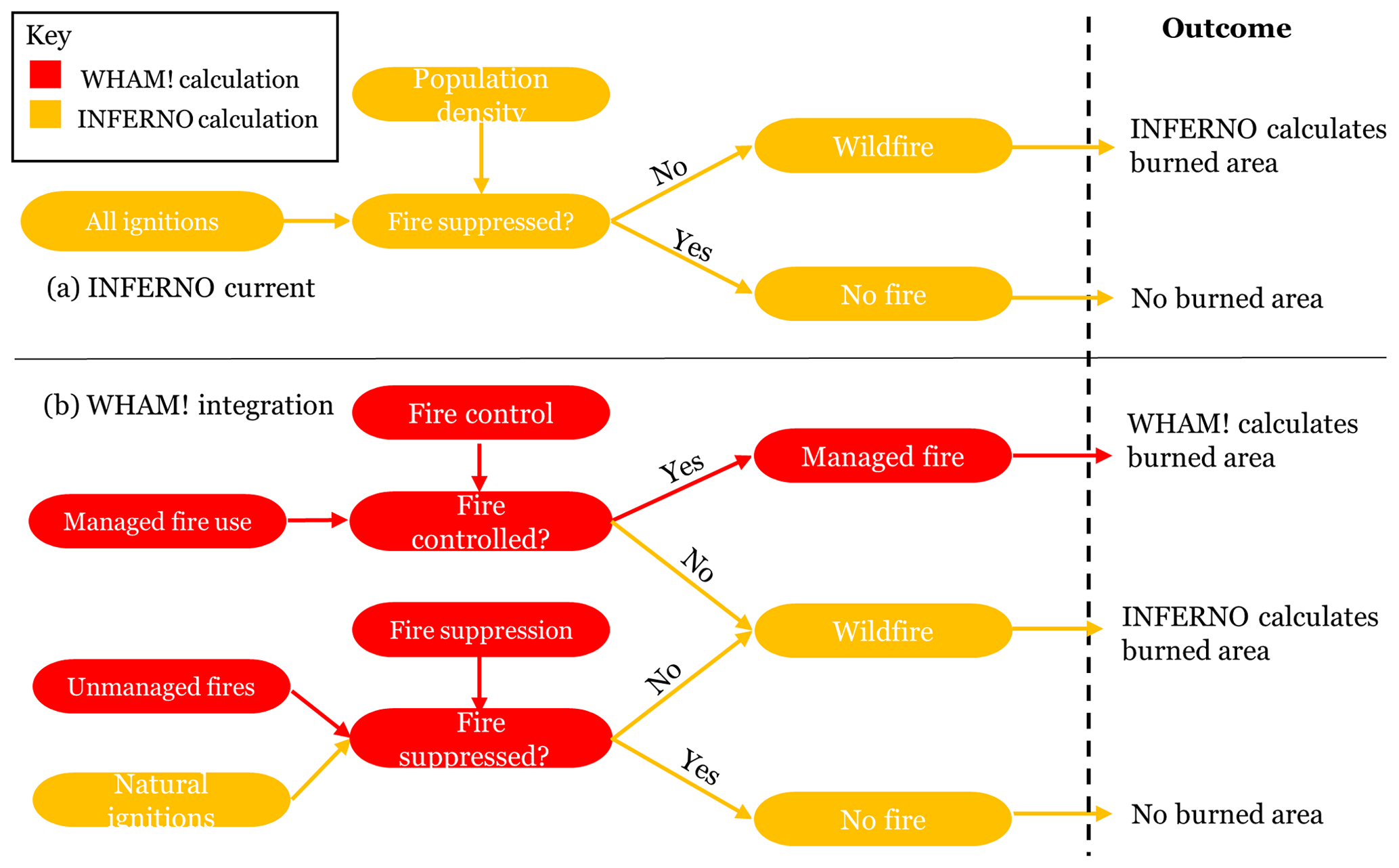
Figure 1From Perkins et al. (2023c): schematic representation of the structural changes to INFERNO enabled by WHAM! integration. Rather than treating all fires as similar events, the WHAM! integration can differentiate between managed fires – which spread primarily according to anthropogenic land management objectives – and unmanaged fires, which spread principally according to biophysical drivers.
To facilitate the planned coupling of WHAM! with JULES-INFERNO, the parameterisation of WHAM! presented in the main text takes relevant biophysical input variables from JULES model outputs. However, as our intention is ultimately that WHAM! can be coupled with multiple fire-enabled DGVMs, we have also parameterised WHAM! using Earth observation products for its biophysical inputs. The differences between the EO-driven version, named “WHAM-EO” (for WHAM! Earth Observation), and the default version of WHAM! are described in Sect. S1 of the Supplement. Some guidance for developers of other DGVMs on how to integrate WHAM! inputs is offered in Sect. S6.
The typical time steps adopted by DGVMs (e.g. hourly or daily) are not relevant for large-scale modelling of human decision-making (Arneth et al., 2014). As such, WHAM! runs at an annual time step, in line with other geospatial land use models run at large spatial extents (e.g. Murray-Rust et al., 2014). WHAM! can be parameterised at different spatial resolutions but is here set up to run at the spatial resolution of JULES adopted in CMIP6 (1.875° × 1.25°; Wiltshire et al., 2020).
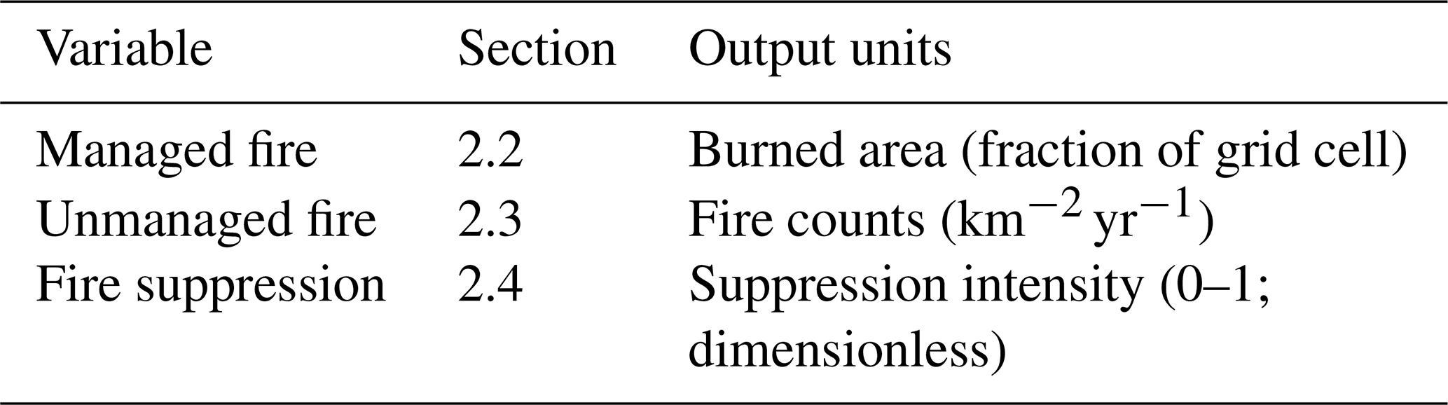
From a model structure perspective, WHAM! replaces globally uniform functions generating numbers of anthropogenic “ignitions” with a process-based representation of anthropogenic fire use and management. An overview of these changes is given in Fig. 1. WHAM! outputs, therefore, are burned area from managed anthropogenic fire as a fraction of each model grid cell, unmanaged anthropogenic fires as number of fires , and fire suppression intensity on a dimensionless scale (0–1; Table 1).
Table 1Overview of WHAM! outputs and respective units; burned area from unmanaged anthropogenic fires – including the impact of fire suppression – will be calculated by a DGVM (initially JULES-INFERNO) as a part of a coupled model ensemble.
WHAM! is presented in the following stages. Firstly, we present the procedure to allocate categorical types of land user spatially (building on Perkins et al., 2022, Sect. 2.1). Secondly, we describe calculation of anthropogenic managed fire (Sect. 2.2) and, thirdly, unmanaged fires (Sect. 2.3). Fire suppression is described in Sect. 2.4. Setup of historical runs and model evaluation are described in Sects. 2.5 and 2.6. WHAM! is written in Python 3.8 using the AgentPy library (Foramitti, 2021). Model code, including forcing data, is made freely available online (Perkins et al., 2023a).
Table 2Agent functional types (AFTs, italicised) and land fire systems (LFSs) resulting from the cross-referencing of land use systems and anthropogenic fire regimes (AFRs). In cases, AFTs are synonymous with LFS, while in the remaining cases the relationship is multi-faceted (and therefore multiple AFTs exist within a LFS as shown by italics).
2.1 Land use in WHAM!
2.1.1 Defining agent functional types
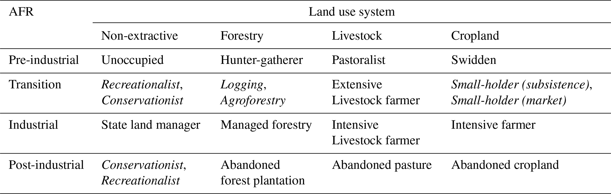
WHAM! is driven by the spatiotemporal distribution and decisions of agent functional types (AFTs; Rounsevell et al., 2012). AFTs are analogous to plant functional types (PFTs) in DGVMs, providing broad categories of function or roles that allow global heterogeneity to be represented in a manageable way (Arneth et al., 2014). The AFTs used are derived from a combination of land use system (LUS) types – cropland, livestock farming, forestry, and non-extractive uses – and from what we term anthropogenic fire regimes (AFRs). The AFRs draw on Pyne's (2019) framing of human–fire interactions and as such are categorical – “pre-industrial”, “transitional”, “industrial”, and “post-industrial” – reflecting available resources and management strategies at a given time and place. The underlying theoretical justification and quantitative signatures of these AFRs, as well as the relationship of the LUS to LUH2 land cover types, are described in Millington et al. (2022) and Perkins et al. (2022). The combination of four land use systems and four anthropogenic fire regimes provides 16 combined land fire systems (LFSs) which in turn can be split into distinct AFTs. In 12 of 16 cases, LFS and AFT are synonymous (Table 2). In the remaining four cases, multiple AFTs compete for space within a single LFS.
2.1.2 Land system distribution
To ensure compatibility under model intercomparison project protocols, WHAM! takes land cover inputs from the LUH2 forcing data sets of Hurtt et al. (2020). Cropland, pasture, rangeland, and urban land cover fractions were taken directly as forcing data. However, to calculate the proportion of tree cover used for forestry versus non-extractive land use, as well as the unoccupied fraction of cell, a process of competition was simulated. This used the same methods as those for the distribution of AFTs, which is described below in Sect. 2.1.3.
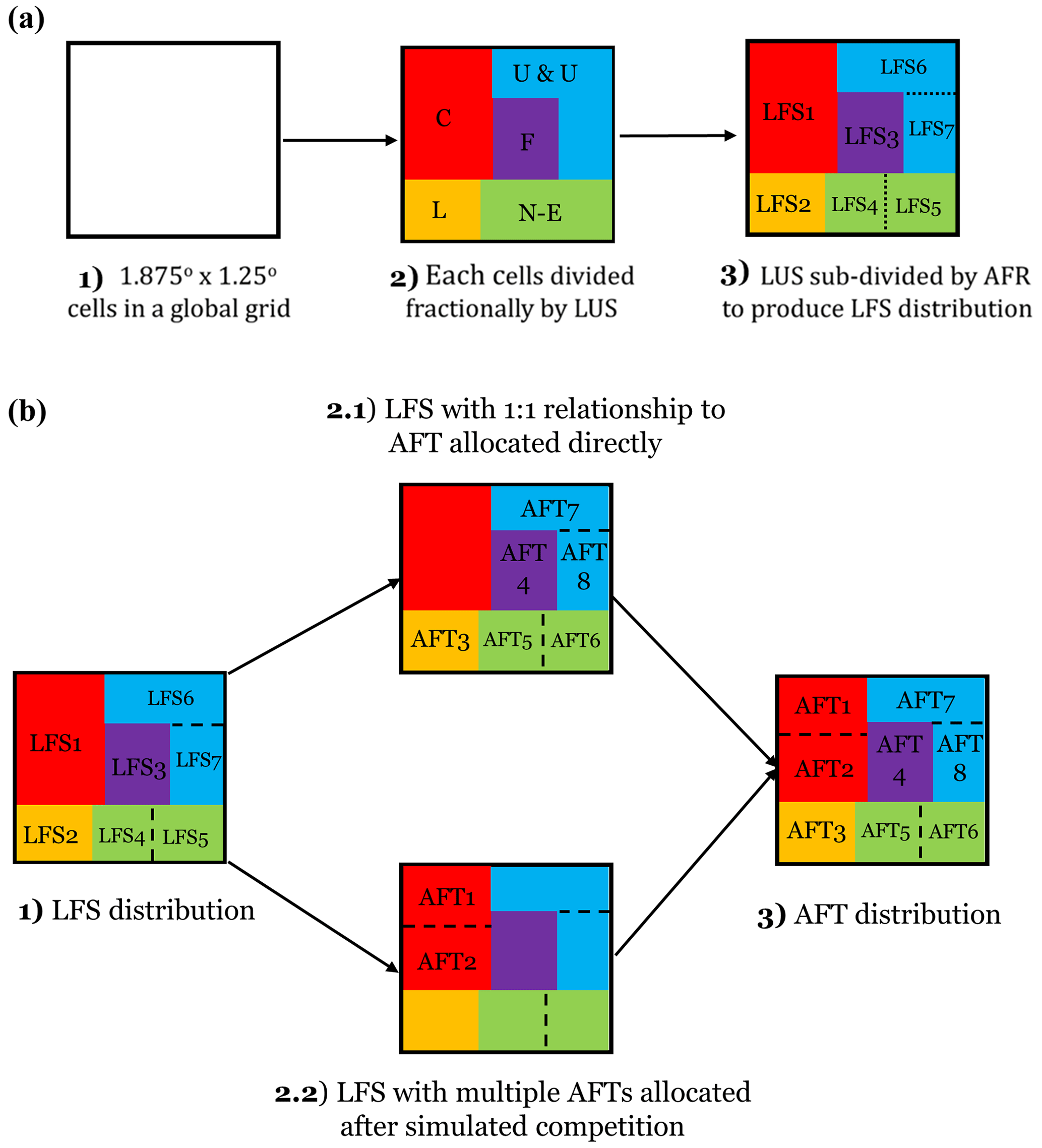
Figure 2Overview of agent functional type (AFT) distribution in WHAM!; (a) describes how cells are divided first into land use systems (LUSs) and then into land fire systems (LFSs). Panel (b) then describes the relationship of land fire systems to AFTs. Key: C – cropland, L – livestock, N-E – non-extractive, F – forestry, U & U – urban and unoccupied.
2.1.3 Agent functional type distribution
The global spatiotemporal distribution of AFTs is based on a simulation of their competition for land. After Arneth et al. (2014), we first define the socio-ecological niche of each AFT, before comparing their relative competitiveness in a pixel to allocate space. A detailed presentation and evaluation of the representation of competition for land in WHAM! is given in Perkins et al. (2022). Here, we therefore provide a brief summary; a schematic representation is given in Fig. 2.
Table 3Data sets used to parameterise WHAM! submodels for land use competition and agent functional type allocation, managed fire use, unmanaged fires, and fire suppression. All data were resampled to the resolution of JULES-INFERNO (1.875° × 1.25°). All data sets have an annual temporal resolution. JULES-INFERNO data were used here to parameterise WHAM!, but WHAM! has also been parameterised using Earth observation data to enable integration with other DGVMs (see Sect. S1).
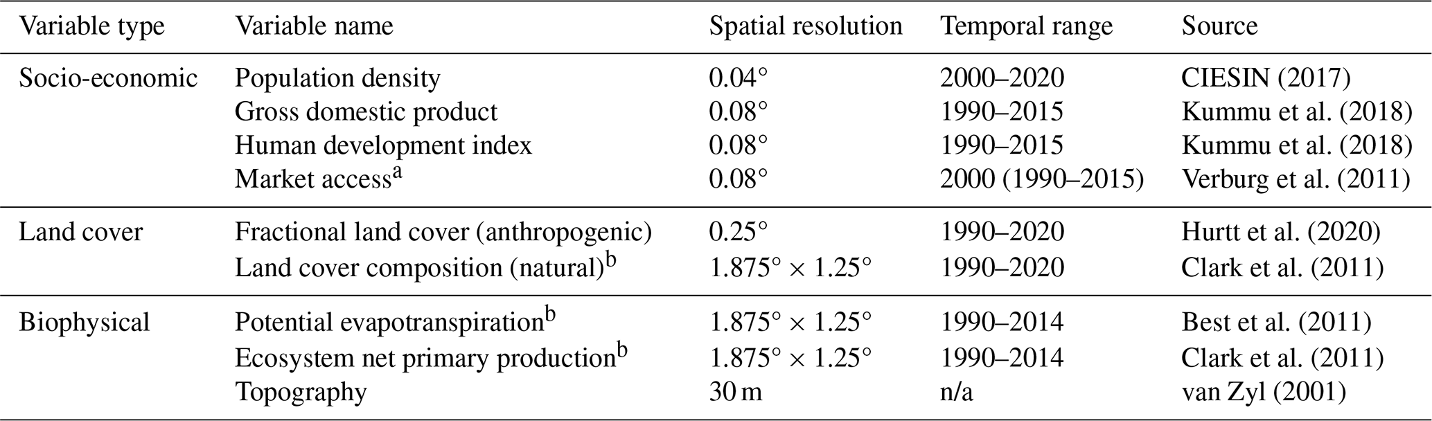
a Single year of data extrapolated to other years from other secondary data (see Perkins et al., 2022, Supplementary material A). b Replaced with Earth observation data in WHAM_EO (Sect. S1 to this paper). n/a: not applicable.
Firstly, to capture the socio-ecological niche of AFTs a simple classification tree was constructed quantitatively for each. This was done using data in DAFI as the target variable and explanatory variables from the secondary data sets given in Table 3. Bootstrapping was used to identify the most robust single-tree structure across data sub-samples. The bootstrapping approach also led to multiple possible split threshold values and output probabilities for the selected structure. These were retained to express data uncertainty and to create transitions between output probability spaces (“niches”) in the resulting maps. To prioritise representation of process and to avoid overfitting, the median and modal number of nodes or splits in AFTs' trees is two, and tree structures were accepted only if they had strong land system process rationale (Perkins et al., 2022). The complete set of tree models used for AFT distribution is provided along with model code (Perkins et al., 2023b).
Secondly, having defined a single tree per AFT, a process of competition was simulated by normalising the output probabilities of tree models across relevant AFTs:
where AFTij is the fractional coverage of the ith AFT in the jth cell, and p(AFTij) and ∑p(AFTj) are the probability of the classification tree for the ith AFT and for all AFTs, respectively. Because of the choice of simple tree structures, to avoid very small land fractions continuing to be allocated to inappropriate AFTs – for example shifting cultivation in the USA Corn Belt – output probabilities beneath a threshold parameter θ were set to 0. In this way, the output probabilities of the tree models of the AFTs' niche were in effect interpreted as a “competitiveness score” in a given pixel. A complete set of AFT distributions is provided as Sect. S5.
2.2 Managed anthropogenic fire
Analysis of DAFI revealed seven central modes of global anthropogenic fire use (Millington et al., 2022): crop field preparation, crop residue burning, pasture management, hunting and gathering, pyrome management, vegetation clearance, and arson. For the first five of these fire uses, a common method of parameterisation was adopted (Sect. 2.2.1); however, vegetation clearance (Sect. 2.2.2) and arson (Sect. 2.3.2) required bespoke approaches. We define arson as fire use as a weapon or to cause deliberate property damage (Scott, 1985); therefore it is classed as unmanaged – though intentional – fire use.
2.2.1 Default fire use parameterisation
Fire use for crop field preparation, crop residue burning, pasture management, hunting and gathering, and pyrome management were parameterised similarly. We parameterise each AFT's decisions to use these forms of managed fire in two stages. Firstly, AFTs decide whether to use a given type of fire; this was parameterised using Boolean fire presence or absence data from DAFI. Secondly, we represent the spatial extent of an AFT's use of a given fire type, in locations where they choose to use it; this was parameterised using burned area data from DAFI. Separating a decision to use fire for a given purpose (hereafter “fire use tendency”) from the burned area generated where it is used (hereafter “fire use extent”) enables WHAM! to capture important nuances in human fire use decision-making. For example, DAFI data show that state land managers such as the US Forest Service are typically fire averse and so have a low fire use tendency; however, where they do use fire, for example in protected areas or other sparsely populated regions, they may burn large areas (Millington et al., 2022).
Fire use tendency and fire use extent maps were calculated with a combination of statistical tools: classification and regression trees, generalised linear models (GLMs), and their combination. These tools were chosen for their simplicity, interpretability, and complementarity. As with the distribution of AFTs, they were constructed using data from DAFI. Owing to data sparsity and sampling biases, corrections were needed for some combinations of AFTs and fire use mode. For example, parameterisation of hunter-gatherer fire did not capture the categorical difference between such fire uses in open savannas versus forest ecosystems. Data in DAFI suggest hunter-gatherer fire in grasslands and savannas burns 18.0 % of the land cover on average compared to 6.7 % in forests (Perkins and Millington 2021). Hence a correction was applied to capture this effect. Similarly, a correction was applied to account for differences between human fire use in the context of livestock farming on the “pasture” and “rangeland” land cover classes in LUH2 (Sects. S2, 2.3). These fire-purpose-specific amendments are detailed in Sect. S2. A complete set of AFT parameterisations is provided along with model code, and their evaluation is described in Sect. S3.
In addition to extra parameters required for specific fire use modes and AFTs, two global biases in DAFI data were corrected using top-down constraints on managed fire use. These were a vegetation constraint and a dominant anthropogenic fire regime (AFR) effect. The impact of both constraints on model outputs is described in Sect. S4. The vegetation constraint corrected for the lack of DAFI case studies in deserts and other very arid environments (Perkins et al., 2022). The goal of the constraint was therefore to remove fire from areas where it could not plausibly exist. Hence, rather than use a measure of vegetation density such as FAPAR (as in Knorr et al., 2014), we use bare soil fraction from JULES to capture only the presence or absence of any vegetation. The vegetation constraint was calculated as
where soilt is the bare soil fraction from JULES outputs at time – t; Tsoil is a free parameter determining at what fractional coverage of bare soil in a cell the vegetation constraint should apply; VCt is the vegetation constraint, and and BAt are raw burned area from bottom-up AFT calculations and burned area adjusted for the vegetation constraint. The initial parameter value of Tsoil was the global mean. Given the highly skewed distribution of bare soil fraction in JULES, this removed fire from biophysically implausible locations whilst having limited impact on WHAM! outputs in other regions.
Similarly, the dominant-AFR constraint was needed as DAFI under-sampled places where fire use was absent in more developed contexts (Perkins et al., 2022). From a process perspective, it aimed to capture the impact of imitation in fire management amongst land users (Lopes et al., 2020; Cammelli et al., 2020) and also the impact of legal and other social barriers that prevent or restrict managed fire use where fire suppression has become the dominant management paradigm (Kreuter et al., 2008; Harr et al., 2014; Bendel et al., 2020). As such, it aimed to capture the social tipping point at which a fire exclusionary attitude (the industrial AFR) became the dominant management approach. The dominant AFR constraint was therefore applied in model cells where the intensive AFR occupied more than half of a cell. It was calculated as
where Industrialt is the fractional coverage of the industrial AFR at time – t; TAFR is a free parameter determining at what fractional coverage the constraint should apply, and AFRCt is the industrial AFR constraint. As a result of this process, the model gained two free parameters: the two critical thresholds at which the bare soil and dominant AFR constraints take effect. The sensitivity of model outputs to WHAM!'s free parameters is explored in Sect. S4.
Table 4Ratio of burned area to total area of vegetation cleared used to parameterise vegetation clearance fire use. A ratio of 1.00 means 100 % of vegetation was cleared by fire use.
n/a: not applicable
2.2.2 Vegetation clearance
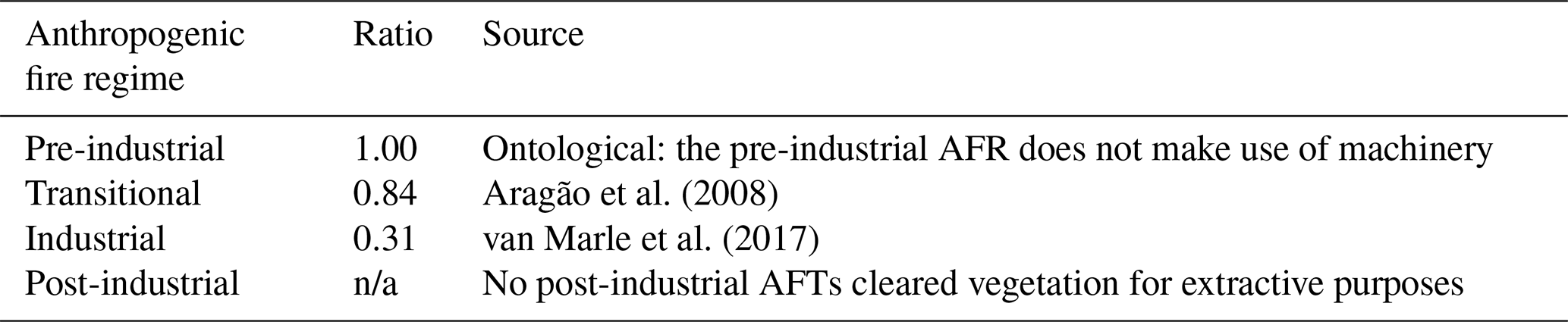
Parameterisation of fire for clearance of primary vegetation (e.g. “deforestation fire”) was complicated by the fact that WHAM! takes land cover inputs from LUH2 (Hurtt et al., 2020). Therefore, rather than seeking to model change in land cover directly, WHAM! instead uses the vegetation-transition-specified LUH2 data (Ma et al., 2020). Using these pre-defined land cover changes between simulated time steps, WHAM! calculates the portion of newly cleared primary vegetation occupied by each anthropogenic fire regime and, on this basis, calculates the fraction of the cleared land area that would have involved fire use. WHAM! uses AFRs rather than AFTs for this calculation to ensure robust data samples.
Further, given that it is frequently a clandestine process, vegetation clearance fire proved highly difficult to quantify in DAFI. Remote sensing data are widely available for the size of cleared patches due to deforestation (e.g. Morton et al., 2006) but not for the specific amount of deforestation driven by differing actors and its relationship to fire. Consequently, DAFI contains 136 measurements of vegetation clearance fire size but only 20 of burned area (Perkins and Millington, 2021). We therefore parameterise the ratio of area of vegetation cleared to burned area for each AFR as free parameters; given the inherent resulting uncertainty, their impact on burned area is explored in model sensitivity analysis (Sect. S4). Initial values for these fire to deforestation ratios are given in Table 4. The ratio between fire and deforestation was assumed to be 1 for the pre-industrial AFR, as by definition this AFR does not use machinery for land management (Millington et al., 2022). Furthermore, none of the AFTs for the post-industrial AFR would clear primary vegetation for extractive land use systems, so there is no ratio for these AFTs.
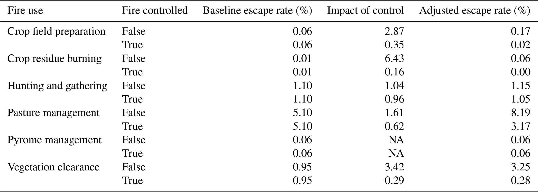
Table 5Parameterisation of escaped fire from Eqs. (6) and (7). Baseline rates of fire escape were calculated from data in DAFI (Millington et al., 2022). The spatiotemporal distribution of the presence of fire control measures was modelled using simple classification tree models (Sect. S2). Pyrome management was assumed to be controlled in all cases. Aside from pyrome management, managed pasture fires are larger (mean = 33.9 ha) than other uses (mean ≤9.2 ha); hence, the pasture fires' more frequent escape rate is offset by a lower density per unit area burned.
2.3 Unmanaged anthropogenic fire
2.3.1 Escaped fires
Escaped fires are those managed anthropogenic fires that escape control measures and grow to become unmanaged wildfires. As with managed fire use, escaped fire parameterisations were derived from data in DAFI. The starting point was the calculation of a baseline escape rate for the six managed fire types described in Sect. 2.2 (Millington et al., 2022; Table 5). This was then adjusted for the degree of fire control measures applied by an AFT. DAFI represents the degree of control measures applied during managed fire use on a 0–3 ordinal scale. There was a clear divide in outcome between no or little control (i.e. 0 or 1) and moderate or intensive fire control (i.e. 2 or 3; Table 5) So, the 0–3 ordinal scale for fire control was reduced down to a Boolean scale: 0–1 were grouped as no substantive attempt to control and 2–3 grouped as a substantive attempt to control.
The result is, in effect, a variable reflecting a meaningful attempt to control a given fire, which was used to calculate the ratio of escaped fires with control measures to those without. The rate of escaped fire for each fire use type and fire control present/absent was calculated as
where ρ is the global mean rate of escape for each fire type, is the number of DAFI records for fire use i, which describe escaped fire, and controli is a Bernoulli random variable representing the probability of the presence or absence of fire control measures.
The next step was to develop a distribution model of the control variable (Eqs. 6 and 7). This was done with simple classification trees. Regimes of fire governance, management philosophy, and their associated degree of fire control measures emerge through complex interactions of land users with their local socio-ecological circumstances and policy at multiple spatial scales (Gil-Romera et al., 2011; Seijo et al., 2015; Mistry et al., 2016). Therefore, rather than parameterising for individual AFTs, the modelled distributions of anthropogenic fire regimes (AFRs) in WHAM! were used as predictor variables, representing the complex landscape-level meta-effects of interactions of multiple actors. Pyrome management was overwhelmingly used with control measures ( cases in DAFI), and so data on uncontrolled pyrome management fire were too sparse to detect the impact of control measures on escape rate. Therefore, as a simplifying assumption, all pyrome management fires were assumed to be controlled.
2.3.2 Arson
Arson was defined as fire used deliberately to harm persons or damage property. Fires caused through carelessness such as untended campfires or cigarettes dropped from car windows were categorised as background or accidental fires (Sect. 2.3.3). As arson fires are lit to cause damage, they are typically not managed and cannot be considered to have an intended burned area in the same way as a pasture or crop residue fire. Therefore, rather than using burned fraction as the dependent variable in the burned area calculation, fires was used.
Furthermore, similar to escaped fire, arson is frequently associated with landscape-level effects, particularly conflict between land users over tenure (e.g. Suyanto, 2007). Therefore, the modelled distributions of AFRs, rather than secondary data, were used as predictor variables. As unoccupied areas were not included in the calculation of AFRs, the impact of very inaccessible terrain such as deserts, the arctic tundra, and rainforests with associated very low populations (i.e. where there are very few humans to use fire as a weapon) was accounted for through a simple linear correction:
where is the output of the arson distribution model, Unoccupied is the fraction of the cell unoccupied by humans, and Arsonadjusted the final calculation of the number of arson fires – adjusted for areas without human occupation.
2.3.3 Background fires
Background fires comprise accidental or incidental fires not captured in managed, escaped, or arson fires. These include unintentional fires caused by, for example, sparks from cigarettes, forestry machinery, and from faulty power lines and other anthropogenic infrastructure (Brennan and Keeley, 2017; Sizov et al., 2021; Bandara et al., 2023; Jenkins et al., 2023). It also includes mismanaged domestic fires and escaped waste disposal fires in urban areas (e.g. Langer and McGee, 2017), as WHAM! does not explicitly parameterise the behaviour of urban residents (who are assumed to occupy land but not manage it in a way that influences landscape fire). Fire density data (fires ) were selected from DAFI where the recorded fire purpose was accidental or unknown. Using these data as a dependent variable, a simple regression tree was then developed.
Table 6Overview of DAFI data used in fire suppression model; unmanaged fires extinguished became the dependent variable in a linear model of the distribution of anthropogenic fire regimes. These initial values will be updated during calibration of the planned coupled model with JULES-INFERNO.
2.4 Fire suppression
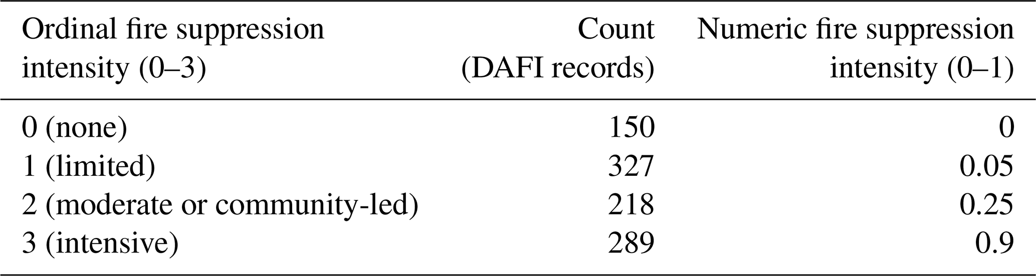
Fire suppression here refers to the extinguishing of active, unmanaged fires. Similar to fire control measures, which are applied by AFTs to constrain the spread of active managed fires, fire suppression emerges from interactions of local land users with policy at multiple spatial scales (Fernandes et al., 2016; Steen-Adams et al., 2017; Bilbao et al., 2019; Eloy et al., 2019b) . As such, the degree of suppression was also treated as a meta-effect, calculated as a function of distribution of the four anthropogenic fire regimes (AFRs) rather than individual AFTs. The AFR distribution calculated by WHAM! became the independent variables in an ordinary least squares regression, the dependent variable of which was the fire suppression indicator in DAFI. Fire suppression was recorded in DAFI on a 0–3 ordinal scale: 0 = none, 1 = limited, 2 = moderate or traditional, and 3 = intensive. To convert this to a numeric value, these ordinal values were given values (Table 6), creating a dimensionless suppression intensity (0–1). The simplest interpretation of this index, and the current impact of suppression intensity in JULES-INFERNO, is that it represents a linear reduction in numbers of unmanaged fires due to active fire extinguishing. However, the exact functional form of the relationship between suppression intensity and reduction in numbers of fires will ultimately depend on the structure of a DGVM during model coupling.
2.5 Model setup for historical runs
To assess and understand the model's outputs and behaviour, WHAM! was run for a historical period from 1990–2014. The rationale of this time frame was driven by data availability. DAFI focused on 1990–2020, whilst 2014 represented the end of the CMIP6 historical run period. As noted in Sect. 2.1, parameters of sub-models for LFS and AFT competition for land have numerical distributions derived from bootstrapping. Therefore, in model runs, 100 samples were drawn from these distributions and the mean value taken. As these distributions form a core part of the model ontology (capturing the transition zones between the niches of different land use systems), they are not a full representation of model uncertainty per se. As such, results presented below focus on the mean values of outputs of these 100 runs.
A baseline run used model inputs that took their historical values. To understand the rationale behind WHAM! outputs for managed fire, two counterfactual experiments were run and compared with the baseline run:
-
LC90 (land cover 90), in which land cover was held constant at 1990 levels, and
-
SE90 (socio-economic 90), in which socio-economic forcing data (GDP, HDI, market access and population) were held constant at 1990 values.
As primarily an empirical model, WHAM! has only six free parameters; a model sensitivity analysis was conducted to fit these parameters, as described in Sect. S4.
2.5.1 Model evaluation
Calculating burned area from unmanaged fires projected by WHAM! requires coupling with a biophysical model. As such, whilst all WHAM! outputs are presented (as per Table 1), prior to the planned coupling with JULES-INFERNO evaluation of model outputs focuses on managed fire only. Crop residue burning outputs are the easiest to evaluate, as these can be compared directly with the GFED5 crop fire product (Hall et al., 2024). Similar to the first FireMIP (which used the GFED4 and 4.1s products), this comparison was done using data for the overlapping period of WHAM! historical runs and the MODIS-era of GFED5 (2001–2014; Rabin et al., 2017). As in Teckentrup et al. (2019) Pearson's correlation coefficient between WHAM! outputs and GFED5 was calculated using a square-root transformation to account for the skewed distribution of burned area. To account for differences in underlying cropland distributions that are inputs to GFED5 (the MODIS-derived MCD12Q1; Hall et al., 2024) and WHAM! (LUH2; Hurtt et al., 2020), correlations were also calculated for the proportion of cropland burned per pixel.
In addition, a broad assessment of plausibility of WHAM! managed fire outputs was made. The great majority of managed anthropogenic fires are small, and smaller than the 21 ha threshold at which MODIS can reliably detect burned area (Andela et al., 2019; Millington et al., 2022). However, in GFED5, MODIS is cross-referenced against fine-scale remote sensing data from Landsat (30 m2) and Sentinel-2 (20 m2), and hence small fires are beginning to be incorporated in global-scale Earth observation. As such, between 2001–2014, GFED5 has a mean burned area 457.7 Mha greater than GFED4 (800.3 Mha vs. 342.6 Mha, respectively, Giglio et al., 2013; Chen et al., 2023). Of course, not all of this difference is necessarily due to anthropogenic fires (van Wees et al., 2022), but comparison of the GFED4 to GFED5 increase and WHAM! managed fire outputs offers a high-level assessment of their plausibility.
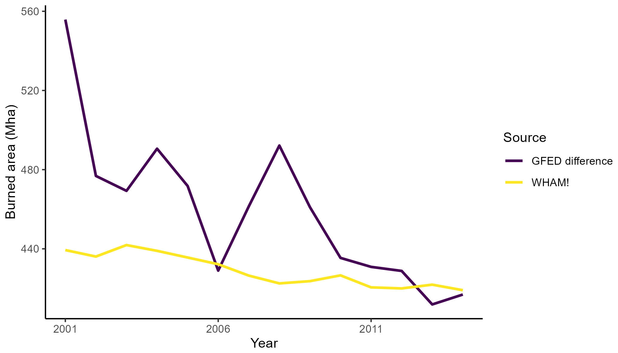
Figure 3Total WHAM! managed fire compared against the difference in burned area in GFED5 and GFED4. Whilst the increase in burned area detected by GFED5 over that detected in GFED4 is primarily due improved detection of small fires, not all of these will be managed anthropogenic fires. As such, this comparison is offered not as a like-for-like evaluation but to establish the broad plausibility of WHAM! outputs.
Furthermore, evaluation of the sub-models for managed and unmanaged fire and fire suppression was conducted in three ways. Firstly, within-sample performance of managed and unmanaged fire parameterisations is assessed using r2 for regression and AUC (area under the received operated curve) for classification. Secondly, these parameterisations are compared against out-of-sample (unseen) DAFI data. These are available due to the fragmented nature of data on human–fire interactions. For example, if the dependent variable of a fire use parameterisation was the percentage of a land cover burned, then data from DAFI case studies reporting fire return interval (but not % burned area) could be used as unseen evaluation data. Thirdly, the temporal trend in WHAM! outputs was evaluated by comparison with the qualitative evaluation of temporal trend in the Livelihood Fire Database (LIFE; Smith et al., 2022). LIFE provides assessments of whether “subsistence-oriented” and “market-oriented” fire use were declining, stable, or increasing in the human–fire use literature. The details and outcomes of these evaluation steps using DAFI and LIFE case study data are reported in Sect. S3.
3.1 Model evaluation
Burned area from WHAM! managed fire has a coherent relationship with the difference between GFED5 and GFED4 outputs. From 2001–2014 (the overlapping period of WHAM! and the MODIS-era of GFED), the mean difference between GFED5 and GFED4 is 459.4 Mha, compared to burned area in WHAM! of 428.9 Mha (Fig. 3). Pearson's correlation coefficient between WHAM! and GFED4–GFED5 difference (r = 0.70) is greater than the mean of the model ensemble in the first FireMIP (r = 0.65; Teckentrup et al., 2019) indicative of good performance for a first-in-class model. As noted above, comparison of WHAM! to the GFED5 to GFED4 difference is not a direct comparison of managed fire but is provided as an initial assessment of WHAM! output plausibility.
Figure 4Comparison of WHAM! crop residue burning outputs and GFED5 crop fire outputs in 2014. Whilst overall coherence is good, disagreements are most evident in northern India.
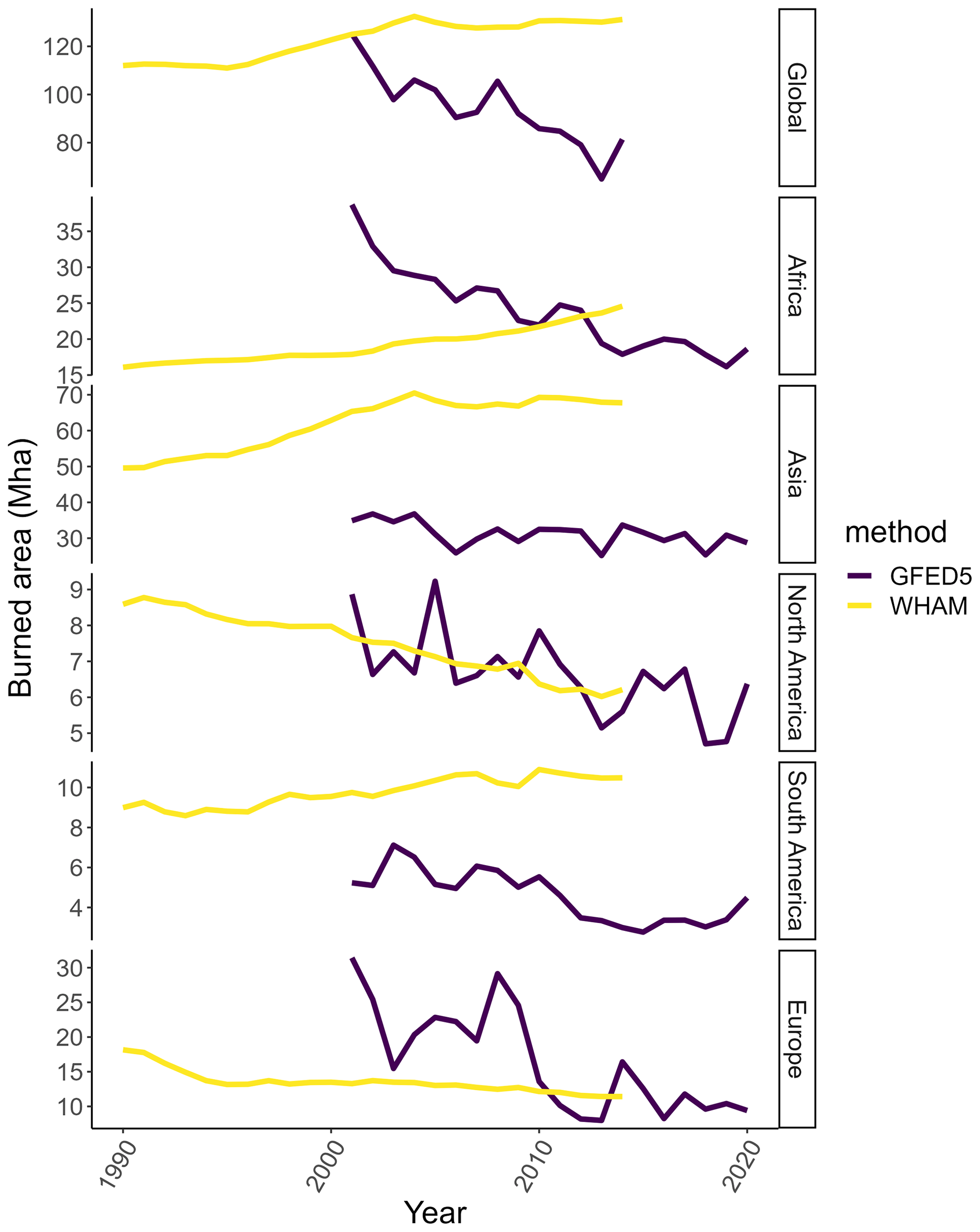
Figure 5Continent-scale trends in burned area for WHAM! crop residue fires and GFED5 crop fires. The biggest area of disagreement in burned area is in Asia. Conversely, whilst in Africa burned area is similar, WHAM! and GFED5 show opposite temporal trends. Note the differing y-axis values.
WHAM! outputs for crop residue burning are in broad agreement with GFED5 crop fires (Fig. 4). Correlation (Pearson's r) is 0.673 for burned area per pixel and 0.665 for rate of cropland burned per pixel. WHAM! crop residue outputs project more burning than GFED5, with an annual mean of 129.2 Mha over the overlapping period (2001–2014) compared to 87.6 Mha for GFED5. The main continent driving disagreement is Asia: 67.8 Mha in WHAM! compared to 31.2 Mha in GFED5 (Fig. 5).
WHAM! and GFED5 disagree on the trend of global crop fires, with WHAM! projecting a global increase and GFED5 suggesting a decrease (Fig. 5). At the continental scale, WHAM! and GFED5 agree on the trends in Europe and North America (decreasing). However, WHAM! projects gains in Asia (GFED decreasing), as well as increases in Africa (GFED decreasing). It is notable that WHAM! exhibits contrasting trends between crop residue fires and other managed fires. For example, in South America and Asia, WHAM! residue fires and other managed fires are negatively correlated (r = −0.91, −0.74, respectively), whilst GFED5 outputs for crop fires and the overall regime are positively correlated in all cases.
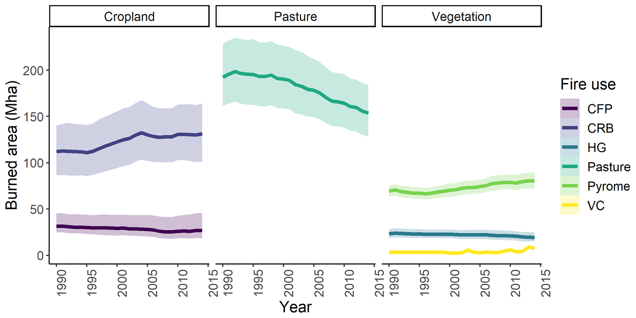
Figure 6Temporal trends in managed fire. Lines show the global mean, shading the 5th and 95th percentiles of the outputs from WHAM! parameters' numerical distributions. Overall, pasture fire accounts for both the largest amount of fire and the largest absolute decline. In cropland systems, shifting cultivation fire and residue burning exhibit opposite trends. Whilst vegetation clearance fire is small in absolute terms, it shows the largest relative increase over the model period. Key: CFP – crop field preparation, CRB – crop residue burning, HG – hunter-gatherer, Pasture – pasture management, Pyrome – pyrome management, VC – vegetation clearance.
3.2 Analysis of model outputs
3.2.1 Managed fire
Over the study period of 1990–2014, modelled burned area from managed anthropogenic fires decreases from 431.9 to 419.1 Mha. In percentage terms, this equates to a 3 % decline. There is substantial heterogeneity in the trend amongst fire use types. The overall modelled decline in burned area is primarily due to a decrease in fire for pasture management, which declines 20.1 % from 192.04 to 153.7 Mha over 1990–2014 (Fig. 6). This is complemented by declines in shifting cultivation (crop field preparation) fire (31.5 to 26.9 Mha) and hunter-gatherer fire (23.2 to 19.4 Mha). By contrast, crop residue burning increases by 17.0 % from 112.0 to 131.1 Mha, and pyrome management fire use increases by 15.7 % from 69.5 to 80.4 Mha. In absolute terms, vegetation clearance fires burn the smallest area (3.4–9.1 Mha), but in relative terms, their increase is much the largest (217 %), highlighting this growing environmental challenge.
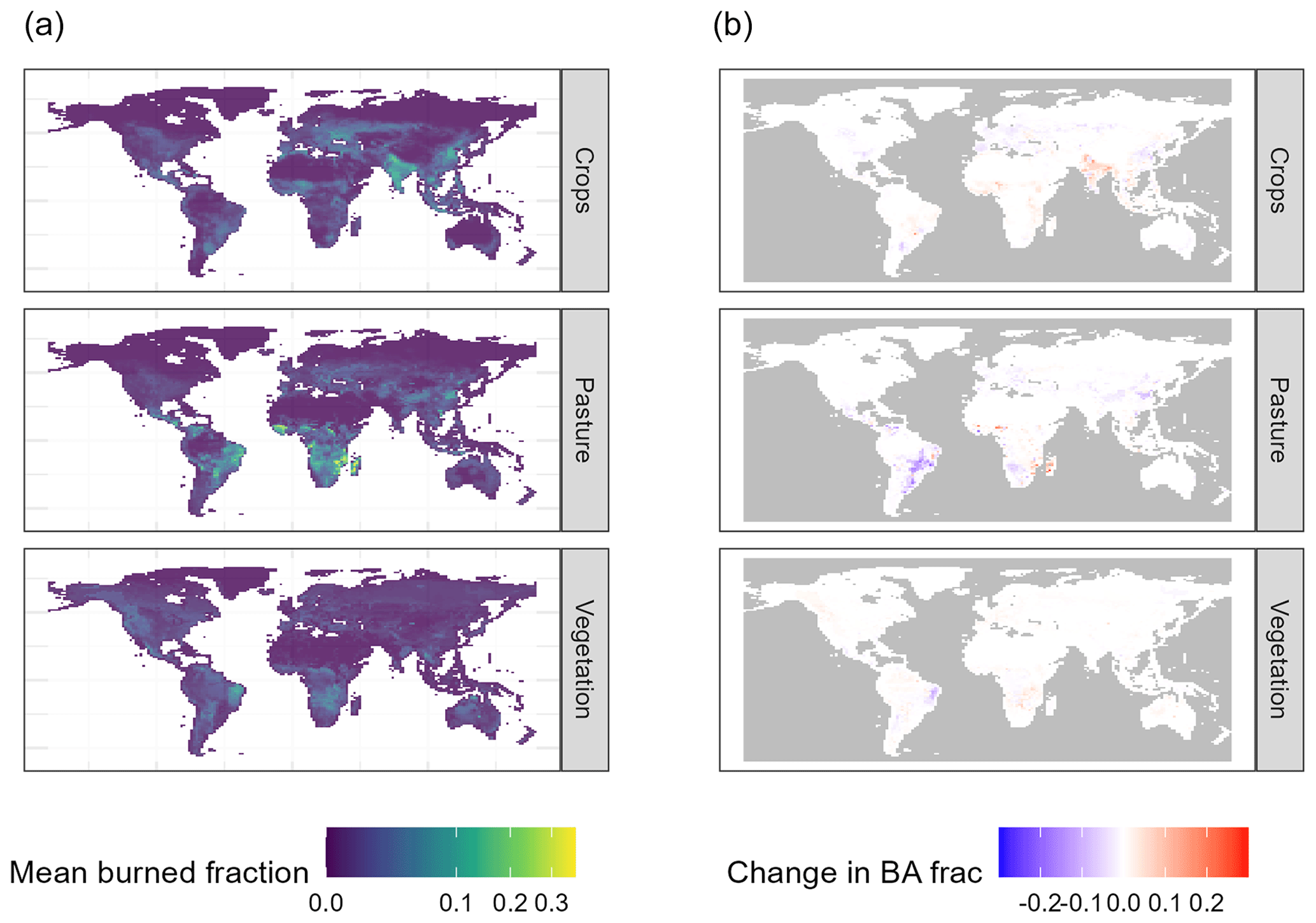
Figure 7Global model outputs for managed fire grouped by land cover. (a) Mean values across 1990–2014 and (b) change in burned area fraction between 1990 and 2014. Forestry and non-extractive fire use types are grouped together as this will be how they are interpreted by JULES-INFERNO. Maps highlight the decline in pasture fires in South America. Conversely, pasture fire increases in sub-Saharan Africa. Crop fires increase in northern India, South Asia, and modestly in South America but decline elsewhere. Vegetation fires cover those for hunting and gathering, pyrome management, and vegetation clearance.
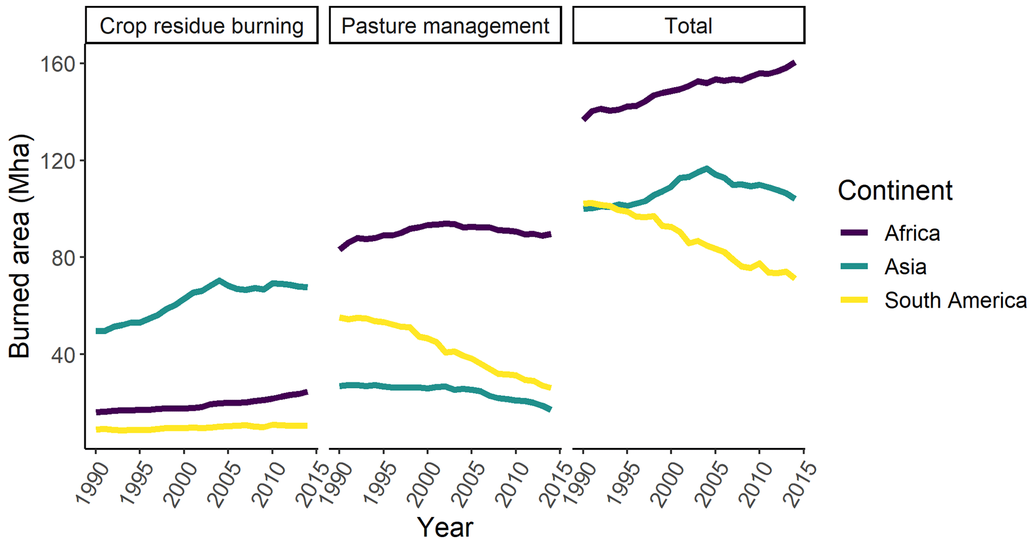
Figure 8Managed fire burned area for the two dominant modes of managed fire and total managed fire for the three continents with largest burned area from managed fire. Whilst the global declining trend in pasture management fire is dominant in South America, in Africa pasture and crop residue fires contribute to an overall slight increase. Similarly, in Asia a decline in pasture fire is offset by a marked increase in crop residue fires.
Beneath the global trends in managed fire, there is also substantial spatial heterogeneity (Fig. 7). At the continental scale, the decline in pasture management fire dominates in South America, declining from 55.31 Mha in 1990 to 25.15 Mha in 2014, leading to a decline in overall managed fire from 102.14 to 71.12 Mha (Fig. 8). By contrast, in Africa pasture fire increases by 6.51 Mha, whilst in Asia a decrease in pasture fire of 9.83 Mha is more than offset by a steep increase in crop residue burning of 18.17 Mha.
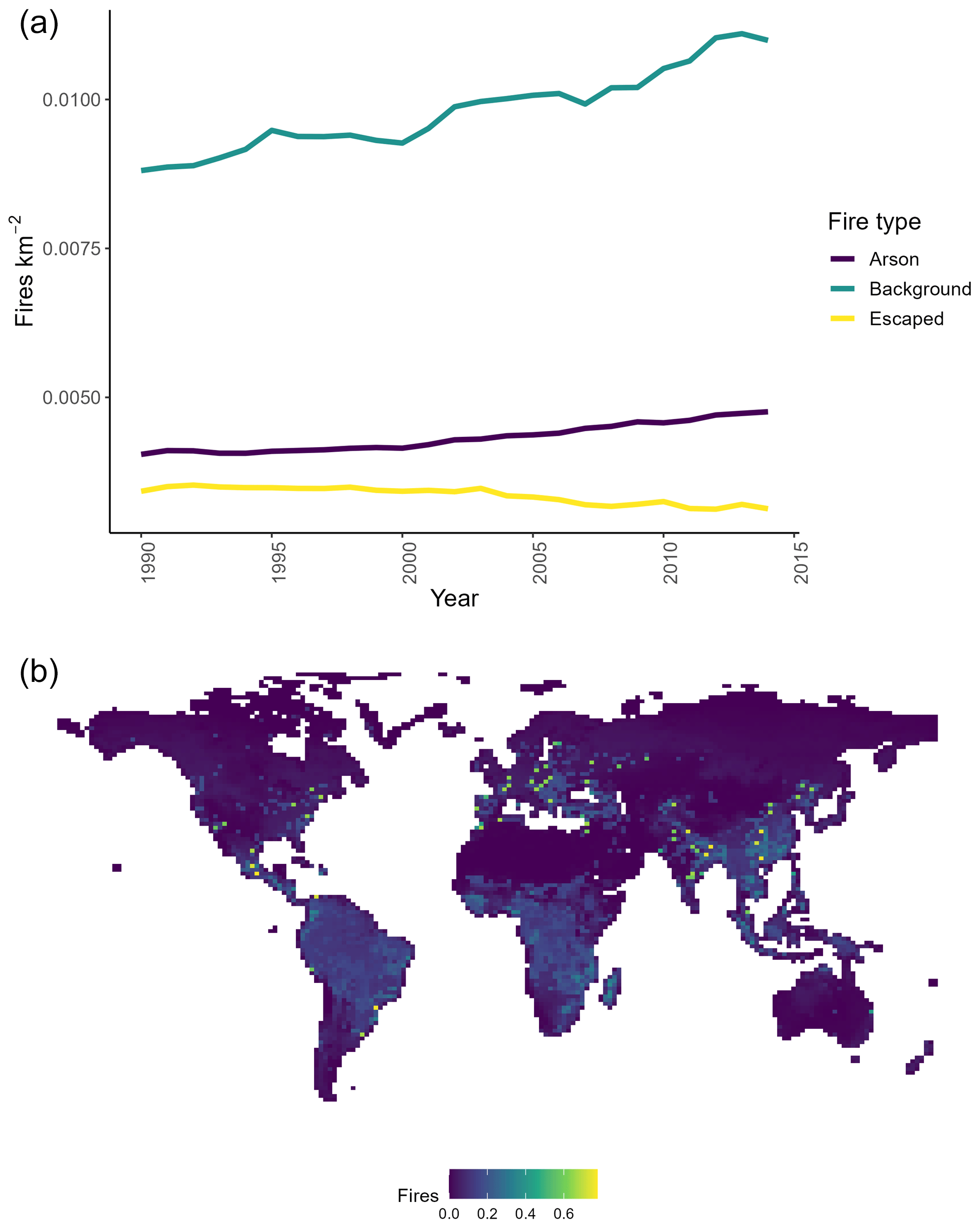
Figure 9Unmanaged fire outputs as fires : (a) temporal change and (b) spatial distribution in 2014. The rate of unmanaged fires increases over the modelled period. However, this increase is clustered towards areas at the periphery of cities, as measured by market access (visible as spatial anomalies in b). The impact of this pattern of numbers of unmanaged fires on burned area will only be clear after coupling with JULES-INFERNO.
3.2.2 Unmanaged fire
Whilst burned area from managed fire modestly decreases by 3 % globally, the picture from unmanaged fire is mixed. Arson and accidental anthropogenic fires both increase (Fig. 9): the background rate of accidental fires increases 24.8 %, whilst the rate of arson increases 17.7 %. By contrast, the number of escaped fires decreases (−8.6 %), mirroring the decrease in burned area from managed fire. However, until WHAM! is coupled with a DGVM, it will not be possible to deduce if this has led to increase in burned area from unmanaged anthropogenic fire. This consideration is particularly important given the distribution of unmanaged fires is clustered in urbanised areas (Fig. 9b), meaning that many of these ignitions will likely be extinguished through industrialised fire-fighting (Millington et al., 2022).
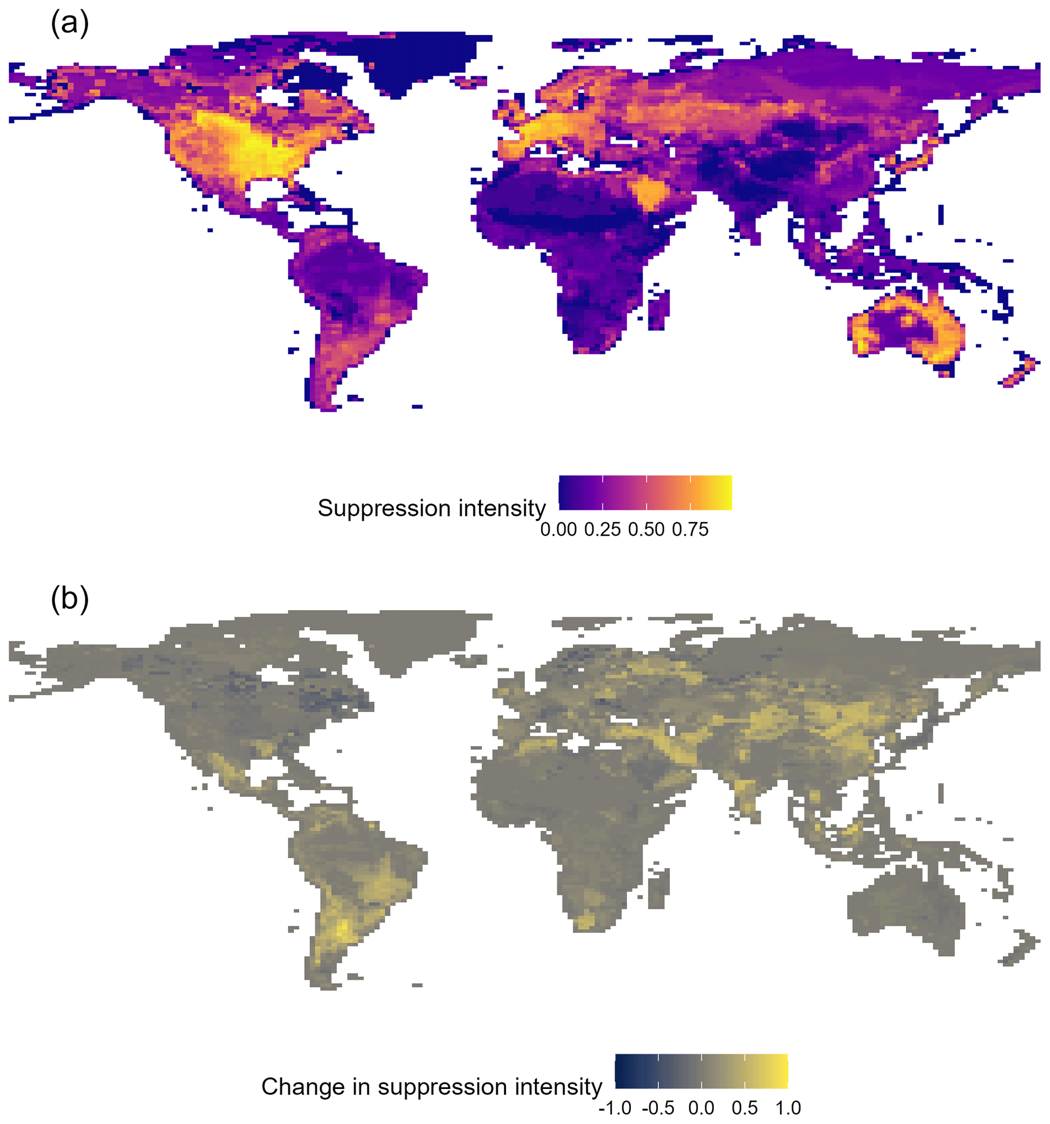
Figure 10Fire suppression intensity. (a) Mean suppression intensity across 1990–2014. (b) Change in suppression intensity between 1990–2014. Reductions in suppression intensity in Canada, Scandinavia, and elsewhere reflect land abandonment and rural depopulation.
3.2.3 Fire suppression
Overall, modelled fire suppression increases from 1990–2014, particularly in South America, South Asia, and South-East Asia (Fig. 10). As noted above, outputs here are a dimensionless suppression intensity (0–1). The form of the relationship of suppression intensity to reduction in the number of unmanaged fires will be determined through the planned coupling with JULES-INFERNO.
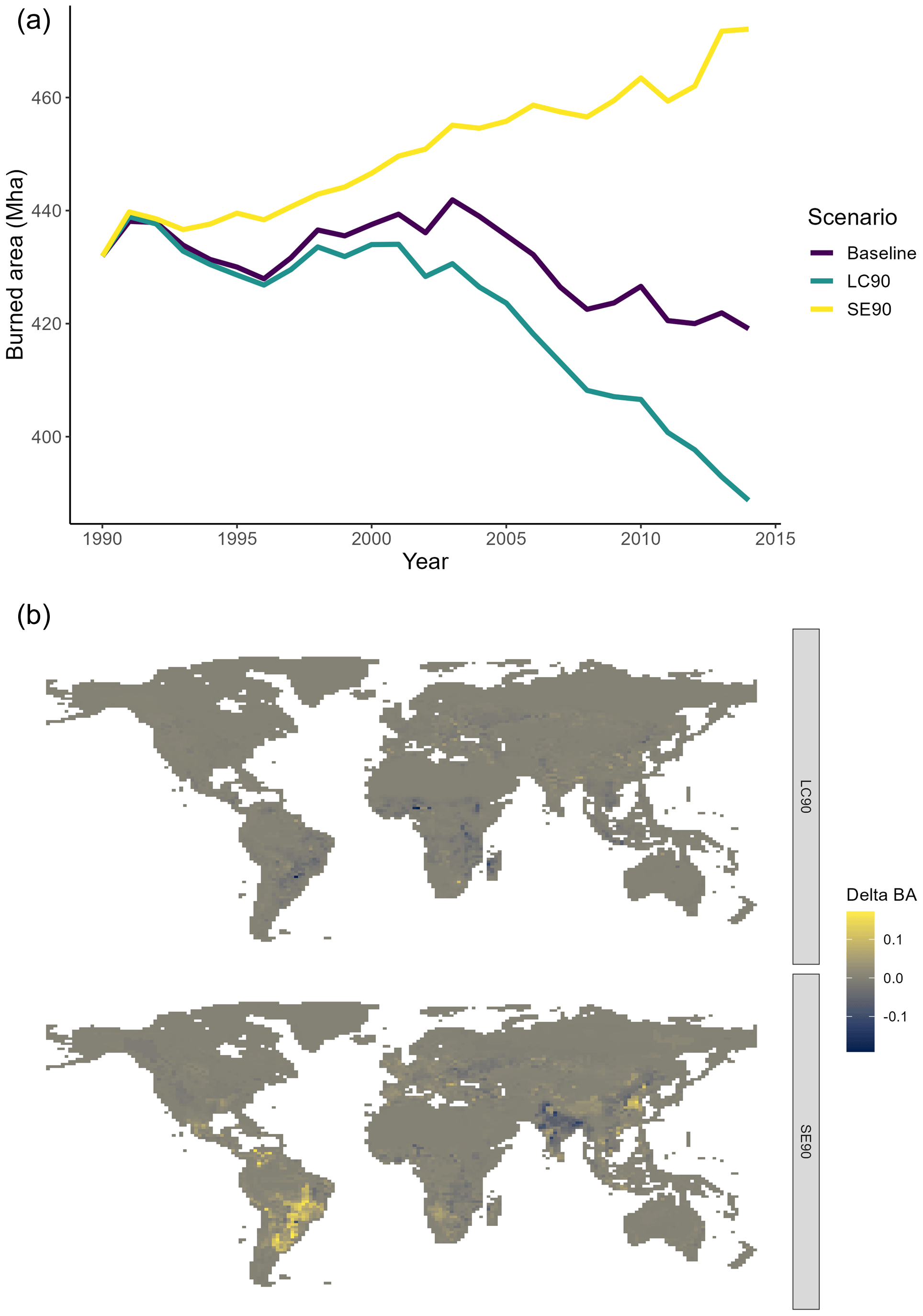
Figure 11Global burned area from managed fire under counterfactual scenarios. (a) Global trends 1990–2014; (b) difference in burned area between counterfactual and baseline scenario in 2014. Key: LC90 – land cover held constant at 1990 levels; SE90 – socio-economic forcing held constant at 1990 levels.
3.3 Understanding model behaviour
Counterfactual experiments reveal divergent impacts between land cover change and changes in socio-economic forcings. In the LC90 experiment, where land cover was held constant at 1990 levels, managed fire declines more starkly than in the baseline model run (431.94 to 388.74 Mha; Fig. 11). By contrast, SE90 (socio-economics held constant at 1990 levels) leads to an increase in overall managed fire from 431.94 to 472.10 Mha.
The effects of land cover and socioeconomic forcings on human fire use have clear spatial patterns (Fig. 11b). In SE90, the increase in fire over the baseline scenario is most evident in South America, highlighting the importance of socioeconomic development, and consequent land use intensification in this continent as a driver of changing fire regimes (Ribiero et al., 2024). Similar increases over the baseline are present in north-eastern China and Mexico. By contrast, in northern India, the SE90 counterfactual leads to decreased fire against the baseline, indicating land use intensification has led to increased fire use. This finding fits previous analyses of crop residue burning in the Indo-Gangetic Plain (Liu et al., 2019; Sembhi et al., 2020). The LC90 (constant land cover) counterfactual has more consistent global effects, with decreases in fire over the baseline observed in regions with large amounts of extensive livestock farming – particularly Madagascar, the Guinean Savanna, and southern Brazil.
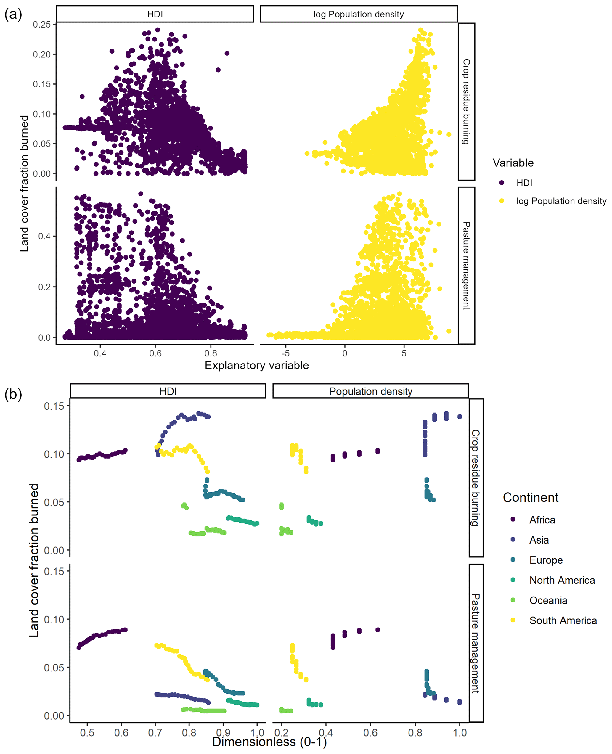
Figure 12Drivers of managed burned area for the two modes of anthropogenic fire use with largest global burned area: (a) mean values across 1990–2014 by pixel and (b) continental mean for each model year. Population density marginally increases the rate of crop residue burning but has an unclear impact on pasture management. Similarly, the human development index (HDI) has a complex relationship with fire use: increasing HDI is associated with increased pasture management fire in Africa, but increasing HDI elsewhere is associated with declining pasture fire. The relationship between HDI and crop residue burning is also complex, with associations in both directions.
Divergent trends between land use and land cover change on human fire use point to similarly divergent socio-economic drivers across differing modes of fire use (Fig. 12). For example, at global scale, population density seems to be associated with increased crop residue burning (r = 0.42). By contrast, population density has a more ambiguous effect on pasture management fires (r = 0.07), the distribution of which has an overall negative correlation with socio-economic development (as measured by the HDI; r = −0.31). However, in lower HDI regions (<0.65; Fig. 12b), increasing HDI seems to be associated with increased pasture management fire.
Similarly, across the three continents with the highest rates of agricultural fire – Africa, Asia, and South America – increased HDI consistently leads to decreased fire use for pasture management (Fig. 12b). However, in these three continents, increased HDI can lead to either increased or decreased fire use for crop residue burning: at a mean HDI of ∼ 0.7 such fire use increases substantially in Asia but decreases in South America. Possible process-based explanations of this trend are offered in the discussion (Sect. 4.1).
We have presented WHAM!, the first global behavioural land system model of human fire. The ultimate intention is to couple WHAM! with the JULES-INFERNO DGVM. Here, WHAM! has been presented in standalone form. Therefore, the discussion focuses on managed fire, which can be independently evaluated without input from JULES-INFERNO.
4.1 WHAM! outputs
WHAM! outputs suggest burned area from managed anthropogenic fire declined by 12.8 Mha from 1990 to 2014. This is driven by decreased fire use for pasture management particularly in South America (Fig. 8) and complemented by declines in crop field preparation (shifting cultivation) and hunting and gathering fire. By contrast, fires for crop residue disposal increased by 19.1 Mha. These divergent trends broadly align with Smith et al. (2022), whose global meta-analysis found that “subsistence-oriented” fire uses are declining, whilst “market-oriented” fire uses are increasing (Sect. S3). Globally, empirical data show cropland fire uses produce the smallest anthropogenic fires (mean = 3.9 ha; Millington et al., 2022). Therefore, outputs from WHAM! are also consistent with initial results from the Global Fire Emissions Database version 5 (GFED5), which suggest smaller fires – which are principally anthropogenic – have declined less than larger ones (Chen et al., 2023). Taken together, these recent advances spanning literature meta-analysis, remote sensing, and now modelling suggest changes in anthropogenic fire use are contributing to the observed global decline in burned area but perhaps at a lower rate than changes in burned area from unmanaged wildfires (Andela et al., 2017).
Counterfactual experiments and analysis of the drivers of pasture management fire in WHAM! demonstrate that the modelled decline in pasture fire is primarily due to economic development and associated land use intensification (Fig. 11). This finding matches real-world observations. For example, the rapid pace of land use intensification in South America was documented by Silva et al. (2017), who attribute changes to the “telecoupled” system of soybean production in response to increased demand for meat. Furthermore, this process of declining fire under increased land use intensity was explored in the field experiments of Cammelli et al. (2020), who find that increased capital investment discourages fire use as a management strategy because fire increasingly becomes a risk to machinery, irrigation, and other capital investments.
By contrast, the relationship between increasing societal development (represented by the human development index) and crop residue burning is more ambiguous (Fig. 12). In Africa (HDI: 0.45–0.65), increased HDI seems to increase crop residue burning, consistent with land use intensification driving this practice. However, at intermediate (0.6–0.85) levels of HDI, increased development can have divergent impacts on residue burning, notably between Asia and South America. It is possible that farm size, and therefore the production system, plays a role here: large soybean farmers in South America engaged in formal, legalised supply chains are somewhat likely to comply with anti-burning as well as general fire management legislation (Soares-Filho et al., 2014; Villoria et al., 2022). By contrast, in Asia, and the Indo-Gangetic Plain in particular, high rural population density and small average farm size entails that production is dominated by small-holder farms with associated informal supply chains (Birthal et al., 2017), making environmental enforcement more challenging (Bhuvaneshwari et al., 2019; Liverpool-Tasie et al., 2020). In WHAM!, this difference is seemingly captured through the impact of population density, which features in the classification tree for the small-holder land fire system (Perkins et al., 2022).
WHAM! suggests human fire use can either increase or decrease with increasing population, in ways that are highly heterogenous and specific to the rationale of the underlying land system and associated modes of fire use (Fig. 12). At global scale, crop residue burning slightly increases with population density, but there is a weak negative relationship with pasture fire. Taken together, these complexities illustrate the shortcomings of relying on a single function of population density to capture the full spectrum of human–fire interactions globally (Teckentrup et al., 2019) and the benefit of taking a categorical approach to developing functions for representing human activity.
Therefore, whilst WHAM! is, at root, a relatively simple empirical model, it captures complex dynamics amongst the drivers and spatiotemporal distribution of human–fire interactions. This is further highlighted by the use of anthropogenic fire regimes (AFRs) to capture emergent or landscape-level effects. For example, arson fires become 17.7 % more frequent over the period 1990–2014, driven by WHAM!'s representation of land tenure conflict through the transitional AFR. By contrast, the number of escaped managed fires declines (−8.6 %). Using the AFRs as predictor variables in parameterisations of arson and fire control behaviours (which have an important influence on escaped fire) results in high predictive accuracy (AUC ≥ 0.8; Sect. S3). As such, we can conclude that use of the AFRs allows differing trends in sources of unmanaged fires to be identified (Fig. 9), further highlighting the shortcoming of relating to anthropogenic fire directly to population density without considering the global diversity of human–fire interactions.
4.2 WHAM! evaluation and limitations
Comparison with GFED5 cropland fires suggests WHAM! credibly reproduces global patterns of crop burning. However, there are some disagreements between WHAM! and GFED5 crop fires, notably in terms of the spatial distribution of such fires in India and the temporal trend in sub-Saharan Africa. Evaluating the distribution of the land fire systems in WHAM!, Perkins et al. (2022) find that the crop fire hotspots in northern India and in northeastern China were also spots of disagreement between WHAM!'s distribution of land fire systems and the human appropriation of net primary production – an independent measure of land use intensity (Haberl et al., 2007). As such, this difference may point to underlying difficulties in representing land use transitions through a single transitional fire regime type per land system, when in reality multiple trajectories of intensification (and de-intensification) can occur, even within apparently similar land system types (Lambin and Meyfroidt, 2010; van der Sluis et al., 2016).
However, it is important to note that the GFED5 cropland product is the first of its kind – and is itself a model relying on empirical scaling factors to infer burned area per active fire detection in cropland areas (Hall et al., 2024). These scaling factors for rice burning were developed from fieldwork in Ukraine (Hall et al., 2021), where the mean field size of 40 ha is much larger than the smallholder fields in northern India (∼ 1 ha). Hence, a single active fire detection in northern India could very possibly equate to more real-world burned area than in Ukraine, indeed as is suggested by the work of Deshpande et al. (2022). Increased spatial coverage of ground-truthed, landscape-level remote sensing work of cropland burning is needed to advance understanding further.
As with any empirical model, WHAM! is inherently limited by the strengths and weaknesses of its underlying data. There were three central ways in which such uncertainties in the Database of Anthropogenic Fire Impacts (DAFI, against which WHAM! was parameterised) came through in model outputs, which are discussed in turn below. The first of these was in the parameterisation of fire use in nomadic land use systems, particularly shifting cultivation and pastoralism. The mediocre performance of the underlying models is indicative of the difficulty of quantifying fire regimes produced by such land use systems (AUC = 0.623, r2 = 0.07). For example, shifting cultivation is challenging to study with remote sensing, not only as it is semi-nomadic, but also due to the complex spectral signals produced (Jiang et al., 2022), which make differentiating between fields and early-successional regrowth a substantial challenge (Heinimann et al., 2017). As a result, the fallow period was typically used from field studies as a proxy for fire return period. This involved assumptions about the duration of cultivation after fallow, here assumed to be 2 years – yet this can vary from 1–5 years (e.g. Maharani et al., 2019). Pastoralism is also challenging to study with remote sensing, due to the difficulty of tracking pastoralists' location across the large areas over which they may migrate seasonally (Nelson et al., 2020). However, it should be noted that these fire uses represent a small amount of global burned area: burned area from shifting cultivation was 26.9 Mha, whilst migratory pastoralist fire accounted for just 18.4 Mha of burned area in 2014.
Secondly, more structural sampling biases within DAFI led to the need for top-down constraints being applied to the bottom-up parameterisation of fire uses. These arose firstly as DAFI did not sample very arid environments (the vegetation constraint) and, secondly, because DAFI under-sampled more developed contexts (Perkins et al., 2022). However, sensitivity analysis demonstrated that WHAM! is not overly sensitive to the resulting free parameters – with burned area outputs varying by a maximum of ± 4.4 % (Sect. S4). Furthermore, the most sensitive parameter was not for a top-down constraint but the “theta” parameter, which sets the threshold at which a given AFR's competitiveness score was set to 0 (Sect. S4). This is somewhat analogous to the “giving-in” parameter in the CRAFTY land system model, which determines when a land use type becomes uncompetitive (Murray-Rust et al., 2014). CRAFTY is highly sensitive to this parameter (Seo et al., 2018), which is an uncertain function of agent behaviour. There seems to be a strength of the empirical approach taken here, as it appears less reliant on uncertain abstraction.
A third fundamental issue arises from the coarse spatial resolution of WHAM! and how that relates to the data available for parameterisation. Specifically, due to the intended coupling with JULES-INFERNO, the spatial resolutions of WHAM! and DAFI case study data are substantially different: the median WHAM! cell is 7 times larger than the median DAFI case study (24 684 vs. 3508 km2). However, this is likely a large underestimate of the true discrepancy. Only 30 % of case studies in DAFI reporting pre-industrial AFRs quantified their study area, compared with 82 % of industrial AFR case studies (Perkins and Millington 2021). The mean reported study area for industrial AFR case studies is 53 times larger than for the pre-industrial AFR. This trend is likely even more acute for LIFE (Smith et al. 2022), as it focuses on “livelihood fire” – which broadly corresponds to the pre-industrial and early transitional AFRs in WHAM!. However, case study area is not recorded in LIFE (Smith et al., 2022). The consequence of this disparity in spatial resolution is seen in the evaluation of model outputs against unseen case study data in DAFI and LIFE: WHAM! captures macro-scale trends, but in its first iteration does not fully capture more detailed trends at the case study level (Sect. S3).
In addition to data limitations, this first version of WHAM! has two main structural limitations. The first of these is a lack of seasonality in human fire use. DAFI contains data on the months in which a given fire use practice was present. In principle this information could be extrapolated to create global seasonality maps for each of the managed fire use types. However, such an approach would require an account of how contrasting forms of seasonality (e.g. temperature-based, precipitation-based, or their combination) influence timing of fire use, complexity which is compounded by bimodal patterns of crop residue burning in double-cropping systems (Liu et al., 2019). Future work could explore how to account for such complexities. The second structural limitation in WHAM! is a lack of explicit representation of policy. Representation of policy could, for example, replace the top-down AFR constraint by explicitly capturing the impact of fire-averse and fire-exclusionary policies. DAFI also contains data on policy, which could in principle be used to parameterise representation of government “observer” agents in each country. However, development of such functionality is an ongoing challenge within land system modelling (see discussion in Perkins et al., 2023c), so it will need to be addressed in future versions of WHAM!
This paper has presented WHAM!, the first global behavioural land system model of present-day human–fire interactions. WHAM! is designed to be coupled with dynamic global vegetation models – JULES-INFERNO in the first instance. As such, full evaluation of WHAM! will only be possible once this coupling is complete. However, here we demonstrate that, independently, WHAM! is effective at capturing both spatial and temporal trends in Earth observation data of burned area. Evaluation of WHAM! with GFED5 crop fires reveals strong spatial coherence, whilst WHAM! managed fire outputs project a decline in burned area between 1990–2014, driven by land use intensification and declining fire use for extensive livestock farming. Burned area from managed fire outputs in WHAM! is close to the difference in global Earth observation data with (GFED5) and without (GFED4) small fires, establishing the broad plausibility of model outputs.
Drivers of human fire use in WHAM! are divergent across differing fire use types and spatially heterogenous, pointing to the fundamental limitation of globally uniform population-based approaches, which are widely used in existing global fire models. Additionally, use of landscape-level anthropogenic fire regimes proves an effective way to capture influences that emerge from interactions between land users: this includes fire suppression, the extent of control applied to managed fires, and arson. Overall, the diversity of human–fire interactions and their divergent spatiotemporal trends highlight a fundamental need for consideration of the socio-ecological drivers of fire regimes in dynamic global vegetation models.
All code and data to run WHAM! version 1.0 are made freely available online via Zenodo (https://doi.org/10.5281/zenodo.8319310, Perkins et al., 2023a; https://doi.org/10.5281/zenodo.8319310, Perkins et al., 2023b). This includes an installation and user guide. For convenience, GitHub installation is also available at https://github.com/OliPerkins1987/Wildfire_Human_Agency_Model (last access: 13 May 2024).
The supplement related to this article is available online at: https://doi.org/10.5194/gmd-17-3993-2024-supplement.
All authors contributed to model conceptualisation and methodological design from their contrasting disciplinary perspectives; OP wrote the software, whilst MK ensured model structure supported integration with JULES-INFERNO; OP and CS were responsible for data curation. AV secured funding. JDAM provided project oversight and leadership. OP wrote the original draft, whilst all authors contributed to editing and revisions.
The contact author has declared that none of the authors has any competing interests.
Publisher's note: Copernicus Publications remains neutral with regard to jurisdictional claims made in the text, published maps, institutional affiliations, or any other geographical representation in this paper. While Copernicus Publications makes every effort to include appropriate place names, the final responsibility lies with the authors.
This work was funded by the Leverhulme Centre for Wildfires, Environment and Society through the Leverhulme Trust, grant no. RC-2018-023. The authors wish to thank Davide Lomeo and Toby Wainwright for their kind help with cross-platform compatibility testing and wish to thank Calum Brown, Tamsin Edwards, and Colin Prentice for their helpful comments and suggestions.
This research has been supported by the Leverhulme Trust (grant no. RC-2018-023). Apostolos Voulgarakis has also been supported by the AXA Research Fund (project “AXA Chair in Wildfires and Climate”) and by the Hellenic Foundation for Research and Innovation (grant no. 3453).
This paper was edited by Carlos Sierra and reviewed by Carolina Ojeda Leal and Sam Rabin.
Andela, N., Morton, D. C., Giglio, L., Chen, Y., van der Werf, G. R., Kasibhatla, P. S., DeFries, R. S., Collatz, G. J., Hantson, S., Kloster, S., Bachelet, D., Forrest, M., Lasslop, G., Li, F., Mangeon, S., Melton, J. R., Yue, C., and Randerson, J. T.: A human-driven decline in global burned area, Science, 356, 1356–1362, https://doi.org/10.1126/science.aal4108, 2017.
Andela, N., Morton, D. C., Giglio, L., Paugam, R., Chen, Y., Hantson, S., van der Werf, G. R., and Randerson, J. T.: The Global Fire Atlas of individual fire size, duration, speed and direction, Earth Syst. Sci. Data, 11, 529–552, https://doi.org/10.5194/essd-11-529-2019, 2019.
Aragão, L. E. O. C., Malhi, Y., Barbier, N., Lima, A., Shimabukuro, Y., Anderson, L., and Saatchi, S.: Interactions between rainfall, deforestation and fires during recent years in the Brazilian Amazonia, Philos. T. R. Soc. B, 363, 1779–1785, https://doi.org/10.1098/rstb.2007.0026, 2008.
Archibald, S.: Managing the human component of fire regimes: lessons from Africa, Philos. T. R. Soc. B, 371, 20150346, https://doi.org/10.1098/rstb.2015.0346, 2016.
Arneth, A., Brown, C., and Rounsevell, M. D. A.: Global models of human decision-making for land-based mitigation and adaptation assessment, Nat. Clim. Change, 4, 550–557, https://doi.org/10.1038/nclimate2250, 2014.
Bandara, S., Rajeev, P., and Gad, E.: Power Distribution System Faults and Wildfires: Mechanisms and Prevention, Forests, 14, 1146, https://doi.org/10.3390/f14061146, 2023.
Beaulaton, D.: Forêts sacrées et sanctuaires boisés. Des créations culturelles et biologiques (Burkina Faso, Togo, Bénin), Éditions Karthala, Paris, 280 pp., ISBN 978-2-8111-0348-4, 2010.
Bendel, C., Toledo, D., Hovick, T., and McGranahan, D.: Using Behavioral Change Models to Understand Private Landowner Perceptions of Prescribed Fire in North Dakota, Rangeland Ecol. Manag., 73, 194–200, https://doi.org/10.1016/j.rama.2019.08.014, 2020.
Best, M. J., Pryor, M., Clark, D. B., Rooney, G. G., Essery, R. L. H., Ménard, C. B., Edwards, J. M., Hendry, M. A., Porson, A., Gedney, N., Mercado, L. M., Sitch, S., Blyth, E., Boucher, O., Cox, P. M., Grimmond, C. S. B., and Harding, R. J.: The Joint UK Land Environment Simulator (JULES), model description – Part 1: Energy and water fluxes, Geosci. Model Dev., 4, 677–699, https://doi.org/10.5194/gmd-4-677-2011, 2011.
Bhuvaneshwari, S., Hettiarachchi, H., and Meegoda, J. N.: Crop Residue Burning in India: Policy Challenges and Potential Solutions, Int. J. Env. Res. Pub. He., 16, 832, https://doi.org/10.3390/ijerph16050832, 2019.
Bilbao, B., Mistry, J., Millán, A., and Berardi, A.: Sharing Multiple Perspectives on Burning: Towards a Participatory and Intercultural Fire Management Policy in Venezuela, Brazil, and Guyana, Fire, 2, 39, https://doi.org/10.3390/fire2030039, 2019.
Birthal, P. S., Chand, R., Joshi, P. K., Saxena, R., Rajkhowa, P., Khan, Md. T., Khan, Mohd. A., and Chaudhary, K. R.: Formal versus informal: Efficiency, inclusiveness and financing of dairy value chains in Indian Punjab, J. Rural Stud., 54, 288–303, https://doi.org/10.1016/j.jrurstud.2017.06.009, 2017.
Brennan, T. J. and Keeley, J. E.: Impacts of Mastication Fuel Treatments on California, USA, Chaparral Vegetation Structure and Composition, Fire. Ecol., 13, 120–138, https://doi.org/10.4996/fireecology.130312013, 2017.
Burton, C., Betts, R., Cardoso, M., Feldpausch, T. R., Harper, A., Jones, C. D., Kelley, D. I., Robertson, E., and Wiltshire, A.: Representation of fire, land-use change and vegetation dynamics in the Joint UK Land Environment Simulator vn4.9 (JULES), Geosci. Model Dev., 12, 179–193, https://doi.org/10.5194/gmd-12-179-2019, 2019.
Cammelli, F., Garrett, R. D., Barlow, J., and Parry, L.: Fire risk perpetuates poverty and fire use among Amazonian smallholders, Global Environ. Chang., 63, 102096, https://doi.org/10.1016/j.gloenvcha.2020.102096, 2020.
Cano-Crespo, A., Oliveira, P. J. C., Boit, A., Cardoso, M., and Thonicke, K.: Forest edge burning in the Brazilian Amazon promoted by escaping fires from managed pastures, J. Geophys. Res.-Biogeo., 120, 2095–2107, https://doi.org/10.1002/2015JG002914, 2015.
Chen, Y., Hall, J., van Wees, D., Andela, N., Hantson, S., Giglio, L., van der Werf, G. R., Morton, D. C., and Randerson, J. T.: Multi-decadal trends and variability in burned area from the fifth version of the Global Fire Emissions Database (GFED5), Earth Syst. Sci. Data, 15, 5227–5259, https://doi.org/10.5194/essd-15-5227-2023, 2023.
CIESIN (Center for International Earth Science Information Network): Gridded Population of the World, Version 4.11 (GPWv4), NASA Socioeconomic Data and Applications Center (SEDAC), https://sedac.ciesin.columbia.edu/data/collection/gpw-v4 (last access: 13 May 2024), 2017.
Clark, D. B., Mercado, L. M., Sitch, S., Jones, C. D., Gedney, N., Best, M. J., Pryor, M., Rooney, G. G., Essery, R. L. H., Blyth, E., Boucher, O., Harding, R. J., Huntingford, C., and Cox, P. M.: The Joint UK Land Environment Simulator (JULES), model description – Part 2: Carbon fluxes and vegetation dynamics, Geosci. Model Dev., 4, 701–722, https://doi.org/10.5194/gmd-4-701-2011, 2011.
Cochrane, M. A. and Barber, C. P.: Climate change, human land use and future fires in the Amazon, Glob. Change Biol., 15, 601–612, https://doi.org/10.1111/j.1365-2486.2008.01786.x, 2009.
Deshpande, M. V., Pillai, D., and Jain, M.: Detecting and quantifying residue burning in smallholder systems: An integrated approach using Sentinel-2 data, Int. J. Appl. Earth Obs., 108, 102761, https://doi.org/10.1016/j.jag.2022.102761, 2022.
Eloy, L., Hecht, S., Steward, A., and Mistry, J.: Firing up: Policy, politics and polemics under new and old burning regimes, Geograph. J., 185, 2–9, https://doi.org/10.1111/geoj.12293, 2019a.
Eloy, L., Bilbao, A. B., Mistry, J., and Schmidt, I. B.: From fire suppression to fire management: Advances and resistances to changes in fire policy in the savannas of Brazil and Venezuela, Geograph. J., 185, 10–22, https://doi.org/10.1111/geoj.12245, 2019b.
Fernandes, P. M., Pacheco, A. P., Almeida, R., and Claro, J.: The role of fire-suppression force in limiting the spread of extremely large forest fires in Portugal, Eur. J. Forest Res., 135, 253–262, https://doi.org/10.1007/s10342-015-0933-8, 2016.
Foramitti, J.: AgentPy: A package for agent-based modeling in Python, Journal of Open Source Software, 6, 3065, https://doi.org/10.21105/joss.03065, 2021.
Ford, A. E., Harrison, S. P., Kountouris, Y., Millington, J. D., Mistry, J., Perkins, O., Rabin, S. S., Rein, G., Schreckenberg, K., and Smith, C.: Modelling human-fire interactions: combining alternative perspectives and approaches, Frontiers in Environmental Science, 9, 649835, https://doi.org/10.3389/fenvs.2021.649835, 2021.
Forkel, M., Andela, N., Harrison, S. P., Lasslop, G., van Marle, M., Chuvieco, E., Dorigo, W., Forrest, M., Hantson, S., Heil, A., Li, F., Melton, J., Sitch, S., Yue, C., and Arneth, A.: Emergent relationships with respect to burned area in global satellite observations and fire-enabled vegetation models, Biogeosciences, 16, 57–76, https://doi.org/10.5194/bg-16-57-2019, 2019.
Gaveau, D. L. A., Descals, A., Salim, M. A., Sheil, D., and Sloan, S.: Refined burned-area mapping protocol using Sentinel-2 data increases estimate of 2019 Indonesian burning, Earth Syst. Sci. Data, 13, 5353–5368, https://doi.org/10.5194/essd-13-5353-2021, 2021.
Giglio, L., Randerson, J. T., and van der Werf, G. R.: Analysis of daily, monthly, and annual burned area using the fourth-generation global fire emissions database (GFED4), J. Geophys. Res.-Biogeo., 118, 317–328, https://doi.org/10.1002/jgrg.20042, 2013.
Gil-Romera, G., Turton, D., and Sevilla-Callejo, M.: Landscape change in the lower Omo valley, southwestern Ethiopia: burning patterns and woody encroachment in the savanna, J. East. Afr. Stud., 5, 108–128, https://doi.org/10.1080/17531055.2011.544550, 2011.
Haas, O., Prentice, I. C., and Harrison, S. P.: Global environmental controls on wildfire burnt area, size, and intensity, Environ. Res. Lett., 17, 065004, https://doi.org/10.1088/1748-9326/ac6a69, 2022.
Haberl, H., Erb, K. H., Krausmann, F., Gaube, V., Bondeau, A., Plutzar, C., Gingrich, S., Lucht, W., and Fischer-Kowalski, M.: Quantifying and mapping the human appropriation of net primary production in earth's terrestrial ecosystems, P. Natl. Acad. Sci., 104, 12942–12947, https://doi.org/10.1073/pnas.0704243104, 2007.
Hall, J. V., Zibtsev, S. V., Giglio, L., Skakun, S., Myroniuk, V., Zhuravel, O., Goldammer, J. G., and Kussul, N.: Environmental and political implications of underestimated cropland burning in Ukraine, Environ. Res. Lett., 16, 064019, https://doi.org/10.1088/1748-9326/abfc04, 2021.
Hall, J. V., Argueta, F., Zubkova, M., Chen, Y., Randerson, J. T., and Giglio, L.: GloCAB: global cropland burned area from mid-2002 to 2020, Earth Syst. Sci. Data, 16, 867–885, https://doi.org/10.5194/essd-16-867-2024, 2024.
Hantson, S., Arneth, A., Harrison, S. P., Kelley, D. I., Prentice, I. C., Rabin, S. S., Archibald, S., Mouillot, F., Arnold, S. R., Artaxo, P., Bachelet, D., Ciais, P., Forrest, M., Friedlingstein, P., Hickler, T., Kaplan, J. O., Kloster, S., Knorr, W., Lasslop, G., Li, F., Mangeon, S., Melton, J. R., Meyn, A., Sitch, S., Spessa, A., van der Werf, G. R., Voulgarakis, A., and Yue, C.: The status and challenge of global fire modelling, Biogeosciences, 13, 3359–3375, https://doi.org/10.5194/bg-13-3359-2016, 2016.
Harr, R. N., Morton, L. W., Rusk, S. R., Engle, D. M., Miller, J. R., and Debinski, D.: Landowners' perceptions of risk in grassland management: woody plant encroachment and prescribed fire, Ecol. Soc., 19, https://doi.org/10.5751/ES-06404-190241, 2014.
Harrison, S. P., Prentice, I. C., Bloomfield, K. J., Dong, N., Forkel, M., Forrest, M., Ningthoujam, R. K., Pellegrini, A., Shen, Y., Baudena, M., Cardoso, A. W., Huss, J. C., Joshi, J., Oliveras, I., Pausas, J. G., and Simpson, K. J.: Understanding and modelling wildfire regimes: an ecological perspective, Environ. Res. Lett., 16, 125008, https://doi.org/10.1088/1748-9326/ac39be, 2021.
Heinimann, A., Mertz, O., Frolking, S., Christensen, A. E., Hurni, K., Sedano, F., Chini, L. P., Sahajpal, R., Hansen, M., and Hurtt, G.: A global view of shifting cultivation: Recent, current, and future extent, PLOS ONE, 12, e0184479, https://doi.org/10.1371/journal.pone.0184479, 2017.
Hurtt, G. C., Chini, L., Sahajpal, R., Frolking, S., Bodirsky, B. L., Calvin, K., Doelman, J. C., Fisk, J., Fujimori, S., Klein Goldewijk, K., Hasegawa, T., Havlik, P., Heinimann, A., Humpenöder, F., Jungclaus, J., Kaplan, J. O., Kennedy, J., Krisztin, T., Lawrence, D., Lawrence, P., Ma, L., Mertz, O., Pongratz, J., Popp, A., Poulter, B., Riahi, K., Shevliakova, E., Stehfest, E., Thornton, P., Tubiello, F. N., van Vuuren, D. P., and Zhang, X.: Harmonization of global land use change and management for the period 850–2100 (LUH2) for CMIP6, Geosci. Model Dev., 13, 5425–5464, https://doi.org/10.5194/gmd-13-5425-2020, 2020.
Jenkins, J. S., Abatzoglou, J. T., Rupp, D. E., and Fleishman, E.: Human and climatic influences on wildfires ignited by recreational activities in national forests in Washington, Oregon, and California, Environ. Res. Commun., 5, 095002, https://doi.org/10.1088/2515-7620/acf4e2, 2023.
Jiang, N., Li, P., and Feng, Z.: Remote sensing of swidden agriculture in the tropics: A review, Int. J. Appl. Earth Obs., 112, 102876, https://doi.org/10.1016/j.jag.2022.102876, 2022.
Jones, M. W., Abatzoglou, J. T., Veraverbeke, S., Andela, N., Lasslop, G., Forkel, M., Smith, A. J. P., Burton, C., Betts, R. A., van der Werf, G. R., Sitch, S., Canadell, J. G., Santín, C., Kolden, C., Doerr, S. H., and Le Quéré, C.: Global and Regional Trends and Drivers of Fire Under Climate Change, Rev. Geophys., 60, e2020RG000726, https://doi.org/10.1029/2020RG000726, 2022.
Kelley, D. I., Bistinas, I., Whitley, R., Burton, C., Marthews, T. R., and Dong, N.: How contemporary bioclimatic and human controls change global fire regimes, Nat. Clim. Change, 9, 690–696, https://doi.org/10.1038/s41558-019-0540-7, 2019.
Kelly, L. T., Giljohann, K. M., Duane, A., Aquilué, N., Archibald, S., Batllori, E., Bennett, A. F., Buckland, S. T., Canelles, Q., Clarke, M. F., Fortin, M.-J., Hermoso, V., Herrando, S., Keane, R. E., Lake, F. K., McCarthy, M. A., Morán-Ordóñez, A., Parr, C. L., Pausas, J. G., Penman, T. D., Regos, A., Rumpff, L., Santos, J. L., Smith, A. L., Syphard, A. D., Tingley, M. W., and Brotons, L.: Fire and biodiversity in the Anthropocene, Science, 370, eabb0355, https://doi.org/10.1126/science.abb0355, 2020.
Knorr, W., Kaminski, T., Arneth, A., and Weber, U.: Impact of human population density on fire frequency at the global scale, Biogeosciences, 11, 1085–1102, https://doi.org/10.5194/bg-11-1085-2014, 2014.
Kummu, M., Taka, M., Guillaume, J. H. A.: Gridded global datasets for Gross Domestic Product and Human Development Index over 1990–2015, Scientific Data, 5, 180004, https://doi.org/10.1038/sdata.2018.4, 2018.
Kreuter, U. P., Woodard, J. B., Taylor, C. A., and Teague, W. R.: Perceptions of Texas Landowners Regarding Fire and Its Use, Rangeland Ecology & Management, 61, 4, https://doi.org/10.2111/07-144.1, 2008.
Lambin, E. F. and Meyfroidt, P.: Land use transitions: Socio-ecological feedback versus socio-economic change, Land Use Policy, 27, 108–118, https://doi.org/10.1016/j.landusepol.2009.09.003, 2010.
Langer, E. R. and McGee, T. K.: Wildfire risk awareness and prevention by predominantly Māori rural residents, Karikari Peninsula, Aotearoa New Zealand, Int. J. Wildland Fire, 26, 820–828, https://doi.org/10.1071/WF16133, 2017.
Laris, P.: Burning the Seasonal Mosaic: Preventative Burning Strategies in the Wooded Savanna of Southern Mali, Human Ecol., 30, 155–186, https://doi.org/10.1023/A:1015685529180, 2002.
Lasslop, G., Coppola, A. I., Voulgarakis, A., Yue, C., and Veraverbeke, S.: Influence of Fire on the Carbon Cycle and Climate, Curr. Clim. Change Rep., 5, 112–123, https://doi.org/10.1007/s40641-019-00128-9, 2019.
Lin, M. and Begho, T.: Crop residue burning in South Asia: A review of the scale, effect, and solutions with a focus on reducing reactive nitrogen losses, J. Environ. Manage., 314, 115104, https://doi.org/10.1016/j.jenvman.2022.115104, 2022.
Liu, T., Marlier, M. E., Karambelas, A., Jain, M., Singh, S., Singh, M. K., Gautam, R., and DeFries, R. S.: Missing emissions from post-monsoon agricultural fires in northwestern India: regional limitations of MODIS burned area and active fire products, Environ. Res. Commun., 1, 011007, https://doi.org/10.1088/2515-7620/ab056c, 2019.
Liverpool-Tasie, L. S. O., Wineman, A., Young, S., Tambo, J., Vargas, C., Reardon, T., Adjognon, G. S., Porciello, J., Gathoni, N., Bizikova, L., Galiè, A., and Celestin, A.: A scoping review of market links between value chain actors and small-scale producers in developing regions, Nat. Sustain., 3, 799–808, https://doi.org/10.1038/s41893-020-00621-2, 2020.
Lopes, A. A., Viriyavipart, A., and Tasneem, D.: The role of social influence in crop residue management: Evidence from Northern India, Ecol. Econ., 169, 106563, https://doi.org/10.1016/j.ecolecon.2019.106563, 2020.
Ma, L., Hurtt, G. C., Chini, L. P., Sahajpal, R., Pongratz, J., Frolking, S., Stehfest, E., Klein Goldewijk, K., O'Leary, D., and Doelman, J. C.: Global rules for translating land-use change (LUH2) to land-cover change for CMIP6 using GLM2, Geosci. Model Dev., 13, 3203–3220, https://doi.org/10.5194/gmd-13-3203-2020, 2020.
Maharani, C. D., Moeliono, M., Wong, G. Y., Brockhaus, M., Carmenta, R., and Kallio, M.: Development and equity: A gendered inquiry in a swidden landscape, Forest Policy Econ., 101, 120–128, https://doi.org/10.1016/j.forpol.2018.11.002, 2019.
Mangeon, S., Voulgarakis, A., Gilham, R., Harper, A., Sitch, S., and Folberth, G.: INFERNO: a fire and emissions scheme for the UK Met Office's Unified Model, Geosci. Model Dev., 9, 2685–2700, https://doi.org/10.5194/gmd-9-2685-2016, 2016.
Millington, J. D. A., Perkins, O., and Smith, C.: Human Fire Use and Management: A Global Database of Anthropogenic Fire Impacts for Modelling, Fire, 5, 87, https://doi.org/10.3390/fire5040087, 2022.
Mistry, J., Bilbao, B. A., and Berardi, A.: Community owned solutions for fire management in tropical ecosystems: case studies from Indigenous communities of South America, Philos. T. R. Soc. B, 371, 20150174, https://doi.org/10.1098/rstb.2015.0174, 2016.
Morton, D. C., DeFries, R. S., Shimabukuro, Y. E., Anderson, L. O., Arai, E., del Bon Espirito-Santo, F., Freitas, R., and Morisette, J.: Cropland expansion changes deforestation dynamics in the southern Brazilian Amazon, P. Natl. Acad. Sci., 103, 14637–14641, https://doi.org/10.1073/pnas.0606377103, 2006.
Murray-Rust, D., Brown, C., van Vliet, J., Alam, S. J., Robinson, D. T., Verburg, P. H., and Rounsevell, M.: Combining agent functional types, capitals and services to model land use dynamics, Environ. Model. Softw., 59, 187–201, https://doi.org/10.1016/j.envsoft.2014.05.019, 2014.
Nelson, E. L., Khan, S. A., Thorve, S., and Greenough, P. G.: Modeling pastoralist movement in response to environmental variables and conflict in Somaliland: Combining agent-based modeling and geospatial data, PLOS ONE, 15, e0244185, https://doi.org/10.1371/journal.pone.0244185, 2020.
Pausas, J. G., Keeley, J. E., and Schwilk, D. W.: Flammability as an ecological and evolutionary driver, J. Ecol., 105, 289–297, https://doi.org/10.1111/1365-2745.12691, 2017.
Perkins, O. and Millington, J. D. A.: DAFI: A global database of Anthropogenic Fire, Figshare [data set], https://doi.org/10.6084/m9.figshare.c.5290792.v4, 2021.
Perkins, O., Matej, S., Erb, K., and Millington, J.: Towards a global behavioural model of anthropogenic fire: The spatiotemporal distribution of land-fire systems, Socio-Environmental Systems Modelling, 4, 18130–18130, https://doi.org/10.18174/sesmo.18130, 2022.
Perkins, O., Millington, J., Kasoar, M., Voulgarakis, A., Smith, C., and Mistry, J.: OliPerkins1987/Wildfire_Human_Agency_Model: v1.0, Zenodo [code], https://doi.org/10.5281/zenodo.8319310, 2023a.
Perkins, O., Millington, J., Kasoar, M., Voulgarakis, A., Smith, C., and Mistry, J.: Data for running WHAM! v1.0 (1.0), Zenodo, https://doi.org/10.5281/zenodo.8319375 [data set], 2023b.
Perkins, O., Alexander, P., Arneth, A., Brown, C., Millington, J., Rounsevell, M.: Towards quantification of the feasible potential of land-based carbon dioxide removal, One Earth, 6, 1638–1651, https://doi.org/10.1016/j.oneear.2023.11.011, 2023c.
Pyne, S. J.: Fire: A Brief History, University of Washington Press, Seattle, WA, USA, ISBN 9781742236964, 2019.
Rabin, S. S., Melton, J. R., Lasslop, G., Bachelet, D., Forrest, M., Hantson, S., Kaplan, J. O., Li, F., Mangeon, S., Ward, D. S., Yue, C., Arora, V. K., Hickler, T., Kloster, S., Knorr, W., Nieradzik, L., Spessa, A., Folberth, G. A., Sheehan, T., Voulgarakis, A., Kelley, D. I., Prentice, I. C., Sitch, S., Harrison, S., and Arneth, A.: The Fire Modeling Intercomparison Project (FireMIP), phase 1: experimental and analytical protocols with detailed model descriptions, Geosci. Model Dev., 10, 1175–1197, https://doi.org/10.5194/gmd-10-1175-2017, 2017.
Rabin, S. S., Ward, D. S., Malyshev, S. L., Magi, B. I., Shevliakova, E., and Pacala, S. W.: A fire model with distinct crop, pasture, and non-agricultural burning: use of new data and a model-fitting algorithm for FINAL.1, Geosci. Model Dev., 11, 815–842, https://doi.org/10.5194/gmd-11-815-2018, 2018.
Ribiero, A., Santos, L. Randerson, J., Uribe, M., Alencar, A., Macedo, M., Morton, D., Zscheischler, J., Silvestrini, R., Rattis, L., Seneviratne, S., and Brando, P.: The time since land-use transition drives changes in fire activity in the Amazon-Cerrado region, Nature Communications Earth & Environment, 5, 96, https://doi.org/10.1038/s43247-024-01248-3, 2024.
Robinson, D. T., Di Vittorio, A., Alexander, P., Arneth, A., Barton, C. M., Brown, D. G., Kettner, A., Lemmen, C., O'Neill, B. C., Janssen, M., Pugh, T. A. M., Rabin, S. S., Rounsevell, M., Syvitski, J. P., Ullah, I., and Verburg, P. H.: Modelling feedbacks between human and natural processes in the land system, Earth Syst. Dynam., 9, 895–914, https://doi.org/10.5194/esd-9-895-2018, 2018.
Rosan, T. M., Sitch, S., Mercado, L. M., Heinrich, V., Friedlingstein, P., and Aragão, L. E. O. C.: Fragmentation-Driven Divergent Trends in Burned Area in Amazonia and Cerrado, Frontiers in Forests and Global Change, 5, https://doi.org/10.3389/ffgc.2022.801408, 2022.
Rounsevell, M. D. A., Robinson, D. T., and Murray-Rust, D.: From actors to agents in socio-ecological systems models, Philos. T. R. Soc. B, 367, 259–269, https://doi.org/10.1098/rstb.2011.0187, 2012.
Scott, J. C.: Weapons of the Weak: Everyday Forms of Peasant Resistance, Yale University Press, ISBN 9780300036411, 1985.
Seijo, F., Millington, J. D. A., Gray, R., Sanz, V., Lozano, J., García-Serrano, F., Sangüesa-Barreda, G., and Julio Camarero, J.: Forgetting fire: Traditional fire knowledge in two chestnut forest ecosystems of the Iberian Peninsula and its implications for European fire management policy, Land Use Policy, 47, 130–144, https://doi.org/10.1016/j.landusepol.2015.03.006, 2015.
Sembhi, H., Wooster, M., Zhang, T., Sharma, S., Singh, N., Agarwal, S., Boesch, H., Gupta, S., Misra, A., Tripathi, S. N., Mor, S., and Khaiwal, R.: Post-monsoon air quality degradation across Northern India: assessing the impact of policy-related shifts in timing and amount of crop residue burnt, Environ. Res. Lett., 15, 104067, https://doi.org/10.1088/1748-9326/aba714, 2020.
Seo, B., Brown, C., and Rounsevell, M.: Evaluation and Calibration of an Agent Based Land use Model Using Remotely Sensed Land Cover and Primary Productivity Data, in: IGARSS 2018 – 2018 IEEE International Geoscience and Remote Sensing Symposium, 22–27 July 2018, Valencia, Spain, 7472–7475, https://doi.org/10.1109/IGARSS.2018.8518023, 2018.
Shuman, J. K., Balch, J. K., Barnes, R. T., Higuera, P. E., Roos, C. I., Schwilk, D. W., Stavros, E. N., Banerjee, T., Bela, M. M., Bendix, J., Bertolino, S., Bililign, S., Bladon, K. D., Brando, P., Breidenthal, R. E., Buma, B., Calhoun, D., Carvalho, L. M. V., Cattau, M. E., Cawley, K. M., Chandra, S., Chipman, M. L., Cobian-Iñiguez, J., Conlisk, E., Coop, J. D., Cullen, A., Davis, K. T., Dayalu, A., De Sales, F., Dolman, M., Ellsworth, L. M., Franklin, S., Guiterman, C. H., Hamilton, M., Hanan, E. J., Hansen, W. D., Hantson, S., Harvey, B. J., Holz, A., Huang, T., Hurteau, M. D., Ilangakoon, N. T., Jennings, M., Jones, C., Klimaszewski-Patterson, A., Kobziar, L. N., Kominoski, J., Kosovic, B., Krawchuk, M. A., Laris, P., Leonard, J., Loria-Salazar, S. M., Lucash, M., Mahmoud, H., Margolis, E., Maxwell, T., McCarty, J. L., McWethy, D. B., Meyer, R. S., Miesel, J. R., Moser, W. K., Nagy, R. C., Niyogi, D., Palmer, H. M., Pellegrini, A., Poulter, B., Robertson, K., Rocha, A. V., Sadegh, M., Santos, F., Scordo, F., Sexton, J. O., Sharma, A. S., Smith, A. M. S., Soja, A. J., Still, C., Swetnam, T., Syphard, A. D., Tingley, M. W., Tohidi, A., Trugman, A. T., Turetsky, M., Varner, J. M., Wang, Y., Whitman, T., Yelenik, S., and Zhang, X.: Reimagine fire science for the anthropocene, PNAS Nexus, 1, pgac115, https://doi.org/10.1093/pnasnexus/pgac115, 2022.
Silva, R. F. B. da, Batistella, M., Dou, Y., Moran, E., Torres, S. M., and Liu, J.: The Sino–Brazilian Telecoupled Soybean System and Cascading Effects for the Exporting Country, Land, 6, 53, https://doi.org/10.3390/land6030053, 2017.
Sizov, O., Ezhova, E., Tsymbarovich, P., Soromotin, A., Prihod'ko, N., Petäjä, T., Zilitinkevich, S., Kulmala, M., Bäck, J., and Köster, K.: Fire and vegetation dynamics in northwest Siberia during the last 60 years based on high-resolution remote sensing, Biogeosciences, 18, 207–228, https://doi.org/10.5194/bg-18-207-2021, 2021.
Smith, C., Perkins, O., and Mistry, J.: Global decline in subsistence-oriented and smallholder fire use, Nat. Sustain., 5, 542–551, https://doi.org/10.1038/s41893-022-00867-y, 2022.
Soares-Filho, B., Rajão, R., Macedo, M., Carneiro, A., Costa, W., Coe, M., Rodrigues, H., and Alencar, A.: Cracking Brazil's Forest Code, Science, 344, 363–364, https://doi.org/10.1126/science.1246663, 2014.
Steen-Adams, M. M., Charnley, S., and Adams, M. D.: Historical perspective on the influence of wildfire policy, law, and informal institutions on management and forest resilience in a multiownership, frequent-fire, coupled human and natural system in Oregon, USA, Ecol. Soc., 22, https://doi.org/10.5751/ES-09399-220323, 2017.
Suyanto, S.: Underlying cause of fire: Different form of land tenure conflicts in Sumatra, Mitig. Adapt. Strat. Gl., 12, 67–74, https://doi.org/10.1007/s11027-006-9039-4, 2007.
Teckentrup, L., Harrison, S. P., Hantson, S., Heil, A., Melton, J. R., Forrest, M., Li, F., Yue, C., Arneth, A., Hickler, T., Sitch, S., and Lasslop, G.: Response of simulated burned area to historical changes in environmental and anthropogenic factors: a comparison of seven fire models, Biogeosciences, 16, 3883–3910, https://doi.org/10.5194/bg-16-3883-2019, 2019.
UNEP.: Spreading like Wildfire: The Rising Threat of Extraordinary Landscape Fires, United Nations Environment Programme, http://www.unep.org/resources/report/spreading-wildfire-rising-threat-extraordinary-landscape-fires (last access: 15 May 2024), 2022.
van der Sluis, T., Pedroli, B., Kristensen, S. B. P., Lavinia Cosor, G., and Pavlis, E.: Changing land use intensity in Europe – Recent processes in selected case studies, Land Use Policy, 57, 777–785, https://doi.org/10.1016/j.landusepol.2014.12.005, 2016.
van Marle, M. J. E., Field, R. D., van der Werf, G. R., Estrada de Wagt, I. A., Houghton, R. A., Rizzo, L. V., Artaxo, P., and Tsigaridis, K.: Fire and deforestation dynamics in Amazonia (1973–2014), Global Biogeochem. Cy., 31, 24–38, https://doi.org/10.1002/2016GB005445, 2017.
van Wees, D., van der Werf, G. R., Randerson, J. T., Rogers, B. M., Chen, Y., Veraverbeke, S., Giglio, L., and Morton, D. C.: Global biomass burning fuel consumption and emissions at 500 m spatial resolution based on the Global Fire Emissions Database (GFED), Geosci. Model Dev., 15, 8411–8437, https://doi.org/10.5194/gmd-15-8411-2022, 2022.
van Zyl, J.: The Shuttle Radar Topography Mission (SRTM): a breakthrough in remote sensing of topography, Acta Astronaut., 48, 559–565. https://doi.org/10.1016/S0094-5765(01)00020-0, 2001.
Verburg, P. H., Ellis, E. C., Letourneau, A.: A global assessment of market accessibility and market influence for global environmental change studies, Environ. Res. Lett., 6, 034019, https://doi.org/10.1088/1748-9326/6/3/034019, 2011.
Villoria, N., Garrett, R., Gollnow, F., and Carlson, K.: Leakage does not fully offset soy supply-chain efforts to reduce deforestation in Brazil, Nat. Commun., 13, 5476, https://doi.org/10.1038/s41467-022-33213-z, 2022.
Wiltshire, A. J., Duran Rojas, M. C., Edwards, J. M., Gedney, N., Harper, A. B., Hartley, A. J., Hendry, M. A., Robertson, E., and Smout-Day, K.: JULES-GL7: the Global Land configuration of the Joint UK Land Environment Simulator version 7.0 and 7.2, Geosci. Model Dev., 13, 483–505, https://doi.org/10.5194/gmd-13-483-2020, 2020.
Zhang, T., Wooster, M. J., De Jong, M. C., and Xu, W.: How Well Does the `Small Fire Boost' Methodology Used within the GFED4.1s Fire Emissions Database Represent the Timing, Location and Magnitude of Agricultural Burning?, Remote Sens.-Basel, 10, 823, https://doi.org/10.3390/rs10060823, 2018.