
Articles | Volume 19, issue 21
https://doi.org/10.5194/gmd-19-10503-2026
© Author(s) 2026. This work is distributed under
the Creative Commons Attribution 4.0 License.
the Creative Commons Attribution 4.0 License.
https://doi.org/10.5194/gmd-19-10503-2026
© Author(s) 2026. This work is distributed under
the Creative Commons Attribution 4.0 License.
the Creative Commons Attribution 4.0 License.
Development and technical paper
| 
05 Nov 2026
Development and technical paper |
| 05 Nov 2026
| 05 Nov 2026
An open-source Python framework for the flexible deployment and advanced applications of the Variable Infiltration Capacity (VIC) model
Xudong Zheng
State Key Laboratory of Water Engineering Ecology and Environment in Arid Area, Xi'an University of Technology, Xi'an, 710048, China

State Key Laboratory of Water Engineering Ecology and Environment in Arid Area, Xi'an University of Technology, Xi'an, 710048, China
Qiuhong Tang
Department of Earth System Science, Tsinghua University, 100084, Beijing, China
Qiang Li
College of Forestry, Northwest A&F University, Yangling, 712100, China
Haoyu Liao
Shaanxi Provincial Water Conservancy and Hydropower Development Center, Department of Water Resources of Shaanxi Province, Xi'an, 710004, China
Hao Wang
State Key Laboratory of Simulation and Regulation of Water Cycle in River Basin, China Institute of Water Resources and Hydropower Research, Beijing, 100038, China
Related authors
Xudong Zheng, Dengfeng Liu, Shengzhi Huang, Hao Wang, and Xianmeng Meng
Hydrol. Earth Syst. Sci., 29, 627–653, https://doi.org/10.5194/hess-29-627-2025, https://doi.org/10.5194/hess-29-627-2025, 2025
Short summary
Short summary
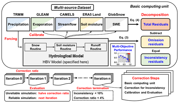
Water budget non-closure is a widespread phenomenon among multisource datasets which undermines the robustness of hydrological inferences. This study proposes a Multisource Dataset Correction Framework grounded in Physical Hydrological Process Modelling to enhance water budget closure, termed PHPM-MDCF. We examined the efficiency and robustness of the framework using the CAMELS dataset and achieved an average reduction of 49 % in total water budget residuals across 475 CONUS basins.
Hongyang Fu, Yuanyuan Yang, Dengfeng Liu, Qiang Li, Zhihua He, Huimin Lei, Mohd Yawar Ali Khan, and Fiaz Hussain
EGUsphere, https://doi.org/10.5194/egusphere-2026-2687, https://doi.org/10.5194/egusphere-2026-2687, 2026
Short summary
Short summary
Evapotranspiration changes rapidly within a day, and its plant transpiration component remains difficult to measure. We developed a machine-learning framework that estimates hourly total evapotranspiration and plant transpiration together while keeping transpiration physically bounded. This provides a physically consistent reference for plant water use at sites where only total evapotranspiration is observed.
Xudong Zheng, Dengfeng Liu, Hao Wang, Chuanhui Ma, Hui Liu, Guanghui Ming, Qiang Li, Mohd Yawar Ali Khan, and Fiaz Hussain
Hydrol. Earth Syst. Sci., 30, 2493–2521, https://doi.org/10.5194/hess-30-2493-2026, https://doi.org/10.5194/hess-30-2493-2026, 2026
Short summary
Short summary
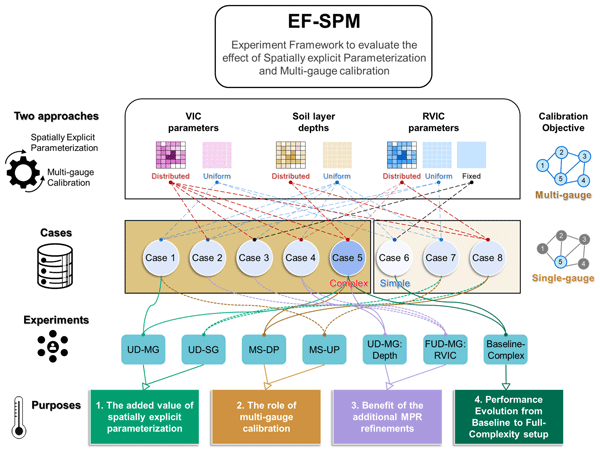
This study presents an experimental framework (EF-SPM) to disentangle and evaluate the benefits of spatially explicit parameterization and multi-gauge calibration in distributed hydrological modelling. Experiments in a nested catchment show that both strategies consistently improve streamflow simulations across sub-basins, jointly alleviating multi-objective competition and the trade-off between spatial complexity and parameter identifiability.
Megersa Adugna Gurara, Gang Zhao, Xingcai Liu, Ximeng Xu, Paul P. J. Gaffney, and Qiuhong Tang
EGUsphere, https://doi.org/10.5194/egusphere-2026-1969, https://doi.org/10.5194/egusphere-2026-1969, 2026
Short summary
Short summary
Climate change accelerates hydroclimate swings, which significantly impact water supply, agriculture, and ecosystems. We evaluate the spatiotemporal characteristics of hydrological wet-to-dry transitions based on root-zone soil moisture from 1981 to 2024. We then classify these transitions into rapid and slow events based on the onset speed. Wet-to-dry transitions become increasingly rapid and frequent as their duration decreases to a sub-monthly timescale, demanding better planning.

Bingqian Guo, Mingjie Fang, Leilei Yang, Tao Guo, Chuang Ma, Xiangyun Hu, Zhaoxiang Guo, Zemeng Ma, Qiang Li, Zhaoli Wang, and Weiguo Liu
Earth Syst. Sci. Data, 18, 429–441, https://doi.org/10.5194/essd-18-429-2026, https://doi.org/10.5194/essd-18-429-2026, 2026
Short summary
Short summary
Using satellite images and soil samples, we found that 39 065 km2 of farmland was retired across China’s Loess Plateau from 2000 to 2021, with nearly half converted to grasslands. Over two decades, these restored lands captured 21.77 million metric tons of carbon, Grasslands contributed over 80 % of this carbon storage, highlighting their critical role in climate mitigation.
Yongyong Zhang, Yongqiang Zhang, Xiaoyan Zhai, Jun Xia, Qiuhong Tang, Wei Wang, Jian Wu, Xiaoyu Niu, and Bing Han
Hydrol. Earth Syst. Sci., 29, 3257–3275, https://doi.org/10.5194/hess-29-3257-2025, https://doi.org/10.5194/hess-29-3257-2025, 2025
Short summary
Short summary
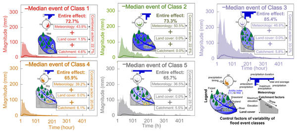
It is challenging to investigate flood variabilities and their formation mechanisms from massive event samples. This study explores spatiotemporal variabilities of 1446 flood events using hierarchical and partitional clustering methods. Control mechanisms of meteorological and physio-geographical factors are explored for individual flood event classes using constrained rank analysis. This gives insights into comprehensive changes in flood events and aids in flood prediction and control.
Xudong Zheng, Dengfeng Liu, Shengzhi Huang, Hao Wang, and Xianmeng Meng
Hydrol. Earth Syst. Sci., 29, 627–653, https://doi.org/10.5194/hess-29-627-2025, https://doi.org/10.5194/hess-29-627-2025, 2025
Short summary
Short summary
Water budget non-closure is a widespread phenomenon among multisource datasets which undermines the robustness of hydrological inferences. This study proposes a Multisource Dataset Correction Framework grounded in Physical Hydrological Process Modelling to enhance water budget closure, termed PHPM-MDCF. We examined the efficiency and robustness of the framework using the CAMELS dataset and achieved an average reduction of 49 % in total water budget residuals across 475 CONUS basins.
Ying Li, Chenghao Wang, Qiuhong Tang, Shibo Yao, Bo Sun, Hui Peng, and Shangbin Xiao
Atmos. Chem. Phys., 24, 10741–10758, https://doi.org/10.5194/acp-24-10741-2024, https://doi.org/10.5194/acp-24-10741-2024, 2024
Short summary
Short summary
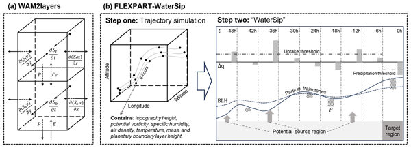
For moisture tracking over the Tibetan Plateau, we recommend using high-resolution forcing datasets, prioritizing temporal resolution over spatial resolution for WAM2layers, while for FLEXPART coupled with WaterSip, we suggest applying bias corrections to optimize the filtering of precipitation particles and adjust evaporation estimates.

Lei Huang, Yong Luo, Jing M. Chen, Qiuhong Tang, Tammo Steenhuis, Wei Cheng, and Wen Shi
Earth Syst. Sci. Data, 16, 3993–4019, https://doi.org/10.5194/essd-16-3993-2024, https://doi.org/10.5194/essd-16-3993-2024, 2024
Short summary
Short summary
Timely global terrestrial evapotranspiration (ET) data are crucial for water resource management and drought forecasting. This study introduces the VISEA algorithm, which integrates satellite data and shortwave radiation to provide daily 0.05° gridded near-real-time ET estimates. By employing a vegetation index–temperature method, this algorithm can estimate ET without requiring additional data. Evaluation results demonstrate VISEA's comparable accuracy with accelerated data availability.
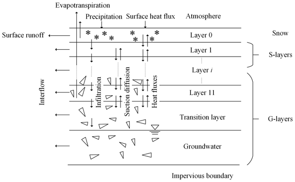
Pengxiang Wang, Zuhao Zhou, Jiajia Liu, Chongyu Xu, Kang Wang, Yangli Liu, Jia Li, Yuqing Li, Yangwen Jia, and Hao Wang
Hydrol. Earth Syst. Sci., 27, 2681–2701, https://doi.org/10.5194/hess-27-2681-2023, https://doi.org/10.5194/hess-27-2681-2023, 2023
Short summary
Short summary
Considering the impact of the special geological and climatic conditions of the Qinghai–Tibet Plateau on the hydrological cycle, this study established the WEP-QTP hydrological model. The snow cover and gravel layers affected the temporal and spatial changes in frozen soil and improved the regulation of groundwater on the flow process. Ignoring he influence of special underlying surface conditions has a great impact on the hydrological forecast and water resource utilization in this area.
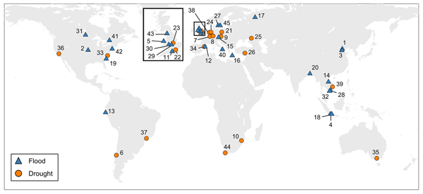
Heidi Kreibich, Kai Schröter, Giuliano Di Baldassarre, Anne F. Van Loon, Maurizio Mazzoleni, Guta Wakbulcho Abeshu, Svetlana Agafonova, Amir AghaKouchak, Hafzullah Aksoy, Camila Alvarez-Garreton, Blanca Aznar, Laila Balkhi, Marlies H. Barendrecht, Sylvain Biancamaria, Liduin Bos-Burgering, Chris Bradley, Yus Budiyono, Wouter Buytaert, Lucinda Capewell, Hayley Carlson, Yonca Cavus, Anaïs Couasnon, Gemma Coxon, Ioannis Daliakopoulos, Marleen C. de Ruiter, Claire Delus, Mathilde Erfurt, Giuseppe Esposito, Didier François, Frédéric Frappart, Jim Freer, Natalia Frolova, Animesh K. Gain, Manolis Grillakis, Jordi Oriol Grima, Diego A. Guzmán, Laurie S. Huning, Monica Ionita, Maxim Kharlamov, Dao Nguyen Khoi, Natalie Kieboom, Maria Kireeva, Aristeidis Koutroulis, Waldo Lavado-Casimiro, Hong-Yi Li, Maria Carmen LLasat, David Macdonald, Johanna Mård, Hannah Mathew-Richards, Andrew McKenzie, Alfonso Mejia, Eduardo Mario Mendiondo, Marjolein Mens, Shifteh Mobini, Guilherme Samprogna Mohor, Viorica Nagavciuc, Thanh Ngo-Duc, Huynh Thi Thao Nguyen, Pham Thi Thao Nhi, Olga Petrucci, Nguyen Hong Quan, Pere Quintana-Seguí, Saman Razavi, Elena Ridolfi, Jannik Riegel, Md Shibly Sadik, Nivedita Sairam, Elisa Savelli, Alexey Sazonov, Sanjib Sharma, Johanna Sörensen, Felipe Augusto Arguello Souza, Kerstin Stahl, Max Steinhausen, Michael Stoelzle, Wiwiana Szalińska, Qiuhong Tang, Fuqiang Tian, Tamara Tokarczyk, Carolina Tovar, Thi Van Thu Tran, Marjolein H. J. van Huijgevoort, Michelle T. H. van Vliet, Sergiy Vorogushyn, Thorsten Wagener, Yueling Wang, Doris E. Wendt, Elliot Wickham, Long Yang, Mauricio Zambrano-Bigiarini, and Philip J. Ward
Earth Syst. Sci. Data, 15, 2009–2023, https://doi.org/10.5194/essd-15-2009-2023, https://doi.org/10.5194/essd-15-2009-2023, 2023
Short summary
Short summary
As the adverse impacts of hydrological extremes increase in many regions of the world, a better understanding of the drivers of changes in risk and impacts is essential for effective flood and drought risk management. We present a dataset containing data of paired events, i.e. two floods or two droughts that occurred in the same area. The dataset enables comparative analyses and allows detailed context-specific assessments. Additionally, it supports the testing of socio-hydrological models.

Zhihui Wang, Qiuhong Tang, Daoxi Wang, Peiqing Xiao, Runliang Xia, Pengcheng Sun, and Feng Feng
Hydrol. Earth Syst. Sci., 26, 5291–5314, https://doi.org/10.5194/hess-26-5291-2022, https://doi.org/10.5194/hess-26-5291-2022, 2022
Short summary
Short summary
Variable infiltration capacity simulation considering dynamic vegetation types and structural parameters is able to better capture the effect of temporally explicit vegetation change and climate variation in hydrological regimes. Vegetation greening including interannual LAI and intra-annual LAI temporal pattern change induced by large-scale ecological restoration and non-vegetation underlying surface change played dominant roles in the natural streamflow reduction of the Yellow River basin.

Yubo Liu, Monica Garcia, Chi Zhang, and Qiuhong Tang
Hydrol. Earth Syst. Sci., 26, 1925–1936, https://doi.org/10.5194/hess-26-1925-2022, https://doi.org/10.5194/hess-26-1925-2022, 2022
Short summary
Short summary
Our findings indicate that the reduction in contribution to the Iberian Peninsula (IP) summer precipitation is mainly concentrated in the IP and its neighboring grids. Compared with 1980–1997, both local recycling and external moisture were reduced during 1998–2019. The reduction in local recycling in the IP closely links to the disappearance of the wet years and the decreasing contribution in the dry years.
Pengxiang Wang, Zuhao Zhou, Jiajia Liu, Chongyu Xu, Kang Wang, Yangli Liu, Jia Li, Yuqing Li, Yangwen Jia, and Hao Wang
Hydrol. Earth Syst. Sci. Discuss., https://doi.org/10.5194/hess-2021-538, https://doi.org/10.5194/hess-2021-538, 2021
Manuscript not accepted for further review
Short summary
Short summary
Combining the geological characteristics of the thin soil layer on the thick gravel layer and the climate characteristics of the long-term snow cover of the Qinghai-Tibet Plateau, the WEP-QTP hydrological model was constructed by dividing a single soil structure into soil and gravel. In contrast to the general cold area, the special environment of the Qinghai–Tibet Plateau affects the hydrothermal transport process, which can not be ignored in hydrological forecast and water resource assessment.
Cited articles
Addor, N., Newman, A. J., Mizukami, N., and Clark, M. P.: The CAMELS data set: catchment attributes and meteorology for large-sample studies, Hydrol. Earth Syst. Sci., 21, 5293–5313, https://doi.org/10.5194/hess-21-5293-2017, 2017.
Argentin, A.-L., Horton, P., Schaefli, B., Shokory, J., Pitscheider, F., Repnik, L., Gianini, M., Bizzi, S., Lane, S. N., and Comiti, F.: Scale dependency in modeling nivo-glacial hydrological systems: the case of the Arolla basin, Switzerland, Hydrol. Earth Syst. Sci., 29, 1725–1748, https://doi.org/10.5194/hess-29-1725-2025, 2025.
Balsamo, G., Beljaars, A., Scipal, K., Viterbo, P., van den Hurk, B., Hirschi, M., and Betts, A. K.: A revised hydrology for the ECMWF model: Verification from field site to terrestrial water storage and impact in the Integrated Forecast System, J. Hydrometeorol., 10, 623–643, https://doi.org/10.1175/2008JHM1068.1, 2009.
Bao, Z., Zhang, J.-Y., Liu, J., Fu, G., Wang, G., He, R., Yan, X., Jin, J., and Liu, H.: Comparison of regionalization approaches based on regression and similarity for predictions in ungauged catchments under multiple hydro-climatic conditions, J. Hydrol., 466–467, 37–46, https://doi.org/10.1016/j.jhydrol.2012.07.048, 2012.
Barrios, M. and Frances, F.: Spatial scale effect on the upper soil effective parameters of a distributed hydrological model, Hydrol. Process., 26, 1022–1033, https://doi.org/10.1002/hyp.8193, 2012.
Beven, K.: Towards an Alternative Blueprint for a Physically Based Digitally Simulated Hydrologic Response Modelling System, Hydrol. Process., 16, 189–206, https://doi.org/10.1002/hyp.343, 2002.
Beven, K.: A brief history of information and disinformation in hydrological data and the impact on the evaluation of hydrological models, Hydrolog. Sci. J., 69, 519–527, https://doi.org/10.1080/02626667.2024.2332616, 2024.
Bieger, D., Sheba, A., Hassan, A., Aly, S., Chen, R., Liang, X., and Liang, Y.: Sustaining CyberWater-VisTrails: A Case Study in Software Upgrades and Reengineering, Information, 16, 988, https://doi.org/10.3390/info16110988, 2025.
Bohn, T. J. and Vivoni, E. R.: MOD-LSP, MODIS-based parameters for hydrologic modelling of North American land cover change, Sci. Data, 6, 144, https://doi.org/10.1038/s41597-019-0150-2, 2019.
Broman, D., Voisin, N., Kao, S.-C., Fernandez, A., and Ghimire, G.: Multi-scale impacts of climate change on hydropower for long-term water-energy planning in the contiguous United States, Environ. Res. Lett., 19, https://doi.org/10.1088/1748-9326/ad6ceb, 2024.
Campbell, G.: A Simple Method for Determining Unsaturated Conductivity From Moisture Retention Data, Soil Sci., 117, https://doi.org/10.1097/00010694-197406000-00001, 1974.
Carvalho, V. S. O., da Cunha, Z. A., Alvarenga, L. A., Beskow, S., de Mello, C. R., Martins, M. A., and de Oliveira, C. de M. M.: Assessment of land use changes in the Verde River basin using two hydrological models, J. S. Am. Earth Sci., 118, 103954, https://doi.org/10.1016/j.jsames.2022.103954, 2022.
Chagas, V., Chaffe, P., and Blöschl, G.: Regional Low Flow Hydrology: Model Development and Evaluation, Water Resour. Res., 60, https://doi.org/10.1029/2023WR035063, 2024.
Chen, Y., Shi, P., Ji, X., Qu, S., Zhao, L., and Dong, F.: New method to calculate the dynamic factor–flow velocity in Geomorphologic instantaneous unit hydrograph, Sci. Rep.-UK, 9, https://doi.org/10.1038/s41598-019-50723-x, 2019.
Cortés-Salazar, N., Vásquez, N., Mizukami, N., Mendoza, P. A., and Vargas, X.: To what extent does river routing matter in hydrological modeling?, Hydrol. Earth Syst. Sci., 27, 3505–3524, https://doi.org/10.5194/hess-27-3505-2023, 2023.
Cosby Jr., B., Hornberger, G., Clapp, R., and Ginn, T.: A Statistical Exploration of Relationships of Soil Moisture Characteristics to the Physical Properties of Soils, Water Resour. Res., 20, 682–690, https://doi.org/10.1029/WR020i006p00682, 1984.
Da Costa-Luis, C.: tqdm: A Fast, Extensible Progress Meter for Python and CLI, Journal of Open Source Software, 4, 1277, https://doi.org/10.21105/joss.01277, 2019.
Dai, Y., Shangguan, W., Duan, Q., Liu, B., Fu, S., and Niu, G.: Development of a China Dataset of Soil Hydraulic Parameters Using Pedotransfer Functions for Land Surface Modelling, J. Hydrometeorol., https://doi.org/10.1175/JHM-D-12-0149.1, 2013.
Deb, K., Pratap, A., Agarwal, S., and Meyarivan, T.: A fast and elitist multiobjective genetic algorithm: NSGA-II, IEEE T. Evolut. Comput., 6, https://doi.org/10.1109/4235.996017, 2002.
Didan, K.: MODIS/Terra Vegetation Indices Monthly L3 Global 1 km SIN Grid V061 (V061), NASA Land Processes Distributed Active Archive Center [data set], https://doi.org/10.5067/MODIS/MOD13A3.061, 2021.
Dümenil, L. and Todini, E.: A rainfall–runoff scheme for use in the Hamburg climate model, in: Advances in Theoretical Hydrology, Chapter 9, edited by: O'Kane, J. P., Elsevier, Amsterdam, 129–157, https://doi.org/10.1016/B978-0-444-89831-9.50016-8, 1992.
Fortin, F.-A., De Rainville, F.-M., Gardner, M. A., Parizeau, M., and Gagné, C.: DEAP: Evolutionary algorithms made easy, J. Mach. Learn. Res., 13, 2171–2175, 2012.
Gillies, S.: Rasterio: geospatial raster I/O for Python programmers, Mapbox [code], https://github.com/rasterio/rasterio (last access: 2 November 2026), 2013.
Gou, J., Miao, C., Duan, Q., Tang, Q., Di, Z., Liao, W., Wu, J., and Zhou, R.: Sensitivity analysis-based automatic parameter calibration of the variable infiltration capacity (VIC) model for streamflow simulations over China, Water Resour. Res., 56, https://doi.org/10.1029/2019WR025968, 2020.
Gou, J., Miao, C., Samaniego, L., Xiao, M., Wu, J., and Guo, X.: CNRD v1.0: A High-Quality Natural Runoff Dataset for Hydrological and Climate Studies in China, B. Am. Meteorol. Soc., 102, E929–E947, https://doi.org/10.1175/BAMS-D-20-0094.1, 2021.
Gu, H. T., Liu, L., Bai, Z. X., Pan, S. L., and Xu, Y. P.: A stepwise surrogate model for parameter calibration of the Variable Infiltration Capacity model: the case of the upper Brahmaputra, Tibet Plateau, J. Hydroinform., 23, 171–191, https://doi.org/10.2166/hydro.2020.010, 2021.
Guo, J.: General and Analytic Unit Hydrograph and Its Applications, J. Hydrol. Eng., 27, https://doi.org/10.1061/(ASCE)HE.1943-5584.0002149, 2022.
Gupta, H., Kling, H., Yilmaz, K., and Martinez, G.: Decomposition of the Mean Squared Error and NSE Performance Criteria: Implications for Improving Hydrological Modelling, J. Hydrol., 377, 80–91, https://doi.org/10.1016/j.jhydrol.2009.08.003, 2009.
Gupta, H. V., Perrin, C., Blöschl, G., Montanari, A., Kumar, R., Clark, M., and Andréassian, V.: Large-sample hydrology: a need to balance depth with breadth, Hydrol. Earth Syst. Sci., 18, 463–477, https://doi.org/10.5194/hess-18-463-2014, 2014.
Hamman, J. J., Nijssen, B., Bohn, T. J., Gergel, D. R., and Mao, Y.: The Variable Infiltration Capacity model version 5 (VIC-5): infrastructure improvements for new applications and reproducibility, Geosci. Model Dev., 11, 3481–3496, https://doi.org/10.5194/gmd-11-3481-2018, 2018.
Hansen, M., Defries, R., Townshend, J., and Sohlberg, R.: Global land cover classification at 1 km resolution using a decision tree classifier, J. Remote Sens., https://doi.org/10.1080/014311600210209, 2021.
Hansen, N. and Ostermeier, A.: Completely Derandomized Self-Adaptation in Evolution Strategies, Evol. Comput., 9, 159–195, https://doi.org/10.1162/106365601750190398, 2001.
Harris, C., Millman, K., Walt, S., Gommers, R., Virtanen, P., Cournapeau, D., Wieser, E., Taylor, J., Berg, S., Smith, N., Kern, R., Picus, M., Hoyer, S., Kerkwijk, M., Brett, M., Haldane, A., Río, J., Wiebe, M., Peterson, P., and Oliphant, T.: Array programming with NumPy, Nature, 585, 357–362, https://doi.org/10.1038/s41586-020-2649-2, 2020.
He, J., Yang, K., Tang, W., Lu, H., Qin, J., Chen, Y., and Li, X.: The first high-resolution meteorological forcing dataset for land process studies over China, Sci. Data, 7, 25, https://doi.org/10.1038/s41597-020-0369-y, 2020.
Hengl, T., Mendes de Jesus, J., Macmillan, R. A., Batjes, N., Heuvelink, G., Ribeiro, E., Samuel-Rosa, A., Kempen, B., Leenaars, J. G. B., Walsh, M., and Gonzalez, M.: SoilGrids1km – Global Soil Information Based on Automated Mapping, Plos One, 9, e105992, https://doi.org/10.1371/journal.pone.0105992, 2014.
Hoyer, S. and Hamman, J.: xarray: N-D labeled Arrays and Datasets in Python, Journal of Open Research Software, 5, https://doi.org/10.5334/jors.148, 2017.
Hunter, J.: Matplotlib: A 2D Graphics Environment, Comput. Sci. Eng., 9, 90–95, https://doi.org/10.1109/MCSE.2007.55, 2007.
Huynh, N. N. T., Garambois, P.-A., Colleoni, F., Renard, B., Roux, H., Demargne, J., Jay-Allemand, M., and Javelle, P.: Learning Regionalization Using Accurate Spatial Cost Gradients Within a Differentiable High-Resolution Hydrological Model: Application to the French Mediterranean Region, Water Resour. Res., 60, https://doi.org/10.1029/2024WR037544, 2024.
Jarvis, A., Reuter, H., Nelson, A., and Guevara, E.: Hole-filled seamless SRTM data V4. Tech. rep., International Centre for Tropical Agriculture (CIAT), Cali, Columbia, https://srtm.csi.cgiar.org/srtmdata/ (last access: 2 November 2026), 2008.
Jia, X., Shao, M. A., Zhang, C., and Zhao, C.: Regional temporal persistence of dried soil layer along south-north transect of the Loess Plateau, China, J. Hydrol., 528, https://doi.org/10.1016/j.jhydrol.2015.06.025, 2015.
Jordahl, K., Van den Bossche, J., Fleischmann, M., Wasserman, J., McBride, J., Gerard, J., Tratner, J., Perry, M., Badaracco, A. G., Farmer, C., Hjelle, G. A., Snow, A. D., Cochran, M., Gillies, S., Culbertson, L., Bartos, M., Eubank, N., maxalbert, Bilogur, A., Rey, S., Ren, C., Arribas-Bel, D., Wasser, L., Wolf, L. J., Journois, M., Wilson, J., Greenhall, A., Holdgraf, C., Filipe, and Leblanc, F.: geopandas/geopandas: v0.8.1, Zenodo [code], https://doi.org/10.5281/zenodo.3946761, 2020.
Knoben, W., Clark, M., Bales, J., Bennett, A., Gharari, S., Marsh, C., Nijssen, B., Pietroniro, A., Spiteri, R., Tang, G., Tarboton, D., and Wood, A.: Community Workflows to Advance Reproducibility in Hydrologic Modeling: Separating Model-Agnostic and Model-Specific Configuration Steps in Applications of Large-Domain Hydrologic Models, Water Resour. Res., 58, https://doi.org/10.1029/2021WR031753, 2022.
Lehmann, F., Vishwakarma, B. D., and Bamber, J.: How well are we able to close the water budget at the global scale?, Hydrol. Earth Syst. Sci., 26, 35–54, https://doi.org/10.5194/hess-26-35-2022, 2022.
Liang, X., Lettenmaier, D., Wood, E., and Burges, S.: A Simple hydrologically Based Model of Land Surface Water and Energy Fluxes for GSMs, J. Geophys. Res., 99, https://doi.org/10.1029/94JD00483, 1994.
Lindsay, J. and Wu, Q.: Whitebox Workflows for Python (v1.0), Python Package Index (PyPI) [code], https://pypi.org/project/whitebox-workflows/ (last access: 2 November 2026), 2021.
Liu, D., Tian, F., Hu, H., and Hu, H.: The role of run-on for overland flow and the characteristics of runoff generation in the Loess Plateau, China, Hydrolog. Sci. J., 57, 1–11, https://doi.org/10.1080/02626667.2012.695870, 2012a.
Liu, Y., Weerts, A. H., Clark, M., Hendricks Franssen, H.-J., Kumar, S., Moradkhani, H., Seo, D.-J., Schwanenberg, D., Smith, P., van Dijk, A. I. J. M., van Velzen, N., He, M., Lee, H., Noh, S. J., Rakovec, O., and Restrepo, P.: Advancing data assimilation in operational hydrologic forecasting: progresses, challenges, and emerging opportunities, Hydrol. Earth Syst. Sci., 16, 3863–3887, https://doi.org/10.5194/hess-16-3863-2012, 2012b.
Lohmann, D., Nolte-Holube, R., and Raschke, E.: A large-scale horizontal routing model to be coupled to land surface parametrization schemes, Tellus A, 48, 708–721, https://doi.org/10.3402/tellusa.v48i5.12200, 1996.
Martens, B., Miralles, D. G., Lievens, H., van der Schalie, R., de Jeu, R. A. M., Fernández-Prieto, D., Beck, H. E., Dorigo, W. A., and Verhoest, N. E. C.: GLEAM v3: satellite-based land evaporation and root-zone soil moisture, Geosci. Model Dev., 10, 1903–1925, https://doi.org/10.5194/gmd-10-1903-2017, 2017.
McKay, M., Beckman, R., and Conover, W.: A Comparison of Three Methods for Selecting Values of Input Variables in the Analysis of Output from a Computer Code, Technometrics, 21, 239–245, https://doi.org/10.2307/1268522, 1979.
McKinney, W.: pandas: a Foundational Python Library for Data Analysis and Statistics, Python High Performance Science Computer, https://pandas.pydata.org/ (last access: 2 November 2026), 2011.
Mei, Y., Mai, J., Do, H., Gronewold, A., Reeves, H., Eberts, S., Niswonger, R., Regan, R., and Hunt, R.: Can Hydrological Models Benefit From Using Global Soil Moisture, Evapotranspiration, and Runoff Products as Calibration Targets?, Water Resour. Res., 59, https://doi.org/10.1029/2022WR032064, 2023.
Met Office: Cartopy: a cartographic python library with a Matplotlib interface, https://scitools.org.uk/cartopy/ (last access: 2 November 2026), 2010–2015.
Miao, Y. and Wang, A.: A daily 0.25°×0.25° hydrologically based land surface flux dataset for conterminous China, 1961–2017, J. Hydrol., 590, 125413, https://doi.org/10.1016/j.jhydrol.2020.125413, 2020.
Miller, D. A. and White, R. A.: A Conterminous United States Multilayer Soil Characteristics Dataset for Regional Climate and Hydrology Modeling, Earth Interact, 2, 1–26, https://doi.org/10.1175/1087-3562(1998)002<0001:ACUSMS>2.3.CO;2, 1998.
Mizukami, N., Clark, M., Newman, A., Wood, A., Gutmann, E., Nijssen, B., Rakovec, O., and Samaniego, L.: Toward seamless large domain parameter estimation for hydrologic models, Water Resour. Res., 53, https://doi.org/10.1002/2017wr020401, 2017.
Mizukami, N., Rakovec, O., Newman, A. J., Clark, M. P., Wood, A. W., Gupta, H. V., and Kumar, R.: On the choice of calibration metrics for “high-flow” estimation using hydrologic models, Hydrol. Earth Syst. Sci., 23, 2601–2614, https://doi.org/10.5194/hess-23-2601-2019, 2019.
Muñoz Sabater, J.: ERA5-Land monthly averaged data from 1950 to present, Copernicus Climate Change Service (C3S) Climate Data Store (CDS) [data set], https://doi.org/10.24381/cds.68d2bb30, 2019.
Myneni, R., Knyazikhin, Y., and Park, T.: MODIS/Terra Leaf Area Index/FPAR 8-Day L4 Global 500m SIN Grid V061 (V061), NASA Land Processes Distributed Active Archive Center [data set], https://doi.org/10.5067/MODIS/MOD15A2H.061, 2021.
Newman, A. J., Clark, M. P., Sampson, K., Wood, A., Hay, L. E., Bock, A., Viger, R. J., Blodgett, D., Brekke, L., Arnold, J. R., Hopson, T., and Duan, Q.: Development of a large-sample watershed-scale hydrometeorological data set for the contiguous USA: data set characteristics and assessment of regional variability in hydrologic model performance, Hydrol. Earth Syst. Sci., 19, 209–223, https://doi.org/10.5194/hess-19-209-2015, 2015.
Ngo-Duc, T., Oki, T., and Kanae, S.: A variable streamflow velocity method for global river routing model: model description and preliminary results, Hydrol. Earth Syst. Sci. Discuss., 4, 4389–4414, https://doi.org/10.5194/hessd-4-4389-2007, 2007.
Nicolle, P., Pushpalatha, R., Perrin, C., François, D., Thiéry, D., Mathevet, T., Le Lay, M., Besson, F., Soubeyroux, J.-M., Viel, C., Regimbeau, F., Andréassian, V., Maugis, P., Augeard, B., and Morice, E.: Benchmarking hydrological models for low-flow simulation and forecasting on French catchments, Hydrol. Earth Syst. Sci., 18, 2829–2857, https://doi.org/10.5194/hess-18-2829-2014, 2014.
Nijssen, B., Lettenmaier, D., Lohmann, D., and Wood, E.: Predicting the Discharge of Global Rivers, J. Climate, 14, 3307–3323, https://doi.org/10.1175/1520-0442(2001)014<3307:PTDOGR>2.0.CO;2, 2001.
NLDAS project: NLDAS Primary Forcing Data L4 Hourly 0.125 × 0.125 degree V2.0, edited by: Mocko, D. M., NASA/GSFC/HSL, Greenbelt, Maryland, USA, Goddard Earth Sciences Data and Information Services Center (GES DISC) [data set], https://doi.org/10.5067/THUF4J1RLSYG, 2021.
Peters-Lidard, C., Blackburn, E., Liang, X., and Wood, E.: The Effect of Soil Thermal Conductivity Parameterization on Surface Energy Fluxes and Temperatures, J. Atmos. Sci., 55, 1209–1224, https://doi.org/10.1175/1520-0469(1998)055<1209:TEOSTC>2.0.CO;2, 1998.
Poggio, L., de Sousa, L. M., Batjes, N. H., Heuvelink, G. B. M., Kempen, B., Ribeiro, E., and Rossiter, D.: SoilGrids 2.0: producing soil information for the globe with quantified spatial uncertainty, SOIL, 7, 217–240, https://doi.org/10.5194/soil-7-217-2021, 2021.
Qiu, L., Wu, Y., Wang, L., Lei, X., Liao, W., Hui, Y., and Meng, X.: Spatiotemporal response of the water cycle to land use conversions in a typical hilly–gully basin on the Loess Plateau, China, Hydrol. Earth Syst. Sci., 21, 6485–6499, https://doi.org/10.5194/hess-21-6485-2017, 2017.
Rakovec, O., Kumar, R., Attinger, S., and Samaniego, L.: Improving the realism of hydrologic model functioning through multivariate parameter estimation, Water Resour. Res., 52, https://doi.org/10.1002/2016WR019430, 2016.
Rew, R. and Davis, G.: NetCDF: An interface for scientific data access, IEEE Comput. Graph., 10, 76–82, https://doi.org/10.1109/38.56302, 1990.
Salas, D., Liang, X., Navarro, M., Liang, Y., and Luna, D.: An open-data open-model framework for hydrological models' integration, evaluation and application, Environ. Modell. Softw., 126, 104622, https://doi.org/10.1016/j.envsoft.2020.104622, 2020.
Samaniego, L., Kumar, R., and Attinger, S.: Multiscale parameter regionalization of a grid-based hydrologic model at the mesoscale, Water Resour. Res., 46, https://doi.org/10.1029/2008WR007327, 2010.
Schaaf, C. and Wang, Z.: MODIS/Terra+Aqua BRDF/Albedo Black Sky Albedo Shortwave Daily L3 Global 30ArcSec CMG V061 (V061), NASA Land Processes Distributed Active Archive Center [data set], https://doi.org/10.5067/MODIS/MCD43D51.061, 2021.
Schaperow, J., Li, D., Margulis, S., and Lettenmaier, D.: A near-global, high resolution land surface parameter dataset for the variable infiltration capacity model, Sci. Data, 8, 216, https://doi.org/10.1038/s41597-021-00999-4, 2021.
Schulze, K., Hunger, M., and Döll, P.: Simulating river flow velocity on global scale, Adv. Geosci., 5, 133–136, https://doi.org/10.5194/adgeo-5-133-2005, 2005.
Sherman, L. K.: Streamflow from rainfall by unit-graph method, Eng. News-Rec., 108, 501–505, 1932.
Singh, S., Pahlow, M., Booker, D., Shankar, U., and Chamorro, A.: Towards baseflow index characterisation at national scale in New Zealand, J. Hydrol., 568, https://doi.org/10.1016/j.jhydrol.2018.11.025, 2018.
Sun, R., Duan, Q., and Huo, X.: Multi-Objective Adaptive Surrogate Modelling-Based Optimization for Distributed Environmental Models Based on Grid Sampling, Water Resour. Res., 57, https://doi.org/10.1029/2020WR028740, 2021.
Sun, R., Pan, B., and Duan, Q.: A surrogate modelling method for distributed land surface hydrological models based on deep learning, J. Hydrol., 624, 129944, https://doi.org/10.1016/j.jhydrol.2023.129944, 2023.
Tang, G., Clark, M., Knoben, W., Liu, H., Gharari, S., Arnal, L., Wood, A., Newman, A., Freer, J., and Papalexiou, S. M.: Uncertainty Hotspots in Global Hydrologic Modeling: The Impact of Precipitation and Temperature Forcings, B. Am. Meteorol. Soc., 106, E146–E166, https://doi.org/10.1175/BAMS-D-24-0007.1, 2025.
van den Hurk, B. and Viterbo, P.: The Torne-Kalix PILPS 2(e) experiment as a test bed for modifications to the ECMWF land surface scheme, Global Planet. Change, 38, 165–173, https://doi.org/10.1016/S0921-8181(03)00027-4, 2003.
Viney, N. and Sivapalan, M.: A framework for scaling of hydrologic conceptualizations based on a disaggregation–aggregation approach, Hydrol. Process., 18, 1395–1408, https://doi.org/10.1002/hyp.1419, 2004.
Virtanen, P., Gommers, R., Oliphant, T., Haberland, M., Reddy, T., Cournapeau, D., Burovski, E., Peterson, P., Weckesser, W., Bright, J., Walt, S., Brett, M., Wilson, J., Millman, K., Mayorov, N., Nelson, A., Jones, E., Kern, R., Larson, E., and Vázquez-Baeza, Y.: SciPy 1.0: fundamental algorithms for scientific computing in Python, Nat. Methods, 17, 1–12, https://doi.org/10.1038/s41592-019-0686-2, 2020.
Wambura, F. J., Dietrich, O., and Lischeid, G.: Improving a distributed hydrological model using evapotranspiration-related boundary conditions as additional constraints in a data-scarce river basin, Hydrol. Process., 32, 759–775, https://doi.org/10.1002/hyp.11453, 2018.
Wang, J., Zhuo, L., Han, D., Liu, Y., and Rico-Ramirez, M.: Hydrological model adaptability to rainfall inputs of varied quality, Water Resour. Res., 59, e2022WR032484, https://doi.org/10.1029/2022WR032484, 2023.
Wang, Z., Vivoni, E., Whitney, K., Xiao, M., and Mascaro, G.: On the Sensitivity of Future Hydrology in the Colorado River to the Selection of the Precipitation Partitioning Method, Water Resour. Res., 60, https://doi.org/10.1029/2023WR035801, 2024.
Wenger, S. J., Luce, C. H., Hamlet, A. F., Isaak, D. J., and Neville, H. M.: Macroscale hydrologic modelling of ecologically relevant flow metrics, Water Resour. Res., 46, W09513, https://doi.org/10.1029/2009wr008839, 2010.
Wi, S., Ray, P., Demaria, E. M. C., Steinschneider, S., and Brown, C.: A user-friendly software package for VIC hydrologic model development, Environ. Modell. Softw., 98, 35–53, https://doi.org/10.1016/j.envsoft.2017.09.006, 2017.
Xia, Y., Mitchell, K., Ek, M., Sheffield, J., Brian, C., Wood, E., Luo, L., Alonge, C., Wei, H., Meng, J., Livneh, B., Lettenmaier, D., Koren, V., Duan, Q., Mo, K., Fan, Y., and Mocko, D.: Continental-Scale Water and Energy Flux Analysis and Validation for the North American Land Data Assimilation System Project Phase 2 (NLDAS-2): 1. Intercomparison and Application of Model Products, J. Geophys. Res.-Atmos., 117, 3109, https://doi.org/10.1029/2011JD016048, 2012.
Yan, H., Sun, N., Eldardiry, H., Thurber, T., Reed, P., Malek, K., Gupta, R., Kennedy, D., Swenson, S., Hou, Z., Cheng, Y., and Rice, J.: Large Ensemble Diagnostic Evaluation of Hydrologic Parameter Uncertainty in the Community Land Model Version 5 (CLM5), J. Adv. Model. Earth Sy., 15, https://doi.org/10.1029/2022MS003312, 2023.
Yang, Y., Endreny, T. A., and Nowak, D. J.: Application of advection-diffusion routing model to flood wave propagation: A case study on Big Piney River, Missouri USA, J. Earth Sci.-China, 27, 9–14, https://doi.org/10.1007/s12583-016-0626-3, 2016.
Yeste, P., García-Valdecasas Ojeda, M., Gámiz-Fortis, S. R., Castro-Díez, Y., Bronstert, A., and Esteban-Parra, M. J.: A large-sample modelling approach towards integrating streamflow and evaporation data for the Spanish catchments, Hydrol. Earth Syst. Sci., 28, 5331–5352, https://doi.org/10.5194/hess-28-5331-2024, 2024.
Zhang, Z., Chen, Y., Zhang, G., and Zhang, X.: Simulation of Hydrological Processes in the Jing River Basin Based on the WEP Model, Water-Sui, 15, 2989, https://doi.org/10.3390/w15162989, 2023.
Zheng, X.: Easy VIC Build v0.2.0, Zenodo [computer software], https://doi.org/10.5281/zenodo.21738705, 2026a.
Zheng, X.: Data for “An Open-Source Python Framework for the Flexible Deployment and Advanced Applications of the Variable Infiltration Capacity (VIC) Model”, Zenodo [data set], https://doi.org/10.5281/zenodo.21771543, 2026b.
Zheng, X., Liu, D., Wang, H., Ma, C., Liu, H., Ming, G., Li, Q., Khan, M. Y. A., and Hussain, F.: What can hydrological modelling gain from spatially explicit parameterization and multi-gauge calibration?, Hydrol. Earth Syst. Sci., 30, 2493–2521, https://doi.org/10.5194/hess-30-2493-2026, 2026.
Zhong, L., Lei, H., and Gao, B.: Developing a Physics-Informed Deep Learning Model to Simulate Runoff Response to Climate Change in Alpine Catchments, Water Resour. Res., 59, https://doi.org/10.1029/2022wr034118, 2023.
Zink, M., Kumar, R., Cuntz, M., and Samaniego, L.: A high-resolution dataset of water fluxes and states for Germany accounting for parametric uncertainty, Hydrol. Earth Syst. Sci., 21, 1769–1790, https://doi.org/10.5194/hess-21-1769-2017, 2017.
Short summary
Hydrological models help scientists understand water movement and predict changes in water resources. However, their increasing complexity makes them difficult to use. This study developed an open-source framework to simplify the setup and application of the Variable Infiltration Capacity model. Tests in multiple basins showed that the framework improves efficiency, provides reliable simulations, and supports wider use of hydrological models.
Hydrological models help scientists understand water movement and predict changes in water...


Altmetrics
Final-revised paper
Preprint